The following article is by my friend Bill Dollarhide, taken from his book, Wisconsin Censuses & Substitute Name Lists, 1685-2013.
 Prologue: Before and during the Revolutionary War, the Wisconsin area was so important to early fur trading operations of the British Hudson’s Bay Company, that for some thirty years after the war, the British refused to leave the area. How Wisconsin got to be so important started with the French era of Quebéc and Upper Louisiana:
1671. The French established a Jesuit mission at La Baie des Puants (now Green Bay).
1673. French explorers Jacques Marquette and Louis Jolliet left their base in Ste. Sault Marie, descended the Illinois River, and became the first Frenchmen to discover the Mississippi River. They spent some time exploring the area between the Illinois and Wisconsin Rivers, then floated down the Mississippi as far as the mouth of the Arkansas before returning to the Great Lakes.
1682. René-Robert Cavelier (Sieur de LaSalle) erected a cross near the confluence of the Mississippi River and the Gulf of Mexico, after floating down river from the Illinois Country. He claimed the entire Mississippi Basin for Louis XIV of France, for whom Louisiana was named. All of the rivers and streams flowing into the Mississippi were part of the Mississippi Basin and included in the Louisiana claim.
1685. French-Canadian fur traders established a trading post at Prairie du Chien, the point where the Wisconsin river enters the Mississippi. During the entire French Era, the Wisconsin area was made up of mostly single French voyageurs engaged in fur trading with the Indians. Many of the voyageurs had taken native woman as wives, and their offspring became known as the Métis. (French for “mixed”). By the end of the French era in North America, the dominant French population was the Métis.
1717. French Louisiana. The Illinois Country was officially added to the French Louisiana jurisdiction within New France. At that time la Louisiane Française extended from the Wabash River, down the Ohio and Mississippi Rivers to include several ports on the Gulf of Mexico. Any trading posts or forts north of the Highlands (Terra Haute) were considered part of Québec.
1754-1763. French and Indian War. In the early 1750s, the Ohio Company of Virginia asserted the British claim to the Ohio Country and began sending fur trading parties to the area. At the same time, French traders converged on the Ohio River. The British encroachment into “New France” and the French encroachment into “Virginia” led to a war between Britain and France. The first French fort in the area was at the Forks of the Ohio (Fort Duquesne, now Pittsburgh) which became the focus of British forays into the western wilderness of colonial America for the first time. The war escalated into a world-wide conflict called the Seven Years War. It involved most of the European great powers of the time, and affected Europe, the Americas, West Africa, India, and the Philippines.
1763-1764. At the 1763 Treaty of Paris ending the Seven Years War, the British acquired all of the French claims east of the Mississippi and Quebéc, which they renamed British Canada. The French were asked to leave North America. While the French military left immediately, the Voyageurs / Métis had lost their ties to France and remained. The few French settlements in the Great Lakes region accepted British rule without protest. In 1764, the first British fur trading settlement was established at Green Bay, planted with families from Quebéc/British Canada by the Hudson’s Bay Company.
– The British saw the strategic importance of the former French settlement at Prairie du Chien and established a military garrison there in 1764. The British then consolidated all of their fur trading enterprises at Prairie du Chien, with Métis voyageurs, trappers, traders, and Indians coming together with furs collected in the Upper Mississippi region.
1774. Québec Act. In response to increased American colonial rebellions, the British sought to solidify loyalty from their French communities in British Canada. The British Parliament passed the Québec Act, which restored the name Québec, allowed the French Canadians to retain French laws and customs, and permitted the Catholic Church to maintain all of its rights. The early French settlements in present-day Michigan, Indiana, Illinois and Wisconsin, were by the act included in the British Province of Québec.
1778-1779. During the Revolutionary War, General George Rogers Clark of the Virginia Militia led the American forces to celebrated victories over the British, with the capture of Kaskaskia in 1778 and Vincennes in 1779.
– Unlike other British-held French settlements, Prairie du Chien was never lost by the British during the war. The British Army used Prairie du Chien as their mustering point with their Indian allies during the Revolutionary War. The town became an attractive refuge to French-Canadian traders, as well as American Loyalists fleeing the war zones. After the war, the British refused to cede their post at Prairie du Chien, continuing their fur trading operations there until after the War of 1812.
1783. The Treaty of Paris recognized the United States of America as an independent nation and defined its borders from the Atlantic Ocean to the Mississippi River. The Wisconsin area was part of the Old Northwest ceded by Britain to the U.S. in the 1783 Treaty of Paris. Between 1783 and 1814, nearly the entire white residential population lived in the villages of Green Bay and Prairie du Chien, still under control of the British military.
– Although the settlements in the Great Lakes region (formerly part of the Province of Québec) were to be included within the United States, British military forces continued to maintain control over more parts of the Great Lakes area for several years after the Revolution, e.g., Fort Detroit remained in British control until 1796, and the Isle Royale in Lake Superior was a mustering point for the British and their allied Indians, and also remained in British control until after the War of 1812.
1787. Jul 13. Northwest Territory. The Ordinance of 1787 established the Territory Northwest of the River Ohio, and defined the procedure for any territory to obtain statehood. Present states carved out of the original area of the Northwest Territory include Ohio, Indiana, Illinois, Michigan, Wisconsin, and that part of Minnesota east of the Mississippi River.
1790. Wisconsin was part of the Northwest Territory, which had no census taken. Prairie du Chien was under British occupation during and after the Revolutionary War, and not vacated by the British Army until after the War of 1812. Green Bay was still under control of the British Hudson’s Bay Company. .
1795. Jay Treaty. Great Britain relinquished control of a series of trading posts and military forts from Lake Champlain to the Mississippi River, including Fort Detroit, Fort Mackinac, and Fort Miami (now Ft. Wayne) in the Northwest Territory. In exchange, the British-owned Hudson’s Bay Company was allowed to continue their operations in the Great Lakes region, and their employees residing in the U.S. were given the option of becoming U.S. citizens. Although Green Bay and Prairie du Chien were supposed to be included in the British relinquishment, it took the Americans another twenty years to officially take over the Wisconsin military posts.
1800. Indiana Territory was established from the Northwest Territory with William Henry Harrison as the first Governor and Vincennes the capital. The area included all of present Indiana, Illinois, Wisconsin, and the western half of Michigan. The Northwest Territory was reduced to the present-day area of Ohio and the eastern half of Michigan. The 1800 federal census for Indiana Territory was lost.
1800-1803. Louisiana. In 1800, Napoleon gained title to Louisiana from Spain again after trading them a duchy in Italy. However, Napoleon’s troops in the Caribbean were under siege and unable to provide any help in establishing a French government in Louisiana. Several months later, when American emissaries showed up trying to buy New Orleans, Napoleon offered the entire tract to them. In 1803, President Thomas Jefferson urged Congress to vote in favor, and the U.S. purchased the huge tract from France, doubling the size of the United States. The legal description of the Louisiana Purchase was “the drainage of the Mississippi and Missouri Rivers.”
1810. The Wisconsin area was part of St. Clair County, Illinois Territory, whose 1810 schedule was lost. There was no attempt to enumerate the two British-held villages of Green Bay and Prairie du Chien.
1812-1815. Steamboats. First introduced in 1812, the early steamboats were built like ocean vessels, with more draft than the rivers allowed. Introduced in 1815, the classic flat-bottomed steamboat quickly become the main mode of transportation on the Ohio and Mississippi Rivers.
1814. December. Treaty of Ghent. The War of 1812 ended mostly as a stalemate, but one important provision of the treaty was for Britain to return all occupied territory back to the boundaries before the war. That provision is how Prairie du Chien and Green Bay finally became part of the United States.
1816. Wisconsin Area. Fort Howard was established at Green Bay and Fort Shelby was built at Prairie du Chien (then renamed Fort Crawford). The two forts asserted an American presence in the Wisconsin area for the first time.
1820. Federal Census, Wisconsin Area. Nearly all whites lived near Fort Howard/Green Bay, Brown County, Michigan Territory; or near Fort Crawford/Prairie du Chien, Crawford County, Michigan Territory. The two counties had a combined population of 1,444 people. The 1820 census name lists have survived.
1830-1835. In the 1830 federal census, the Wisconsin Area was contained in Brown, Crawford, and Iowa counties, Michigan Territory. The WI area had a population of 3,635 people. The census name lists survive for 1830 as well.
– The start of migrations into Wisconsin began in the early 1830s, with the main entry points at the Lake Michigan ports of Green Bay, Milwaukee, Racine, and Kenosha.
– Between 1832 and 1834, the first public land surveys were completed and land sales commenced at the first three federal GLOs at Green Bay, Milwaukee, and Mineral Point.
– In 1835, the US Army began building the Military Ridge Road, connecting Fort Howard with Fort Crawford via Fond du Lac, Fort Winnebago, Madison, and Dodgeville. The population along the route surged as a result.
1836. Wisconsin Territory was created in 1836, including lands west of the Mississippi River to the Missouri River. The first territorial capital was at Belmont, where the first session of the legislature met for 42 days and selected Madison as the new capital. The same session dictated that Burlington (now Iowa) serve as a temporary site for legislative sessions until a capitol building could be erected in Madison.
1838. WI Territory Reduction. After the creation of Iowa Territory, Wisconsin’s western line ended at the Mississippi River.
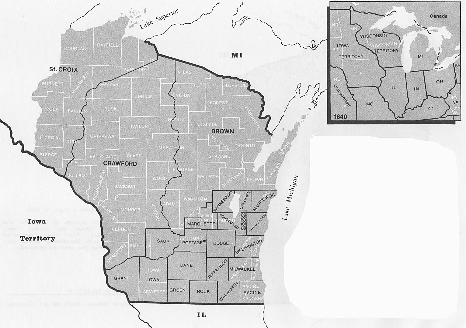
1840. WI Territory Federal Census. The map above shows in black the 22 counties of Wisconsin Territory at the time of the 1840 Federal Census. The current 72 counties of Wisconsin are shown in white. Wisconsin became a territory in 1836. The area of Wisconsin Territory in 1840 included the part of present Minnesota east of the Mississippi; the territory’s population was at 30,945 people. * Map Notes: Portage County was expanded northward in 1841, and in 1856, Portage assumed its present, modern bounds, having thus “migrated” completely north of its position shown on this 1840 map. The cross-hatched area was mistakenly overlooked by the Wisconsin laws in 1840 but is assumed to be part of Fond du Lac County. Map Source: Page 367, Map Guide to the U.S. Federal Censuses, 1790-1920, by William Thorndale and William Dollarhide.
1848. May 29. Wisconsin was admitted to the Union as the 30th state, with boundaries the same as today.
About Wisconsin’s Censuses
Wisconsin Territory Censuses were taken in the years 1836, 1838, 1842, 1846 and 1847. A few counties are missing from the 1846 territorial census, but the others are fairly complete. The WI territorial censuses are all head of household censuses. All surviving originals, 1836-1847, are located today at the WI Historical Society in Madison. WI Territorial Censuses Online: Ancestry’s Compiled Census & Census Substitutes database includes indexes to the 1836 through 1846 WI Territorial Censuses.
Wisconsin State Censuses: The state constitution of 1848 mandated state censuses every ten years for the purpose of apportionment of the state legislature. Accordingly, Wisconsin conducted state sponsored censuses for the years 1855, 1865, 1875, 1885, 1895, and 1905. Of these, the 1865 state census has only a handful of counties extant, while the others are mostly complete. All of the censuses 1855-1895 are head of household censuses, and they vary in content with added information, e.g., no. of males and females, no. of persons of foreign birth, deaf, dumb, blind, insane, etc. In the 1885 and 1895 state censuses, a special added list was prepared, giving the names of living war veterans. The only Wisconsin census to list the names of all family members was the 1905 state census. As the culmination of all Wisconsin territory and state censuses, it is in every way a detailed and useful genealogical tool, showing relationships, parent’s birthplace, etc. An every-name index to the 1905 state census was prepared by the State Historical Society, a card index organized by county. WI State Censuses Online: all of the surviving state censuses taken in Wisconsin have been digitized and indexed online (1855-1905 at FamilySearch.org; 1855 (index only), 1895 & 1905 at Ancestry.com).
Wisconsin Federal Censuses (federal copies), 1840-1940: The only federal census taken under the name Wisconsin Territory was in 1840, with all 22 counties extant and 30,945 people. After statehood in 1848, the 1850 through 1940 federal censuses for Wisconsin are complete for all counties (with the exception of the 1890, lost for all states).
Wisconsin Federal Censuses (state copies), 1850-1870: Adding to the superb array of territorial and state censuses available, Wisconsin also has the original state copies of its 1850, 1860, and 1870 federal censuses. These original schedules have not been microfilmed, but the WI Historical Society has prepared every-name indexes to each of their state copies.
Further Reading:
Wisconsin Censuses & Substitute Name Lists, 1685-2013 (Printed Book), Softbound, 85 pages, Item FR0307.
Wisconsin Censuses & Substitute Name Lists, 1685-2013 (PDF eBook), 85 pages, Item FR0308.
Online Wisconsin Censuses & Substitutes: A Genealogists’ Insta-Guide TM (Laminated), 4 pages, 3-hole punched, Item FR0411.
Online Wisconsin Censuses & Substitutes: A Genealogists’ Insta-Guide TM (PDF eBook), 4 pages, Item FR0412.