For many years, Bill Dollarhide’s Map Guide to American Migration Routes, 1735-1815 has been the go-to book for understanding migration in early America. Bill actually has three migration routes products. The book, and two Insta-Guides.
Family Routes Publishing is once again bundling the 3 items and discounting the price by 50%. Regularly $35.85, the price is just $17.93 for all three items
Click here to order the bundle.
Following are descriptions of the three separate guides.
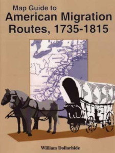
MAP GUIDE TO AMERICAN MIGRATION ROUTES, 1735-1815; by William Dollarhide; 8.5×11; perfect bound; b&w; Item # A0140
Family researchers need to locate and understand the early American migration routes their ancestors may have traveled. In this book, acclaimed author, William Dollarhide, shows these early roadways with well-researched and consistently drawn maps. Dollarhide’s guide begins with the King’s Highway of 1735 from Boston to Charleston and ends with the roads that resulted from the War of 1812 in the Old Southwest. These maps provide critical information for researchers trying to locate the passages of early migration in America.
The Following is from the Table of Contents:
- Preface
- Colonial Roads to 1750
- The Boston Post Road and the King’s Highway
- The Lancaster Road
- The Fall Line Road
- The Great Valley Road
- The Pioneer’s Road
- The Upper Road
- Colonial Roads, 1750-1775
- Braddock’s Road
- Forbes’ Road
- The Wilderness Road
- New York Migrations
- Roads to the Ohio Country
- Zane’s Trace
- The Nashville Road
- The National Road
- Roads to the Old Southwest
- The Natchez Trace
- The Federal Horse Path
- The Ways South After 1815
- Notes and References
- Index
Maps and Illustrations
- The King’s Highway
- Colonial Roads to 1750
- Braddock’s Road and Forbes’ Road, 1775-1758
- The Way West, 1775-1795
- New York Migrations
- State Land Cessions
- Ohio River Flatboat
- The Ohio Country 1787-1800
- The National Road, 1818-1838
- Principal Lines of the Old Southwest, 1797-1822
- New Orleans – Washington, 1806
- Indian Cession Dates in the Old Southwest
- The Ways South After 1815
These maps can be used as a method of understanding the places where ancestors may have passed or settled in route to their final destination, giving certain clues to where family records are kept today.
This book is invaluable for anyone doing colonial historical or genealogical research – and one that I would not be without!
COLONIAL WAGON ROADS INSTA-GUIDE
 It often began with a road.
“Genealogists need to know the places their ancestors lived before they will have any success in finding records for a person. Most documents naming a person are still located near the place the person lived, e.g. In a county courthouse, church, cemetery, or local funeral home. A big event in genealogical research is finding the county of residence for a person. To find the right county often means a researcher must understand the history of the area, when the county was first settled, and what roads were available for migrating families moving into the area.”
Not so surprising, many of today’s highways and byways follow the same path they did when first established, often as little more than a horse trail or wagon road. In Colonial Wagon Roads to 1750, author William Dollarhide provides a brief history of colonial roads that still exist today. This information is nicely packaged in the first Genealogists’ Insta-Guide™ from Family Root Publishing.
This Insta-Guide begins with a brief introduction along nice a table showing the colonial roads covered in this guide alongside their current highway designations. The bulk of the guide is broken into two sections. The first is the King’s Highway, broken into the five major section as it existed in 1750. The second group of roads comes under the banner Scots-Irish Influence on Road Building in Colonial America. There is another brief background followed by information on nine more major colonial roads. The guide is completed with a nearly full page map of these 1750 Colonial roads and a section for print and online references.
Like other quick sheets, and “at a glance” guides, the new Genealogists’ Insta-Guide series features four-page, laminated, colored guides which fit nicely into three-ringed binders and portfolios. By this design, these guides are easy to take along for sharing or going to the library for research; not to mention, they are easy to store. The Insta-Guide comes pre-punched for three-ringed insertion.
Contents
Introduction
Highway Table
King’s Highway
- 1750 King’s Highway – Boston to New York
- 1750 King’s Highway – New York to Philadelphia
- 1750 King’s Highway – Philadelphia to Alexandria
- 1750 King’s Highway – Alexandria to Norfolk
- 1750 King’s Highway – Norfolk to Charles Town
Scots-Irish Influence on Road Building in Colonial America
- Upper Post Road
- Hudson River Road
- Mohawk Road
- Lancaster Road
- Fall Line Road
- Great Valley Road
- Philadelphia Road
- Pioneer’s Road
- Upper Road
Map of 1750 Colonial Wagon Roads
Print References
Online References
Order Colonial Wagon Roads to 1750 from Family Roots Publishing; Price: $7.95.
AMERICAN MIGRATION ROUTES INSTA-GUIDE

American Migration Routes, 1750-1800 picks up where Colonial Roads to 1750 left off. As Colonial Roads indicated, many of today’s highways and byways follow the same path they did when first established, often as little more than a horse trail or wagon road. Much of the genealogical information family historians seek will be found in the towns and counties that lie along these roads. Travel in the 18th century, by today’s standards, was extremely slow. In many ways, people continued normal daily routines as they moved. It took time to cross territories. During this time children were born, illness and death happened, sometime people stopped to work or repair wagons, etc. Vital records were recorded and preserved in county courthouses, local churches, local cemeteries and funeral homes. These are the records genealogists seek. Knowing the roads and migration patterns will greatly help historians identify possible locations of these key vital records
This new Insta-Guide begins with a brief introduction along nice a table showing the various roads covered in this guide alongside their current highway designations. This guide is broken into four main sections: Roads to War, Proclamation Line of 1763, Manifest Destiny Begins, and Horse Paths to Turnpikes. Roads, policies, and historical insights provide a picture of these early byways. Dollarhide summarizes the best of his knowledge into a concise guide, which is as easy to read as it is insightful.
Like other quick sheets, and “at a glance” guides, the new Genealogists’ Insta-Guide series features four-page, laminated, colored guides which fit nicely into three-ringed binders and portfolios. By this design, these guides are easy to take along for sharing or going to the library for research; not to mention, they are easy to store. The Insta-Guide comes pre-punched for three-ringed insertion.
Contents
Introduction
Roads of War
- Braddock’s Road
- Forbes’ Road
Proclamation Line of 1763
Manifest Destiny Begins
Horse Paths to Turnpikes
- Wilderness road
- Ohio River (via Flatboats)
- Avery’s Trace & Nashville Road
- Cumberland Road
- Gist’s Trace
- Zane’s Trace
- Lancaster Pike
- Mohawk Turnpike
- Great Genesee Road
- Seneca Turnpike
Print References
Online References
Order A Genealogists’ Insta-Guide: American Migration Routes, 1750-1800 from Family Roots Publishing; Price: $7.95.