This article is by my good friend, William Dollarhide:
The following is based on information in the new Kentucky Name Lists book:
The original lands of Kentucky were inherited from Virginia when Kentucky became a state in 1792. The Kentucky Land Office was established soon after, acquiring record copies of all of the original Virginia land grants issued since 1774 in the area of old Fincastle County, Virginia. The Kentucky Land Office is still the keeper of the original land records and is a great resource for genealogical research in Kentucky. Information from the Kentucky Land Office webpage: “In Kentucky, land is allocated via the patenting process. The Kentucky Secretary of State’s office is the repository for all records pertaining to patents issued within the Kentucky boundary, including those issued by the state of Virginia prior to Kentucky’s statehood in 1792. This website contains searchable databases and information regarding military warrants issued for service in the French and Indian War, Lord Dunmore’s War and the Revolutionary War; non-military warrants and the resulting patents and a number of other databases. For additional information about Kentucky land records and related topics, please visit the Land Office’s Online Resources page, which houses materials that will aid researchers in their study of the Kentucky land patenting process and Land Office databases. If you would like to obtain copies of records maintained by the Land Office, please print and return or submit online a Land Office Order Form. Prepayment is not required; an invoice will be included when your order is returned to you. Please feel free to contact us about your research.” See the KY Name Lists book (page KY-6) for a screen print of the search form for Kentucky Land Patents. For the Land Office Contact Form, see
www.sos.ky.gov/admin/land/cities/Pages/Land-Office-Contact-Form.aspx.
Included in the new Kentucky Name Lists book (page KY-2), is a map and description of the last Indian Cessions of land within the present state of Kentucky.
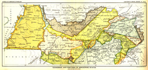
Indian Cessions – Tennessee & Kentucky, a part of Map No. 54, “Tennessee and Portions of Bordering States,” in Indian Land Cessions in the United States, compiled by Charles C. Royce, published by the Government Printing Office in 1899. To download the full map or find information about the text for the numbered cessions, see http://usgwarchives.net/maps/cessions/. The importance of understanding the areas and time periods of Indian Cessions in the U.S. is to know where and when it was possible for legal white settlement to take place. Although squatters were known to invade areas not yet ceded by the Indians, no one was permitted to purchase land until the area had been officially ceded by treaty with the various Indian tribes. Included on the map above are four numbered Indian Cession areas extending from Tennessee into Kentucky. Refer to the numbered cessions, Indian tribes, cession years, and descriptions of the areas below:
● Cession No. 3 (Cherokee, 1785), including the present towns of Nashville, Carthage, and Byrdstown, Tennessee; and Albany, Burkesville, and Monticello, Kentucky.
● Cession No. 55 (Chickasaw, 1805), an area between the Cumberland and Tennessee Rivers to the Ohio River, including a narrow stretch into Kentucky.
● Cession No. 57 (Cherokee, 1805), an area including the present towns of Waverly, McMinnville, Sparta, and Huntsville, Tennessee; to an area including Williamsburg and Pineville, Kentucky.
● Cession No. 100 (Chickasaw, 1818), the western parts of Tennessee and Kentucky lying between the Tennessee and Mississippi Rivers. The Tennessee portion included the present towns of Memphis, Dyersburg, and Paris, Tennessee; and the Kentucky portion included the present towns of Murray, Mayfield, and Paducah, Kentucky. Although the region was purchased by the U.S. Government, title to the land fell to the states of Tennessee and Kentucky, two state land states. The Tennessee portion of Cession No. 100 is simply called West Tennessee. The Kentucky portion of Cession No. 100, is referred to as The Jackson Purchase. In Kentucky, the Jackson Purchase included both military tracts and public tracts, as specified by the Kentucky General Assembly in 1820. The entire area was surveyed using the US Rectangular System with townships, ranges, and sections. The public land was then sold in quarter sections (160 acre parcels). The Jackson Purchase region was the only part of Kentucky not surveyed with the colonial Metes and Bounds system of land measurement it had inherited from Virginia in the 1770s.
For more information, see
Kentucky Name Lists: Published and Online Censuses & Substitutes, 1773-2000, by William Dollarhide.
Kentucky Name Lists (PDF)
Online Kentucky Name Lists, a 4-page laminated Insta-Guide
Online Kentucky Name Lists (PDF)