Many maps were created for the 2010 Census. One of these resources is the “Tribal Tract Reference Maps.”
The following is from the website:
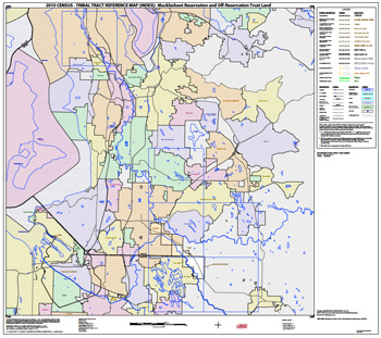
These federal American Indian reservation-based maps show and label tribal census tracts and tribal block groups as delineated to support 2010 Census data dissemination. These maps also show the boundaries and names of American Indian reservations, off-reservation trust lands (ORTLs), Alaska Native areas, Hawaiian home lands, states, counties, county subdivisions, and places. Additionally, these maps display a base feature network including roads, railroads, and water bodies. These features are labeled as map scale permits. Each entity is covered by one or more parent map sheets at a single scale. An index map showing the sheet configuration is included for all entities requiring more than one parent map sheet. The map sheet size is 36 by 32 inches.
Using the maps online, you will want to blow them up to 150% or so. I found most that I had an interest in came onscreen as a PDF at 25%. Having lived in Western Washington for 40 years, I have an interest in the Puyallup and Muckleshoot Indian reservations. Each of these reservations has 7 pdf maps available.
Thanks to Accessible Archives for posting an item on Facebook about these maps.