The following article was written by my good friend, Bill Dollarhide, and is taken from his book, Nebraska Censuses & Substitute Name Lists, 1854-2000.
Prologue: The highlighted events of this historic timeline for Nebraska are focused on the early settlements and jurisdictional changes that evolved. The goal here is to give genealogists a sense of the jurisdictions in place at the time an ancestor lived there. The Nebraska area entered the United States as part of the Louisiana Purchase of 1803. The earliest visitors came via the Missouri River, and later via the Platte River Trail across the entire length of the state.
1682. Louisiana. French explorer René-Robert Cavelier (Sieur de LaSalle) erected a cross near the confluence of the Mississippi River and the Gulf of Mexico, after floating down river from the Illinois Country. He claimed the entire Mississippi Basin for Louis XIV of France, for whom Louisiana was named.
1682-1720. Louisiana. During this period, the jurisdiction of Louisiana ran from the Gulf of Mexico to the junction of the Arkansas River with the Mississippi River. The French administered Arkansas Post, Natchez, Baton Rouge, New Orleans, Mobile, and Biloxi as part of Louisiana. Fort Louis de la Louisiane (now Mobile), was the capital of Louisiana, 1702-1720.
1720-1762. Upper and Lower Louisiana. By 1720, The Illinois Country was separated from Quebéc and added to Louisiana. The original Louisiana area became known as Lower Louisiana. The capital of Lower Louisiana was at New Orleans, 1720-1762. Upper Louisiana extended from the Highlands (Terra Haute) on the Wabash River down the Ohio and Mississippi Valleys to the Arkansas River. The fur trading settlements of Upper Louisiana included Vincennes (now Indiana), Prairie du Chien (now Wisconsin); Cahokia, Kaskaskia, Chartres, Saint Philippe, and Prairie du Rocher (now Illinois); Ste. Genevieve (now Missouri), and Fort de Chavagnial on the Missouri River (now Kansas).
1763. Treaty of Paris. This was the end of the French and Indian war. (In Europe it was called the “Seven Years War.”) At the 1763 treaty, the French surrendered all their claims in North America. Spain acquired the former French areas west of the Mississippi, renamed Spanish Louisiana. Great Britain gained all of Québec, which they immediately renamed the Province of Canada. Britain also gained control of the rest of North America east of the Mississippi River. They named their entire area British North America.
1783. Treaty of Paris. As the official end of the Revolutionary War, the 1783 treaty recognized the United States as an independent republic, with borders from the Atlantic Ocean to the Mississippi River. The treaty also reaffirmed the claims of Britain to present-day Canada; and Spain’s claim to lands west of the Mississippi River.
1800. Louisiana. Napoleon acquired title of Louisiana from Spain. At the Third Treaty of San Ildefonso, the Spanish acknowledged that it was too costly to explore the country and could not see the rewards being worth the investment. Spain retroceded Louisiana to France in exchange for the Grand Duchy of Tuscany (now part of Italy).
1803. Louisiana Purchase. The United States purchased Louisiana from France. Sent by President Jefferson to attempt the purchase of New Orleans, the American negotiators (James Madison and Robert Livingston) were surprised when Napoleon offered the entire tract to them. The Louisiana Purchase was officially described as the “drainage of the Mississippi and Missouri River basins.” Adding the area doubled the size of the United States.
1804. Lewis and Clark Expedition. Ordered by President Thomas Jefferson, Captains Meriwether Lewis and William Clark’s Corps of Discovery left St. Louis in search of a passage to the Pacific Ocean. Based on bad information from his spies, the Spanish governor of New Mexico dispatched soldiers from Santa Fe to the Arkansas River to intercept the party and arrest them. But, the Lewis and Clark party had taken a more northern route, following the Missouri River.
1804-1805. In 1804, Congress divided the Louisiana Purchase into two jurisdictions: Louisiana District and Orleans Territory. The latter had north and south bounds the same as the present state of Louisiana, but did not include land east of the Mississippi River, and its northwestern corner extended on an indefinite line west into Spanish Tejas. For a year, Louisiana District was attached to Indiana Territory for judicial administration, but became Louisiana Territory with its own Governor on July 4, 1805.
1812. Missouri Territory. On June 4th Louisiana Territory was renamed Missouri Territory by Congress This was to avoid any confusion after Orleans Territory became the State of Louisiana on April 30, 1812. The General Assembly of the Territory of Missouri met in St. Louis in October, and converted the first five original districts into counties: Cape Girardeau, New Madrid, St. Charles, St. Louis, and Ste. Genevieve. A year later, the territorial legislature created Arkansas County from lands ceded by the Osage Indians.
1812. Spaniard Manuel Lisa built Fort Lisa on the Missouri River near present Omaha. He was credited with establishing the earliest fur trading posts along the Missouri River, from Nebraska to Montana.
1819. Fort Atkinson. The U.S. Army established Fort Atkinson on the west side of the Missouri River (now the town of Fort Calhoun, Washington Co NE).
1820. U.S. Army Major Stephen Long explored the Platte and South Platte river routes of present Nebraska and into Colorado. His official U.S. Army report referred to the central plains as the “Great American Desert” and had the effect of diverting interest in the area for several years. Long’s report ignored the fact that over one million bison depended on the Nebraska Country for survival, and that the prairie had an abundance of fertile soil. Eighty years later, the Ogallala Aquifer, the largest aquifer in the world, began irrigating the “Great American Desert,” including the entire state of Nebraska.
1820. The Missouri Compromise in Congress allowed Missouri to enter the Union as a slave state and Maine as a free state, thus keeping the balance of slave and free states equal in Congress. The Act dictated that the remaining area of Missouri Territory north of Latitude 36° 30’ was to be free of slavery (that area included present Kansas, Nebraska, Iowa, Minnesota, North Dakota, South Dakota, Wyoming, and Montana).
1821. Aug 10th. Missouri was admitted as a state with St. Louis as the capital. After Missouri became a state, the remaining part of old Missouri Territory was officially described as Unorganized Territory. The entire region was inhabited exclusively by American Indian tribes, except for a few left-over French-Canadian voyageurs roaming the rivers.
1823. Bellevue (first named Fontenelle’s Post) became the first permanent settlement in Nebraska. The town is now a suburb of Omaha.
1827. Independence, Missouri. The frontier town of Independence was founded in 1827, the farthest point westward on the Missouri River where steamboats could travel at that time. Independence immediately became a supply point, staging area, and primary starting point for the growing number of trappers and traders using the Santa Fe Trail.
1829. Sublette’s Trace/Oregon Trail. Before 1829, access to the Platte River Trail from Independence, Missouri, was via the Missouri River to the mouth of the Platte River in present Nebraska. But steamboat traffic ended at Independence and travel up river at that time required human-powered keel boats. The overland route of the Santa Fe Trail now started at Independence as well, heading west several miles into present Kansas, then southwest towards Santa Fe. A few miles into the Santa Fe Trail in present Kansas, at a point later called the Oregon Trail Junction, fur trader William Sublette blazed a cut-off from the Santa Fe Trail, turning northwest and connecting with the Platte River in present Nebraska. The new route across present northeast Kansas was more direct than the river route, and later became the first leg of the Oregon Trail.
1832. After dredging projects near the mouth of the Kansas River, steamboat traffic could now continue up the Missouri River. In 1832, the steamboat Yellowstone began the first of its annual fur-trading voyages up the Missouri River, reaching Fort Union (near the present North Dakota/Montana line). More steamboats going up river saw the need for docking, loading, and refueling facilities, and the development of new river ports along the entire length of the Missouri River.
1842. Nebraska Country. The word “Nebraska” first began to appear in publications in 1842 after John C. Fremont explored the Platte Valley and present Nebraska areas.
1843. May. Oregon Trail. A wagon train with over 120 wagons, a large herd of livestock, and 1,000 pioneers left Elm Grove, MO and headed out on the Oregon Trail. The largest wagon train to date, it became the model for the thousands of wagon trains that followed. For an online list of the members of the 1843 Wagon Train, see the Oregon RootsWeb website.
1846. The Utah-bound Mormons sent work parties ahead of their wagon trains to plant crops in Nebraska a year before the main body of immigrants passed through. This was when Nebraska was first discovered to be a great place to grow things.
1849. The onset of the California Gold Rush was when Nebraska was discovered as the best way to get there. A natural wagon route across the entire length of present Nebraska was the Platte River Trail (aka Oregon Trail, Immigrant Trail, or Mormon Trail).
1852. In this one year, over 250,000 people passed through Nebraska en route to California and Oregon. Few stopped for any length of time, because the area was not legally open for settlement yet.
1854. Nebraska Territory was created in 1854 as part of the Kansas-Nebraska Act, landmark legislation relating to free versus slave states prior to the Civil War. The Act authorized the first land surveys west of the Missouri River, opening both territories for settlement. Both Kansas and Nebraska were expected to vote on the slavery issue, and both territories immediately began taking annual censuses to number and identify (by name) their qualified voters.
– Beginning in 1854, A large portion of eastern Nebraska Territory was surveyed for public land sales. The first federal General Land Offices (GLOs) were established at Brownsville, Dakota City, Nebraska City, and Omaha City. After the first year of land sales, about 4,500 people had settled in Nebraska Territory.
1854-1865. Nebraska Territory Censuses. The first three territorial censuses were taken in 1854, 1855, and 1856. They were heads of households name lists covering the eastern half of present-day Nebraska. The first three census years are mostly complete for all counties in place at the time. The fourth (and last) territorial census was taken in 1865, but only two full county name lists survive today. The originals of all surviving territorial census schedules are located at the Nebraska State Historical Society (NSHS) in Lincoln.
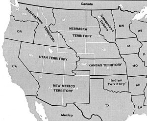
1860. Western United States at the time of the 1860 Federal Census: In 1854, Nebraska Territory and Kansas Territory were created from the old Unorganized Territory. Both new territories extended west of the Missouri River to the Continental Divide. The only remaining area within the Unorganized Territory was unofficially called “Indian Territory” (now Oklahoma). The 1860 Census of both Kansas and Nebraska Territories included a good number of people looking for gold in present Colorado. The Denver area was in the KS census, the Boulder area was in the NE census. “Unorganized Dakota” was a label invented by the Census Office. For convenience, several forts and posts along the Missouri and Yellowstone rivers were enumerated as part of Unorganized Dakota, even though they were technically located within Nebraska Territory.

1860. Nebraska Territory. On the above map, the county names and lines in white are for the modern boundaries of Nebraska. Those in black are for the 1860 territorial boundaries. People enumerated in the 1860 census outside of the modern Nebraska area were limited to Fort Randall, in present South Dakota; and Boulder, Altoona, and other northeastern Colorado towns enumerated as the Unorganized area west of 101° 30’and south of 42°. *Note: County name changes are not explained here, except note that by 1870 the name Nuckolls had been moved west one county.
1863. During the Civil War, and towards the end of President Abraham Lincoln’s first term in office, the Lincoln administration promised a quick approval to any proposed state constitution submitted from Nebraska Territory. Lincoln saw the strong Union support of Nebraska Territory as a way to ensure enough votes for reelection, but only the residents of states had the right to vote. Lincoln made the same offer to Nevada Territory and Colorado Territory. Only Nevada took up his offer, becoming a state two weeks before the presidential election of 1864. Both Nebraska and Colorado took the matter to their territorial legislatures in 1863, and both rejected statehood as “premature.”
1867. Mar. Nebraska Statehood. Two years after the end of the Civil War, Nebraska joined the Union as the 37th state, with Omaha as the capital until a year later, when Lincoln was chosen.
1869-1884. Nebraska State Censuses. After statehood in 1867, the Nebraska legislature passed a law that called for annual censuses, including lists of births and deaths to be gathered by the county tax assessors. It is not known how diligent the counties were in complying with the law, and only a few of the county census name lists have survived. The NSHS has some original annual name lists for 1869-1870, 1874-1879, and 1882-1884, but for just a few counties.
1885. Nebraska State Census. The Nebraska state census law was repealed in 1885. In that year, the Federal Government offered any state or territory an option for an assisted state census, providing federal money to help defray the cost. Nebraska was one of only five states or territories that took up the offer. An 1885 state census of Nebraska was completed using a similar format as the 1880 federal census. The 1885 proved to be the last state census in Nebraska, and stands complete for all counties in place in 1885, except for one missing county (Chase). Nebraska’s original state copy of their 1885 census was lost – but as part of the deal with the Federal Government, a transcription copy had been made and sent to Washington, DC. That copy was microfilmed by the National Archives.
Further Reading:
Nebraska Censuses & Substitute Name Lists, 1854-2000 (Printed Book), 2017, softbound, 81 pages, Item FR0263.
Nebraska Censuses & Substitute Name Lists, 1854-2000 (PDF eBook), 2017, 81 pages, Item FR0264.
Online Nebraska Censuses & Substitutes: A Genealogists’ Insta-Guide™, 4-page, laminated, 3-hole punched, Item FR0333.
Online Nebraska Censuses & Substitutes: A Genealogists’ Insta-Guide™ (PDF version), 4-page, Item FR0334.