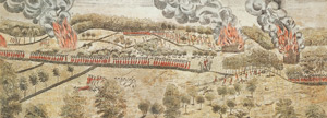
Using 21st-century equipment, archeologists are now mapping out exact spots British soldiers and Colonial militiamen were stood as they shot at each other on a rocky hillside on the border of Lexington and Lincoln the first day of the American Revolution.
“Parker met a force approximately 10 times his size and took 20 percent casualties on the green, then made the choice to go after them,” said Bob Morris, president of the nonprofit Friends on Minute Man National Park. “It’s the kind of heroism that cries out to be researched and memorialized.”
The 44-acre Parker’s Revenge battle site is completely within the Minute Man National Historical Site. They have located both unspent and fired musket balls, and even found a button that has a fox, a windmill, and a bridge on it!
Read much more about the project in an AP article posted September 30, 2015 at the FoxNews.com website.