The following article is by my good friend, Bill Dollarhide, taken from his book, New Mexico Censuses & Substitute Name Lists, 1600-2010
Prologue: This historical timeline is related to New Mexico, beginning with the early Spanish claims and settlements along the Rio Grande; and continuing up to the time of New Mexico’s statehood in 1912, as follows:
1536. Spanish explorer Cabeza de Vaca entered present New Mexico via the Rio Grande valley. He was the first Spaniard to repeat the story of the Seven Cities of Cibola (or Seven Cities of Gold) he had learned about from the local Indians. The Indians perpetuated the rumor, always telling the Spaniards that the cities of gold were just a little further away. This ploy worked for 60 years, keeping the Spanish soldiers from staying long in one place.
1539. Franciscan friar Marcos de Niza and companion Esteban explored present New Mexico and Arizona looking for the Seven Cities of Cibola. They reached the Zuni village of Hawikuh where Esteban was killed.
1540. Francisco Vasquez de Coronado of Spain came searching for the Seven Cities of Cibola. Coronado never found the cities of gold, but did find the Gulf of California, Colorado River, Grand Canyon, and the Arkansas River Valley areas of Colorado and Kansas. He claimed the entire region as part of New Spain.
1590. The first attempt to colonize Nuevo Mexico was made by conquistador Gaspar de Sosa, who led a party of some 170 settlers into the Pecos River Valley. De Sosa was infamously known for the numbers of natives he captured and sold into slavery.
1598. Juan de Oñate founded the first permanent Spanish colony at San Juan de los Caballeros (near present-day Espanola, New Mexico). San Juan became the capital oft he Province of Nuevo Mexico.
1600. San Gabriel was founded at the confluence of the Rio Grande and Chama Rivers. San Gabriel became the new capital of Nuevo Mexico. Lists of settlers living in Nuevo Mexico exist for as early as 1600. Microfilm of the Seville originals are at the New Mexico State Archives in Santa Fe.
1609. Santa Fe de Nuevo Mexico. Governor Pedro de Peralta founded Santa Fe as the final capital, and renamed the Spanish province as Santa Fe de Nuevo Mexico.
1680. The Pueblo Indians revolted and drove the Spanish out of northern Nuevo Mexico, who fled to El Paso del Norte.
1693. Diego de Vargas conquered Nuevo Mexico (again) for Spain.
1743. French Louisiana traders from Arkansas Post (near the Mississippi River) reached Santa Fe and initiated trade with the Spanish colonists. The route they blazed to get there became part of the Santa Fe Trail.
1750. A Spanish census taken in 1750 exists for Albuquerque, Belen, Santa Fe, and Valencia. Microfilm of the Seville originals are at the New Mexico State Archives in Santa Fe.
1776. A route from Santa Fe to Los Angeles was explored, later known as the Old Spanish Trail.
1790. A Spanish census for Santa Fe and Taos survives. Microfilm of the Seville originals are at the New Mexico State Archives in Santa Fe.
1800. The Spanish colonial population of Santa Fe de Nuevo Mexico had reached about 20,000 people.
1804. Hearing of a supposed intrusion of Americans into their territory, Spanish troops were dispatched from Santa Fe to intercept the Lewis and Clark Expedition, but failed to find them.
1807. U.S. Army Captain Zebulon Pike led the first American expedition into the Rocky Mountains and returned via Nuevo Mexico. Pike’s published book reporting his expedition was the first written English description of the Rocky Mountains, as well as descriptions of the Spanish culture in North America, and became a best seller in North America and Europe. The book was also the inspiration and guide to a great number of Mountain Men, the only non-Indian residents of the Rocky Mountain region for another twenty-five years.
1821. Mexico gained independence from Spain and exerted military control of the provinces of Santa Fe de Nuevo Mexico and Coahuila y Texas. That same year, merchants and traders from the United States come into the area via a route called the Santa Fe Trail.
1829. The first commercial caravan along The Old Spanish Trail from Santa Fe to Los Angeles was led by Mexican trader Antonio Armijo. He is best known for naming an artesian spring oasis in the desert as Las Vegas (The Meadows).
1830. A Mexican census for Santo Domingo is extant. The originals are located at the New Mexico State Archives in Santa Fe.
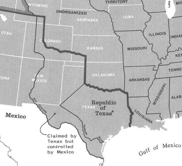
1836. Texas Claim. As a province of Mexico, the southwestern border of Coahuila y Texas was along the Nueces River and an extended line to the southeast corner of present New Mexico. The border was extended by the new Republic of Texas in 1836, from the Nueces to the Rio Grande, thus adding eastern New Mexico and areas into present Colorado. Although claimed by Texas, the extended area was never occupied by Texas. Map source: Map Guide to the U.S. Federal Censuses, 1790-1920.
1839. A Mexican census for Valencia exists, the originals are at the New Mexico State Archives in Santa Fe.
1841. Texas troops invaded present New Mexico areas along the Rio Grande, attempting to possess their claim to the area, but the Texas troops were held at bay by Mexican forces.
1845. Texas was annexed to the United States as the 28th state. The U.S. wanted to acquire the Texas Claim to the Rio Grande, but Mexico warned that a war would result from such an action.
1846. Feb. The U.S. officially made an offer to Mexico to purchase the area of the Texas Claim. Mexico rejected the offer.
1846. Apr. Mexican-American War. U.S. Forces quickly took control of the Rio Grande Valley. The captured area from the old Texas line to the Rio Grande was annexed to the United States, based on the acquired Texas Claim.
1846. Dec. A Provisional New Mexico Territory was organized by U.S. Army General Stephen Kearny. The provisional territory operated until the official New Mexico Territory was created by Congress in 1850.
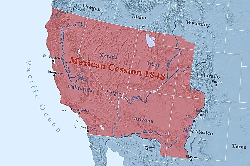
1848. Mexican Cession. As part of the Treaty of Guadalupe Hidalgo ending the war with Mexico, the United States gained ownership to the remainder of New Mexico west of the Rio Grande, including most of present Arizona; a portion of western Colorado; part of southwestern Wyoming; and all of present California, Utah and Nevada. In compensation, the U.S. paid Mexico a sum of 18 million dollars for an area which was nearly half of the Republic of Mexico, and was comparable in size to the Louisiana Purchase. The Provisional Territory of New Mexico now extended from Texas to California. Map source: Wikipedia.
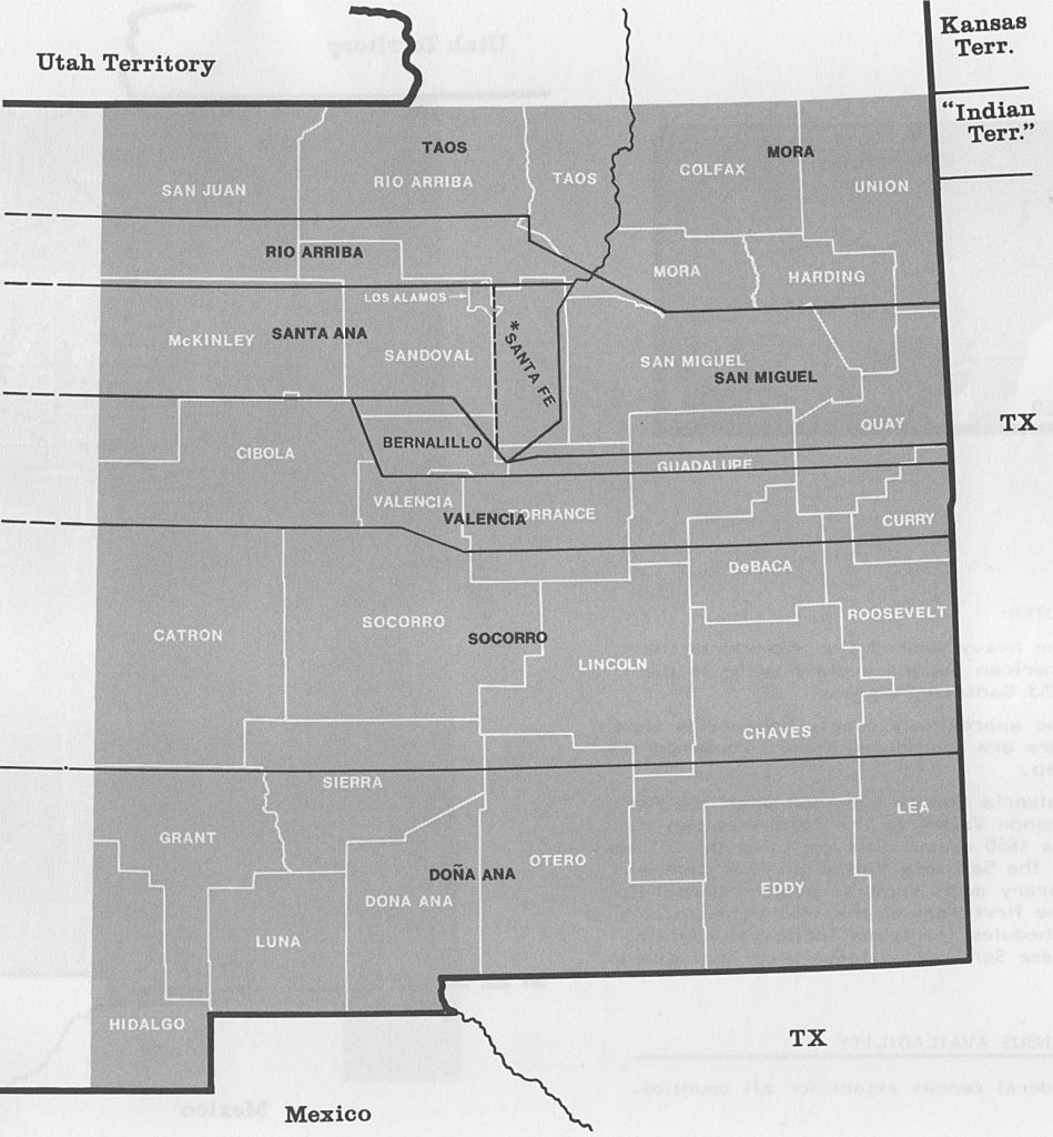
1850. June. Federal Census. The provisional Territory of New Mexico was included in the 1850 census, with the original seven counties of Bernalillo, Rio Arriba, Santa Ana, Santa Fe, San Miguel, Taos, and Valencia counties. Taos County included an area of all or part of 13 modern Colorado counties. The area of present Arizona north of the Gila River was also part of New Mexico Territory, but no population was enumerated there.
1850. Sept 9th. California was admitted to the Union as the 31st state; and on the same day, Congress established both Utah Territory and New Mexico Territory.
1852. Doña Ana County was established, stretching across the southern portion of New Mexico Territory, well into the area that later became Arizona.
1853. Gadsden Purchase. Seeking access for a southern railroad route, the U.S. paid Mexico a sum of 10 million dollars to purchase a 45,000 square mile tract of land south of the Gila River. The purchase was negotiated by James Gadsden, minister to Mexico. The entire area of the Gadsden Purchase was added to New Mexico Territory, which immediately expanded Doña Ana County to administer the newly acquired area.
1857-1861. Butterfield Overland Stagecoach. Beginning in 1857, the Butterfield Overland Mail Co. held the U.S. Mail contract for service from either St. Louis or Memphis to San Francisco. The first part of the routes converged on Fort Smith, AR, then through Indian Territory to points including Fort Worth and El Paso, TX; and on to Santa Fe, New Mexico Territory. From Santa Fe to Los Angeles, the Butterfield route followed the same general trace as the Old Spanish Trail, passing through Tucson and Fort Yuma, en route to Los Angeles; and then up the Central Valley of California to San Francisco. For nearly three years, two Butterfield stages per week made the trip, one leaving Memphis each Monday and St. Louis each Thursday. From San Francisco, Butterfield stages departed each Monday and Thursday. The trip would take at least 22 days and sometimes up to 25 days to complete. The Butterfield southern mail service was discontinued upon the start of the Civil War, replaced by the Central Stage Route in 1861. The Butterfield operation was taken over by the Wells Fargo Co in 1866.
1859. New Mexico Territory created Arizona County from Doña Ana, within the Gadsden Purchase area of present Arizona south of the Gila River.
1860. Federal Census. New Mexico’s population of 93,516 people was enumerated in areas of present southern Colorado, and all of present Arizona and New Mexico. Arizona’s enumeration was in Arizona County, New Mexico Territory, including the few settlements just north of the Gila River; plus Fort Mojave on the Colorado River, technically in New Mexico’s Valencia County. Map Source: Map Guide to the U.S. Federal Censuses, 1790-1920.
1861. Confederate troops from Texas invaded and occupied New Mexico Territory, mostly the settlements along the Rio Grande Valley, but also as far west as Tucson.
1861. The Territory of Colorado was created by the U.S. Congress. New Mexico lost the northern-most parts of Taos and Mora counties to the new territory.
1861-1862. The Confederate Territory of Arizona was declared by the Confederate Congress with the capital at La Mesilla. The area of the Confederate Territory of Arizona was a southern swath of the original New Mexico Territory on a horizontal line running from Texas to California.
1862. April. The battle of Velvarde and Glorieta Pass was fought to a stalemate, but soon after, the Confederate armies retreated from New Mexico, and the Confederate Territory of Arizona disappeared. However, Confederates troops did not leave Tucson until 1863.
1862. Arizona County, New Mexico Territory was abolished, its area returned to Doña Ana County.
1863. Arizona Territory was created by the U.S. Congress, with Prescott as the first capital. The area of New Mexico Territory was reduced to its present size and shape. Arizona Territory was created during the Civil War, and after the demise of the Confederate Territory of Arizona, the combined Confederate/Union area was managed by a military governor for two years. The northern boundary of Arizona Territory extended west to the California line, and included all of present Clark County, Nevada. When Congress divided New Mexico Territory on the same meridian as Colorado’s western line, the resulting map created the “four corners” of Colorado, Utah, Arizona, and New Mexico, the only point in the U.S. where four states meet at a quadripoint.
1870. Federal Census. New Mexico Territory’s population was at 91,874.
1880. March. The Southern Pacific Railroad reached Tucson, Arizona Territory, completing the route from Los Angeles. The Southern Pacific had purchased a railroad running from the Atlantic Coast to Texas, and was now starting the connection from Arizona Territory to Texas.
1880. June. Federal Census. New Mexico Territory’s population was at 119,565. After microfilming, the National Archives gave away the original 1880 census schedules for New Mexico Territory (3 vols.). In the 1950s, they were first located at the DAR Library in Washington, DC., but recent inventories there show the NM 1880 originals may have been later moved (to New Mexico?).
1881. October. With the completion of the leg from Tucson, Arizona Territory to Santa Fe, New Mexico, and on to Sierra Blanca, Texas, the Southern Pacific Railroad became the second transcontinental railroad.
1885. June. A New Mexico territorial census was taken with federal assistance, the only territorial or state census in New Mexico.
1912. Jan 6. New Mexico became the 47th state, with Santa Fe as the state capital.
Further reading:
New Mexico Censuses & Substitute Name Lists, 1600-2010 (Printed Book), softbound, 87 pages, Item FR0271.
New Mexico Censuses & Substitute Name Lists, 1600-2010 (PDF eBook), 81 pages, Item FR0272.
Online New Mexico Censuses & Substitutes: A Genealogists’ Insta-Guide™, laminated, 4-pages, 3-hole punched, Item FR0431.
Online New Mexico Censuses & Substitutes: A Genealogists’ Insta-Guide™, (PDF version), 4-pages, Item FR0342.