The following article was written by my good friend, by William Dollarhide:
The study of Michigan’s early American history includes the Indian Land Cessions, and subsequent public land sales in Michigan Territory. Twenty State Land States each held the original title to their unsold lands at the time they entered the Union. Michigan was one of the thirty Public Land States, where public land sales were conducted by the federal government. Michigan began as part of the first Public Domain of the U.S. – the Northwest Territory. Title to all of the land in the Public Domain fell to the federal government, including responsibility for purchasing the land from the American Indians via treaty. Only then was land sold to the public. Public land was sold only in a General Land Office (GLO) which the federal government sited near the land being sold. The first Indian Land Cessions in Michigan Territory began in 1807. Following the series of Indian land Cessions reveals the areas and time periods when white settlement could legally take place. The other states formed from the Northwest Territory had an impact on the evolvement of Michigan as well. And, an identification of the early federal and state censuses taken in Michigan aids in the understanding of the steady growth in the early days of its settlement. Along with these highlighted events, this historical timeline of Michigan identifies the main jurisdictions and how they evolved. The goal here is to give genealogists a sense of the jurisdictions in place at the time an ancestor lived in Michigan. Understanding the jurisdiction where the records may be located today is half the battle in genealogical research.
1612-1615. French explorers Etienne Brule and Samuel de Champlain were the first Europeans to see the Great Lakes. Brule explored Lake Huron in 1612. He was followed by Champlain in 1615.
1668-1671. In 1668, French missionary Fathers Claude Dablon and Louis Marquette established the first permanent European settlement in present Michigan at Sault Sainte Marie. The same two established a mission at Mackinac Island in 1670; another at St. Ignace in 1671.
1673. French explorers Jacques Jolliet and Louis Marquette left their base in St. Ignace and made their way to the Illinois River, which they descended to become the first Europeans to discover the Mississippi River.
1679. French missionary Louis Hennepin sailed up the Detroit River, through Lake St. Clair, which he named, and into Lake Huron and Lake Michigan. Hennepin was associated with Rene-Robert Cavelier (Sieur de La Salle), the first governor of Québec, and with whom he had built the 45-ton ship, Le Griffon, to sail through the Great Lakes.
1682 Louisiana. Following the same route as Jolliet and Marquette, René-Robert Cavelier (Sieur de LaSalle) floated down the Mississippi River and continued all the way to its mouth at the Gulf of Mexico. He then claimed the entire Mississippi Basin for Louis XIV of France, for whom Louisiana was named.
1685. The French established La Louisiane Française as a district of New France. The French claims in North America now included all of the present Maritime Provinces, the St. Lawrence River areas, the Hudson’s Bay areas, the Great Lakes areas, and the entire Mississippi Basin.
1691. Fort St. Joseph (now Niles, Michigan) was established by the French as a military and trading post.
1701. French Acadian explorer and adventurer Antoine de la Mothe Cadillac established Fort Ponchartrain du Détroit for France on the site of present Detroit, Michigan. The Wyandot Indians (named the Huron Indians by the French) allowed the fort to be built and occupied in exchange for trade goods offered by the French traders.
1713. Queen Anne’s War. At the Peace of Utrecht ending the war, France ceded to Britain its claims to the present Hudsons Bay region and the peninsula part of French Acadia (which the British renamed Nova Scotia). The remaining French claims in North America were now contained within Quebéc, including the St. Lawrence River and Great Lakes region; and La Louisiane Française, which extended down the Ohio and Mississippi Rivers to the Gulf of Mexico.
1758-1760. In 1758, during the French and Indian War, the British captured Fort Frontenac (present Kingston, Ontario), the strategic access point to the Great Lakes. In 1760, British Army Major Roger Rogers took possession of Fort Detroit in the name of Great Britain, ending French rule there.
1763. The Treaty of Paris of 1763 ended the French and Indian War (it was called the Seven Years War in Canada and Europe). France lost virtually all of its remaining North American claims. The original French areas east of the Mississippi and all of Acadia and Québec were lost to Britain; the areas west of the Mississippi went to Spain, renamed Spanish Louisiana. After the 1763 Treaty, George III issued a proclamation renaming the Province of Québec as the Province of Canada. He also issued the Proclamation Line of 1763, in which Indian Reserves were established west of the Appalachian Mountain Range, limiting western migrations by all of the British colonies. As part of the 1763 treaty, Britain was given the right to remove the entire Acadian population, either returning them to France, or finding other places in North America. The British agreed to provide the transplanted Acadians with land and assistance in a new settlement. Eventually, most of the removed Acadians ended up in Spanish Louisiana, just north of New Orleans.
1763. Pontiac’s Rebellion. During the French and Indian War, the Indian Tribes of the Great Lakes region supported and fought for the French. After the defeat of the French, the Ottawa Indians, led by Chief Pontiac, revolted against the British, taking possession of Fort St. Joseph, and all other trading posts and forts in present Michigan except Detroit.
1765-1773. American Rebellions. In 1765, the Stamp Act led to the formation of an anti-British group in Boston called the Sons of Liberty. In 1767, the Townshend Acts created a series of protests, led by the Sons of Liberty. In 1770, the Boston Massacre fueled the fires of rebellion, and in 1773, the Boston Tea Party in Boston Harbor protested the British tax on tea. The British Parliament responded with the Coercive Acts, taking away the right of self government in the colonies; and planting an occupation force of British Army Regulars in Boston.
1774. The Québec Act. The British reacted to the increased American rebellions by solidifying British loyalty in the Province of Canada. They enacting the Québec Act, which reversed the long-standing British policy against Catholic governments in all of their colonies. The Québec Act, just a few years after the forced deportations of Catholic French Acadians, restored the name Province of Québec and granted Québec residents full British citizenship, allowed them to retain their Catholic churches and parish taxing systems, and to keep their established French Laws and Customs. The Act also expanded the physical area of Québec to include a huge area of western lands claimed by the Thirteen Colonies; including present Michigan and the rest of the Old Northwest area. The Thirteen Colonies viewed the Québec Act as one of the Intolerable Acts that made the impending war justifiable.
1777-1778. During the Revolutionary War, a number of French-speaking Acadians from Spanish Louisiana joined their counterparts from the leftover French settlements of Kaskaskia, Vincennes, Sault Sainte Marie, and Mackinac Island. They were added to the Virginia Militia force commanded by General George Rogers Clark. General Clark later noted that the fiercely anti-British fighters he gained from the French communities contributed greatly to his monumental victories against the British in the conquest of the Old Northwest. But General Clark was never able to lead an expedition against Fort Detroit, which remained under British control for several years after the Revolutionary War.
1780-1783. Fort St. Joseph. During the war, the British army used Fort St. Joseph to equip and train their Indian partners in the Great Lakes region. In 1780, Fort Joseph was raided by a combined American/French force, but the attack was repelled by the British/Indian occupants. In 1781, a Spanish/Indian force left St. Louis and marched to Fort St. Joseph, defeated the British and took possession of the fort. The Spanish flag was raised and for a brief time, Fort St. Joseph was considered Spanish territory. Although the Spanish had declared war against Britain in 1780 in support of the American rebellion, their victory at Fort St. Joseph in 1781 was their only military campaign against the British during the Revolutionary War. After the war ended in 1783, the Spanish abandoned Fort Joseph, but it was not ceded by the British to the Americans until 1796.
1783. The Treaty of Paris of 1783 officially ended the Revolutionary War and recognized the United States of America as an independent nation for the first time. The area of present Michigan was included in the area defined to be part of the territory of the United States, but certain trading posts and forts in the Old Northwest region were still occupied by the British Army, including Prairie du Chien, Isle Royale, and Fort Detroit.
1784. Connecticut, Virginia and Massachusetts relinquished their western claims to lands in the Great Lakes region, a large area that was to become the Northwest Territory. Title of the state’s claims were transferred to the “Public Domain” of the United States Federal Government.
1787. Northwest Territory. The Ordinance of 1787 established the Territory Northwest of the River Ohio, and defined the procedure for any territory to obtain statehood. The first territory of the United States included the area of the present states of Ohio, Indiana, Illinois, Michigan, Wisconsin, and that part of Minnesota east of the Mississippi River.
1790. Federal Census. The Northwest Territory was specifically left out of the 1790 enumeration. Most of the white population in present Michigan was in or around Fort Detroit, still under control of the British Army. There were a few leftover French fur trappers and traders at Sault Sainte Marie and Mackinac Island.
1796. Jay Treaty. Under terms negotiated in the Jay Treaty, Fort Detroit and Fort Joseph were officially ceded by Britain to the United States.
1796. Wayne County, Northwest Territory was created. The area extended from present northern Ohio, and included the eastern half of the Lower Peninsula of present Michigan. Except for the Fort Detroit area, the part of old Wayne County within present Michigan was unceded Indian lands. In 1800, Indiana Territory was created and old Wayne County in present Michigan disappeared; later it was designated as unorganized territory. The current Wayne County, Michigan was formed in 1815.
1800. Indiana Territory was established from the Northwest Territory with William Henry Harrison as the first Governor and Vincennes the capital. The area included most of present-day Indiana, Illinois, Wisconsin; part of Minnesota, and the western half of Michigan. The Northwest Territory was reduced to the present-day area of Ohio and the eastern half of Michigan.
1803. Ohio was admitted to the Union as the 17th state, with Chillicothe as the state capital. The portion of present Michigan included in the Northwest Territory, 1800-1803, was added to Indiana Territory. Upon Ohio’s statehood, the name Northwest Territory was dropped.
1805. Michigan Territory was created, taken from the Indiana Territory. The original area was between Lake Michigan and Lake Huron, as today, but included only the eastern tip of the Upper Peninsula, the rest was under control of Indiana Territory. The territorial capital was at Detroit.
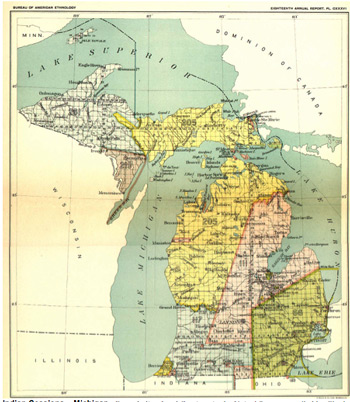
1807. Treaty of Detroit. This was the first large Indian Land Cession in Michigan Territory, involving the Ojibwa/Ottawa, Chippewa, Wyandot, and Potawatomi Indian tribes. The cession area extended from Lake Erie, included Detroit and north to Lake Huron below Saginaw Bay. The north-south trace of the western treaty line became the Michigan Meridian used in surveying all Michigan lands after 1815. Note: See Cession No. 66 (Green) on the MI Indian Cessions Map. (Link to map?)
1809. Illinois Territory was separated from Indiana Territory, with Kaskaskia the capital. The original area included present-day Illinois, Wisconsin, a portion of the Upper Peninsula of present Michigan and that portion of Minnesota east of the Mississippi River. The area of Indiana Territory was reduced in size to the area of the present-day state, plus a portion of the Upper Peninsula of present Michigan.
1810. Federal Census. Michigan Territory was the same as when it was created in 1805, with bounds within the Lower Peninsula plus just the eastern tip of the Upper Peninsula. There were four civil districts: Michillimackinac, Huron, Detroit, and Erie. Only fragments of the census schedules from Michillimackinac and Detroit have survived. The population in Michigan Territory in 1810 was 4,762 people.
1810 NOTE: The four civil districts of Michigan Territory in 1810 served as the means of enumerating the residents, and little else. Michillimackinac had only a population from the leftover French settlements at St. Ignace, Mackinac Island, and Sault Sainte Marie. Of the four civil districts of 1810, Michillimackinac was the only one that became an actual county with the same name (now Mackinac). The other three civil districts of Detroit, Huron, and Erie, were within the area of the 1807 Treaty of Detroit land cession. Those three civil districts were merged together to become a new Wayne County in 1815, the first actual county formed in Michigan Territory. In 1810, there was one General Land Office (GLO) in Michigan Territory, located at Detroit. The sale of public lands was limited to the area ceded by the Indians in the 1807 Treaty of Detroit. For the area of the 1807 Treaty of Detroit, see Cession No. 66 (Green) on the MI Indian Cessions Map. (link to map?)
1812-1814. At the beginning of the War of 1812, British forces captured both Fort Mackinac and Fort Detroit. After decisive victories by American forces in the Battle of Lake Erie and the Battle of the Thames, both Mackinac Island and Fort Detroit were returned to American control. The Fort Detroit campaign was led by General William Henry Harrison, who emerged as a national hero.
1816. Indiana was admitted to the Union as the 19th state, with the same boundaries as today. The portion of Indiana Territory in the Upper Peninsula became Unorganized Territory.
1817. An international commission for U.S. / British boundary disputes settled on the St. Mary’s River as the International Boundary between the U.S. and British North America, dividing the community of Sault Sainte Marie. The original community is now within the present Sault Sainte Marie, Michigan; and across the St. Mary’s River as Sault Sainte-Marie, Ontario.
1818. Illinois was admitted to the Union as the 21st state, with the same boundaries as today. The northern portion of Illinois Territory was reassigned to Michigan Territory. At the same time, the unorganized lands which had been part of Indiana Territory were also added to Michigan Territory.
1819. Treaty of Saginaw. This was a major Indian Land Cession in Michigan Territory, involving the Chippewa, Ojibwa/Ottawa, and Potawatomi tribes. Over six million acres of land was ceded to the U.S. federal government. The cession area began at the Treaty of Detroit line to a point near present Kalamazoo, then running northeast to Thunder Bay, encompassing all of Saginaw Bay, then back to the Treaty of Detroit line. Soon after the Treaty of Saginaw cessions, new U.S. government surveys were done in the ceded area. In 1820, there was just one GLO in Michigan Territory, located in Detroit. The first public land entries were in Monroe, Wayne, Macomb, and Oakland counties. Note: See Cession No. 111 (Pink) on the MI Indian Cessions Map. (link to map?)
1820. Federal Census. Michigan Territory now reflected the new areas obtained from Indiana and Illinois territories in 1818. The expanded territory included the Lower Peninsula and Upper Peninsula of present Michigan; plus all of present Wisconsin, and that part of present Minnesota east of the Mississippi River. The 1820 census in present Michigan was limited to areas ceded by the Indians within Monroe, Wayne, Macomb, and Oakland counties, all counties with extant census schedules. Michigan Territory created two counties in present Wisconsin in 1818: Crawford County, with an 1820 census taken for Prairie du Chien; and Brown County, with an 1820 census taken for Green Bay. Crawford and Brown became original counties of Wisconsin Territory in 1837. Michigan Territory’s Upper Peninsula counties of Michillimackinac and Chippewa were almost entirely within unceded Indian lands. Exceptions with populations were at St. Ignace, Mackinac Island and Sault Sainte Marie. The population of Michigan Territory in 1820 was 8,896 people.
1821. Treaty of Chicago. This was a major Indian Land Cession in Michigan Territory, involving the Ottawa, Ojibwa/Chippewa, and Potawatomi Indian tribes. The cession area included much of the land in Michigan Territory south of the Grand River. Note: See Cession No. 117 (Light blue) on the MI Indian Cessions Map. (link to map?)
1825. October. Erie Canal. The entire route of the Erie Canal, from Albany to Buffalo, New York opened to boat traffic for the first time. It was now possible to arrive at New York harbor by sailing ship, travel up the Hudson River by steamboat, and take the same towed barge from Albany all the way to Lake Erie. Steamboat access to the Great Lakes ports in present Ohio, Michigan, and Wisconsin followed. The impact of the migrations via the Erie Canal into Michigan contributed greatly to a population that jumped from under 10,000 in 1825 to over 210,000 in 1840.
1827. Michigan Territorial Census. The territory took its first territorial census in 1827. Surviving original name lists are available for Washtenaw County only.
1830. Federal Census. The area of Michigan Territory was unchanged from 1820. The census included Crawford, Brown, and Iowa counties of the Wisconsin area; Chippewa and Michillimackinac of the Upper Peninsula; and the Lower Peninsula counties of St. Clair, Oakland, Macomb, Wayne, Washtenaw, Lenawee St. Joseph, Van Buren, Cass, and Berrien. The population of Michigan Territory in 1830 was 31,639 people. In 1830, there were GLOs in Detroit and Monroe.
1834. Michigan Territory Census. Surviving name lists are available for Crawford County (now Wisconsin) and Lenawee County only.
1835. October. The voters of Michigan Territory approved a new state constitution. Quickly submitted to Congress for admission as a state, the Michigan petition was stopped by Ohio’s representatives in Congress. Based on the rules of the 1787 Northwest Ordinance, any adjoining state to a proposed state having claims to the same area had “veto power” over the admission. Ohio felt justified in their opposing action because of the language of their 1802 Enabling Act – which stated that Ohio’s northern boundary should extend to “the most northerly cape of the Miami Bay.” But in realty, Ohio coveted the area of the Maumee River Valley, running parallel to the Michigan Territory boundary with Ohio, where they wanted to build a canal, beginning at Toledo. The “Toledo Strip” became the issue stopping Michigan from becoming a state in 1835
1836. March. The 13-million acre Treaty of Washington (1836) was the largest Indian Land Cession in Michigan Territory, involving the Ottawa and Chippewa Indian Tribes. The cession included a large tract west of the Treaty of Saginaw, and north of the Treaty of Chicago contained within the Lower Peninsula as well as a large part of the Upper Peninsula. See Cession No. 205 (Yellow) on the MI Indian Cessions Map. (link to map?)
1836. July. Wisconsin Territory was created, reducing the size and shape of Michigan Territory close to its present boundaries, except for the “Toledo Strip,” still under debate in Congress.
1837. January. Michigan Statehood. As a price of statehood, Michigan Territory agreed to surrender the “Toledo Strip” to Ohio, and Congress voted to admit Michigan as the 26th state in the Union. The boundary between Michigan and Ohio was adjusted by Congress as part of the enabling act. Detroit was the first state capital.
Michigan’s original petition for statehood included only the area of present Michigan as part of the Lower Peninsula. As compensation for the loss of the Toledo Strip, Michigan was given the huge area of the Upper Peninsula, matching the present boundaries of the state (except for the acquisition of Isle Royale in 1842).
1837. Michigan State Census. Tallies only. Individual names not included except in Kalamazoo County.
1840. Federal Census. In the first federal census for the state of Michigan, the boundaries were the same as today. Michigan’s population had increased seven times over 1830, with over 212,267 people in 1840. And, in that year, Public land sales in Michigan were brisk, with GLOs located in Detroit, Genesee Township, Ionia, Kalamazoo, and Monroe.
1845. Michigan State Census. Surviving original name lists are available for St. Joseph, Lenawee, Washtenaw, and Eaton counties only.
1847. The state capital was moved from Detroit to Lansing, Michigan.
1850. Federal Census. The population of the state of Michigan was 397,654 people. In 1850, there were GLOs located at Detroit, Genesee, Ionia, Kalamazoo, and Sault Ste. Marie.
1854. Michigan State Census. Surviving original name lists are available for Eaton and Washtenaw counties only. NOTE: Under a new law, Michigan began taking regularly scheduled state censuses, beginning in 1854 and every ten years thereafter.
1861-1865. Over 90,000 Michigan men were mustered into service during the Civil War.
1908. The Ford Model T was first manufactured.
1941. Auto plants were converted to the production of war materials, causing Michigan to become known as the “Arsenal of Democracy.”
1974. Gerald R. Ford of Grand Rapids, Michigan became the 38th President of the United States.
1989. The Michigan Library and Historical Center was opened in Lansing, Michigan. Since 1989, the Historical Center has been the home of the Library of Michigan, the Archives of Michigan, and Michigan Historical Museum.
2012. The Family Heritage Collection of the Library of Michigan was transferred to the Archives of Michigan, but all materials are still accessible at the Michigan Library and Historical Center. For changes at the Library of Michigan, see the GenealogyBlog article, Jun 14, 2012: “Library of Michigan’s Family Heritage Collection Finds a New Home.” See www.genealogyblog.com/?p=19561.
2016. July. The Census Bureau estimated the population of Michigan at 9,928,300 people, the 10th largest state in the Union.
Further Reading:
- FR0253: Michigan Censuses & Substitute Name Lists, 1700-2015, 106 pages, softbound
- FR0254: Michigan Censuses & Substitute Name Lists, 1700-2015, PDF Web version