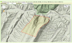
Plat Plotter converts deed ‘metes-and-bounds’ into a Plat of Survey for your use with digital maps, as well as GPS devices. According to the website, “Plat Plotter is a free, cloud-based application that uses real estate deed metes-and-bounds to plot the property boundary on a digital map. Plat Plotter converts deed ‘metes-and-bounds’ into a Plat of Survey that can be viewed in Google Maps, imported into a mapping program like Google Earth, loaded into a GPS device, sent to a printing service or shared with others.”
The link to your Plat Plotter is no longer working. 🙁 I now get this message when I click the link;
The requested URL /lib/pp_about.html was not found on this server.
I’ve used it before, but now it won’t work. It was an awesome tool to help me with old family deeds. Can it be fixed? Thanks!
I’ve updated the link found within the text – at the start of the blog and the end.That blog was done in 2014. Web addresses change, and I don’t always know it. Thanks for the heads up.