The following excerpt is from William Dollarhide’s new book, Colorado Name Lists, 1858 – 1998, with a selection of National Name Lists, 1600s – Present. Enjoy…
For genealogical research in Colorado, the following timeline of events should help any genealogist understand the area with an historical and genealogical point of view:
1541. After months of searching for the Seven Cities of Gold from the Gulf of California and the Grand Canyon, and as far north as present Colorado and Kansas, Spanish Conquistador Vasquez de Coronado finally gave up, and headed back to Mexico via the southeastern corner of present Colorado. The route Coronado followed would later be called the Santa Fe trail.
1682. French explorer René-Robert Cavelier (Sieur de la Salle erected a cross near the mouth of the Mississippi River, claiming the entire Mississippi Basin for France, and naming the region Louisiana after King Louis XIV. The mostly unexplored Louisiana claim included all of present Colorado east of the Rocky Mountains.
1720. After several Spanish expeditions noted the existence of the river, the name Rio Colorado first appeared on a Spanish map in 1720. Colorado is Spanish for “red,” the color of the river water for most of its length.
1763. The Treaty of Paris ending the French and Indian War in North America removed France from Louisiana. The area west of the Mississippi River became Spanish territory, the area east of the Mississippi River became British territory.
1765. Spanish explorer Juan Maria Rivera led an expedition into the San Juan and Sangre de Cristo Mountains in search of gold and silver.
1776. Fathers Silvestre Velez de Escalante and Francisco Atanasio Dominguez searched for a new route from New Mexico to California, and in doing so, they explored parts of present southern Colorado and Utah.
1802. Napoleon defeated Spain in battle. As spoils of war, France took ownership of Louisiana again in exchange for a couple of duchies in northern Italy.
1803 Louisiana Purchase. The United States acquired Louisiana from France, a vast area which had as a legal description, “the drainage of the Mississippi and Missouri rivers,” including all of Colorado east of the Rocky Mountains. However, Spain disagreed with that description and still claimed much of the Louisiana tract, including most of present Colorado. From their base in Santa Fe, the Spanish vowed to vigorously defend the area from any American intruders.
1804. Lewis and Clark’s Corps of Discovery left St. Louis via the Missouri River in search of a passage to the Pacific Ocean. Soon after, Spanish troops were dispatched from Santa Fe to Colorado to intercept and arrest them, but Lewis and Clark found the route north of Colorado to be more convenient. They were well into present South Dakota by the time the Spanish troops finally gave up looking for them.
1806-1807. Captain Zebulon Pike and a party of about 20 U.S. soldiers were sent to explore routes across the area of the Louisiana Purchase to the Rocky Mountains. Pike crossed the Sangre de Cristo Mountains to the Conejos River in the San Luis Valley, where he built Pike’s Stockade. He was soon placed under arrest by Spanish troops and taken to Santa Fe; but he and his men were released after a short time, and escorted back to the Arkansas River. In 1810, Pike’s published narrative of his expedition was the first English language description of the Spanish culture in North America. It was a best seller in America and Europe, and became an important source of information to a new breed of would-be trappers curious about routes to the Rocky Mountains.
1819 The Adams-Onís Treaty set the boundary between American and Spanish territory, which included the Red River as the boundary between Spanish Texas and U.S., then north to the Colorado River as the division between the Spanish Province of Nuevo Mexico and U.S. Missouri Territory, and then north along the Continental Divide to the 42nd Parallel, and finally, west to the Pacific Ocean. Before the treaty, the Spanish claims were loosely defined as everything west of the Mississippi River to the Pacific Ocean and north to at least the 42nd Parallel. As a result of the treaty, the northeastern section of present Colorado was first recognized by Spain as part of the United States (the area east of the Continental Divide and north of the Arkansas River).
1820. Major Stephen H. Long was sent by President James Monroe to explore the present Colorado region of the Louisiana Purchase. Long’s party came by way of the Platte and South Platte Rivers. Long’s Peak was named for him. Dr. Edwin James, historian of Long’s expedition, led the first recorded ascent of Pike’s Peak. James Peak, west of Denver, was named for him. Before entering present Colorado, Long and James established the main route to the Rocky Mountains via the Platte River through present Nebraska, on what would become known as the Oregon Trail.
1821. Mexico gained independence from Spain and soon after, Mexico reaffirmed the 1819 Spanish-U.S. treaty line as the Mexican-American boundary. Mexican lands were from the Louisiana line at the Sabine River, including all of present Texas, New Mexico, Arizona, and California; all of present Utah and Nevada; and present Colorado west of the Continental Divide and south of the Arkansas River. Also in 1821, the first traders from the United States came into the Mexican Province of Nuevo Mexico via southeastern Colorado on what would become known as the Mountain Route of the Santa Fe Trail.
1825. Fur-traders, trappers and Mountain Men began operations in present Colorado, including the Bent brothers, Ceran St. Vrain, Louis Vasquez, Kit Carson, Jim Baker, James Bridger, Thomas Fitzpatrick, “Uncle Dick” Wooten, and Jim Beckworth. The first trading posts they established were located in either the Arkansas River Valley or the South Platte Valley.
1832. Bent’s Fort was built by the Bents and St. Vrain near the present city of La Junta. For anyone following the Colorado River from Fort Dodge, Bent’s Fort became an important stop on the Santa Fe Trail.
1836. The new Republic of Texas asserted a claim to all land east of the Rio Grande through present New Mexico and a narrow strip of mountain territory extending into present Colorado as far north as the 42nd parallel.
1841. Texas soldiers invaded Nuevo Mexico, but were never successful in taking political control away from Mexico.
1842. Lieutenant John C. Fremont undertook the first of his five exploration trips into the Rocky Mountains and beyond.
1845. As a condition of the annexation of Texas to the United States, the Texas Claim to parts of New Mexico and Colorado was taken over by the United States. A war with Mexico resulted from this action.
1846. General Stephen W. Kearney led troops along the Santa Fe Trail through southeastern Colorado en route to the conquest of New Mexico during the Mexican War. Kearney established the provisional New Mexico Territory, which operated under U.S. protection until officially established by Congress four years later. The provisional New Mexico Territory included a sizeable portion of present Colorado south of the Arkansas River.
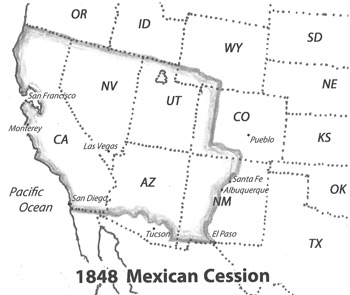
1848 Mexican Cession. At the Treaty of Guadalupe Hidalgo ending the war with Mexico, the United States annexed the area of present California, Nevada, Utah, Arizona (north of the Gila River), New Mexico, and that part of Colorado west of the Continental Divide. The U.S. paid Mexico a sum of eighteen million dollars for an area that was over half of the Republic of Mexico and comparable in size to the Louisiana Purchase.
1850. The 1850 Federal Census was taken in New Mexico Territory (Jun 1850) and Utah Territory (Apr 1851). New Mexico Territory included present Colorado south of the Arkansas River; Utah Territory included present western Colorado; and eastern Colorado was in the “Unorganized Territory” of the great plains. No population was returned from any of the Colorado areas.
1851. The first permanent white settlement in present Colorado was founded at Conejos in the San Luis Valley; irrigation was begun; and Fort Massachusetts was established. The settlement was actually in New Mexico Territory at its founding.
1853. In May, Captain John W. Gunnison led an exploring party across southern and western Colorado to survey a feasible route for a railroad through the Rocky Mountains. He was successful in mapping much of the area between the 38th and 39th parallels, but was killed in an Indian attack in October 1853. Much of Gunnison’s survey work was the completion of surveys begun by John C. Fremont’s 1847 expedition.
1854. Kansas and Nebraska Territories were established. Both extended from the Missouri River to the Continental Divide. The area of present Colorado was now within four U.S. Territories: Utah, New Mexico, Kansas, and Nebraska Territories.
1858. Green Russell’s discovery of placer gold deposits near the confluence of the South Platte River and Cherry Creek, precipitated a gold rush from the East. The “Pikes Peak or Bust” slogan began. Montana City, St. Charles, Auraria, and Denver City were founded. Pueblo was founded as Fountain City. Arapahoe County, Kansas Territory was organized.
1859. In October, Jefferson Territory was organized to govern the first mining camps and towns of present Colorado. Officers were elected, several counties were established, and in 1860, the territorial capital was established at Golden, where it would return in 1862 after Colorado City was named the first capital of Colorado Territory in 1861. Although the territorial government was never sanctioned by the U.S. Congress, Jefferson Territory operated with the consent of the local population. Also in this year, prospectors spread throughout the mountains and established camps at Boulder, Colorado City, Gold Hill, Hamilton, Tarryall, and Pueblo. Gold was found by George A. Jackson along Chicago Creek on the present site of Idaho Springs. John Gregory made his famous gold-lode strike on North Clear Creek, stimulating a rush of prospectors, who established camps of Black Hawk, Central City and Nevadaville.
1860. For the 1860 federal census, the U.S. Census Office ignored Jefferson Territory, but included an enumeration of any inhabitants of present Colorado as part of four U.S. territories: New Mexico, Nebraska, Kansas, and Utah Territories. Also in 1860, rich placer discoveries caused a stampede of miners to California Gulch at the present site of Leadville. The Colorado region continued to be administered by Jefferson Territory officials, Miners’ Courts, and People’s Courts. See the 1860 Colorado Map on page CO-10 (of the Colorado Name Lists book).
1861. After a successful invasion of the Rio Grande Valley by Confederate troops, the Confederate Territory of Arizona was declared with the capital at Mesilla. The territory included the southern half of present New Mexico and Arizona.
1861. In February, Colorado Territory was established by the U.S. Congress with the same boundaries as the present state, ending the ephemeral reign of Jefferson Territory. The first Colorado Territorial Assembly met, created 17 counties, authorized a university, and selected Colorado City as the capital. The wild west town of Colorado City was a bit too wild for even early Colorado, where saloons outnumbered churches 20 to 1. After a year, the capital was moved to Golden, about 15 miles from Denver. As part of the organic act creating Colorado Territory, a territory-wide census was required. In late 1861, the territory conducted a census as part of an election poll taken by each of the county assessors, the combined county name lists at the state archives now called the 1861 Poll Book for Colorado.
1862. Colorado troops were instrumental in defeating Confederate General Henry H. Sibley’s Army at La Glorieta Pass. The confederate control of New Mexico/Arizona ended, and the U.S. Territory of New
Mexico continued, including the parts of present Colorado south of the Arkansas River.
1863. Arizona Territory was created by the U.S. Congress. The northern boundary of Arizona Territory extended west to the California line, and included all of present Clark County, Nevada. When
Congress divided New Mexico Territory on the same meridian as Colorado Territory’s western line, the resulting map created the “four corners” of Colorado, Utah, Arizona, and New Mexico, still the only point in the U.S. where four states touch at their corners.
1866. A Colorado Territorial Census/Poll List was taken by county assessors. The lists included the names of all males over 21. Only two county lists survive.
1867. The Colorado Territorial capital was moved from Golden to Denver.
1870 Federal Census. Population of Colorado Territory at 39,864. Also in 1870, the Denver and Pacific Railroad was constructed to connect Denver with the Union Pacific at Cheyenne, Wyoming Territory.
1870-1886. The valley called North Park, which is in present-day Jackson County, Colorado, lies east of the Continental Divide, as shown on the 1860 map on page CO-10 (of the Colorado Name Lists book). The valley was not settled by whites in 1860 and 1870, but in 1870 was assumed by local officials to be part of Summit County. North Park in the 1880 and 1885 censuses was enumerated as part of Grand County, despite being claimed by Larimer. In 1886, the Colorado Supreme Court ruled that statutorily North Park had been in Larimer County since 1861.
1876. Colorado was admitted to the Union as the 38th State, one hundred years after the Declaration of Independence of the United States, hence, Colorado’s nickname became “The Centennial State.” The territorial capital of Denver became the state capital.
1880 Federal Census. Population of Colorado at 194,327.
1885. Colorado State Census was taken with federal assistance. This was the only state census taken in Colorado.
1900 Federal Census. Population of Colorado at 539,700. In 1900, Gold production reaches a peak of more than $20,000,000 annually at Cripple Creek, the second richest gold camp in the world.
2001 Broomfield County. The last county created in the U.S., in November, Broomfield County became the 64th and smallest county of Colorado.
From: Colorado Name Lists, 1858 – 1998, with a selection of National Name Lists, 1600s – Present.
I apologize for these mistakes: In the 1819 and 1832 timeline items, I referred to the Colorado River when I should have referred to the Arkansas River. Both rivers start in Colorado, but they flow in opposite directions. The Arkansas River (not the Colorado) formed the first treaty boundary between New Spain and the U.S. -bill$hide