The following article is by my friend Bill Dollarhide, taken from his book, Washington Censuses & Substitute Name Lists, 1850-2015.
 Prologue: During the early American fur-trapping days of the Oregon Country, the area that became Washington was also referred to as the Columbia District, mostly by the British fur traders in the region during the Joint Occupancy. That was the name used by the British in 1858 when they established the Crown Colony of British Columbia. When an 1853 petition was presented to Congress for the proposed Territory of Columbia, opposition to that name was expressed by a Senator from Kentucky. He argued that the Territory of Columbia was a name already in use, and proposed the name Washington instead. The Senator was quite right. The District of Columbia started out in 1791 as the Territory of Columbia, and did not lose that name until 1871, when the cities of Georgetown and Washington were merged with the Territory to form the District of Columbia. But the Senator probably did not foresee any misunderstanding about the future State of Washington vs the City of Washington. Had I been aided by Dr. Who to stand on the floor of the Senate that day in 1853, I would have counter-proposed something like American Columbia Territory, or perhaps Columbia River Territory. A native, I used to think that I was from the only state that you had to add the word “state” to clarify the correct location, e.g., “I’m from Washington State.” But, when I was in New York, I discovered that people from Upstate New York, would say, “I’m from New York State,” just to make sure you didn’t think they were from New York City. In any case, here is how the great State of Washington got started:
1775. British Capt. James Cook, fresh from the Sandwich Islands (aka Hawaii), explored and charted the Northwest Coast. He was intent on finding a “northwest passage” that would allow a ship to sail from the Pacific to Hudson Bay. En route, he looked for the mouth of a very large river in the area reported by the Spanish, but never found it. Based on the latitude-longitude noted in his ship’s log, he passed by the mouth of the Columbia River within a couple of miles.
1783. The United States Of America was recognized at the Treaty of Paris. From day one, the new government asserted a plan to inhabit the entire continent; with plans for explorations in the west, including the Pacific coast, by land or sea.
1784. The North West Fur Company was formed in Montreal. It became a rival of the Hudson’s Bay Company for dominance of the fur trade in British North America. The Hudson’s Bay Company was manned mostly by Scots-Canadians. Although both companies were British-owned, the North West Fur Company was manned mostly by French-Canadians, who fought furiously for fur trading rights, attacking Hudson’s Bay forts, burning their ships, etc., until the two companies were forced to end their differences by the British Crown.
1792. American Capt. Robert Gray entered and named the Columbia River after his ship, the same ship he used to become the first American to circumnavigate the globe. Gray and party were in the area at the same time as British Capt. George Vancouver’s party, who he met with and revealed the location of the Columbia River. Vancouver then sent Lieutenant William Broughton to confirm the existence of the Columbia River. Broughton not only confirmed it, he took his ship well into the river, landing at a point 100 miles from the mouth on the Washington side, built a temporary shelter, and named it Point Vancouver.
1803. William Clark and Meriwether Lewis led the Corps of Discovery, the first transcontinental expedition of the lands west of the Missouri River. Their trek to the Pacific was mostly via river routes, beginning at St. Louis on the Mississippi, up the Missouri River to its source in Montana, then by foot across the Mountains, picking up Idaho’s Clear River, to the Snake River of Idaho and Washington, and finally, the Columbia River all the way to its mouth at present Astoria, Oregon.
1805. Lewis and Clark explored the Washington side of the Columbia River, including Point Vancouver, the site of the future Fort Vancouver, but built their own Fort Clatsop on the Oregon side near the mouth of the Columbia River, where they spent the Winter of 1805-1806.
1806. John Jacob Astor had amassed a fortune in the trading of furs to European markets. He was America’s first multi-millionaire. Astor had established a strong business relationship with the North West Fur Company of Montreal, a British-owned company of French-Canadians in competition with the London based Hudson’s Bay Company. Immediately after the 1806 return of Meriwether Lewis and William Clark from their historic expedition to the Oregon Country, Astor began planning for a repeat of their journey. Lewis and Clark had recorded the numbers of deer, elk, bear, and beaver they encountered as part of their explorations. Astor’s motive was to gain profits from the untapped fur trading locations he had learned about from Lewis and Clark’s journals. Astor met with the leaders of the North West Fur Company and proposed a joint operation in the exploitation of the Oregon Country for its untapped riches.
1807-1810. British fur trader and mapmaker David Thompson, with the North West Fur Company, began looking for routes from the Rocky Mountains to the Pacific Ocean. He led a crew of French-Canadian fur trappers, established fur trading opportunities with any Indian Tribes he encountered, and charted detailed maps of the Columbia River. Back in Montreal, Thompson had been given instructions to join up with Astor’s American fur trappers if they should be found near the Columbia River.
1810. John Jacob Astor formed the Pacific Fur Company to expand his trading empire to the Pacific coast. In doing so, Astor had formed a loose alliance with the North West Fur Company to share the use of the region in competition against the Hudson’s Bay Company.
1811. Astor’s American fur traders built Fort Astoria near the mouth of the Columbia River as part of the Pacific Fur Company. Manned by two shiploads of men and supplies, it was the first American settlement on the Pacific Coast of North America.
– A Pacific Fur Company expedition called the Astorians traveled overland to the Oregon Country with the intent of arriving at Fort Astoria at the same time as Astor’s ships. They followed the same path as Lewis and Clark to get there, arriving a few weeks after the ships.
– Astor had convinced the North West Fur Company to participate in his expedition to the Oregon Country. David Thompson and his party of French-Canadian trappers made contact with the Astorians, and followed them down river to Fort Astoria. Thompson then set up a fur trading post for the North West Fur Company next door to Fort Astoria.
1813. After war was declared in 1812, British warships blockaded Fort Astoria. The Astorians decided it was better to get out before shots were fired, and the entire Fort Astoria operation was given to the British-owned North West Fur Company, who renamed it Fort George. The Astorians returned overland to St. Louis, and in doing so, became the first to cross South Pass, the route through the Rocky Mountains that would be followed by thousands of Oregon Trail travelers.
1814. The Treaty of Ghent ended the War of 1812, and restored all boundaries between the U.S. and Britain to the lines before the war. Invoking the Treaty of Ghent, John Jacob Astor used the provisions for returning all occupied lands by the British back to the Americans, and got the American government to allow his Pacific Fur Company to take possession of Fort Astoria again. Although the fort changed hands in ownership, the North West Fur Company continued to use it for their operations for several more years.
1818. Joint Occupation of Oregon. Before the War of 1812, both the British and Americans had extensive fur trading operations in the Oregon Country, and both laid claim to the area. In 1818, the Joint Occupation of Oregon Treaty was signed, in which the U.S. and Great Britain each agreed to a peaceful occupation of the Oregon Country. The area was defined as extending from the Continental Divide to the Pacific Ocean, and from about latitude 54° (border of Russian America), to the Siskiyou Mountains (which lie on the modern boundary between Oregon and California). Though not stated in the treaty, it was clear that the intention was to see who could settle the area first. Although the British had well-established fur trading operations in the Oregon Country, the Americans had the advantage of being closer. With newly discovered overland routes from the Mississippi River to the Columbia River, they had the ability to supply new settlers into the region. In 1827 a provision was added to the treaty that allowed either party to invoke a conclusion of ownership, by giving 12 months notice to the other.
1818. Anglo-American Convention. Included in this treaty was a provision where Britain and the U.S. agreed to the 49th parallel as the international boundary from the Lake of the Woods (now Minnesota) to the Continental Divide.
1821. The Hudson’s Bay Company and the North West Fur Company merged, retaining the name Hudson’s Bay. The company now had a monopoly on fur trading in British North America. Their presence continued in the Oregon Country as well, including their fur trading operations in present-day Montana, Idaho, Oregon, and Washington. Today, The Hudson’s Bay Company continues: “Shop the Bay!” is the slogan of Canada’s largest retailer.
1825. Fort Vancouver. The British-owned Hudson’s Bay Company established Fort Vancouver as a center for their fur trading operations in the Columbia District, the British name for the Oregon Country. Most of the employees of the Hudson’s Bay Company in the Oregon Country were French-Canadians left over from their days with the North West Fur Company. In defiance of their orders, the Hudson’s Bay Company leaders in the Oregon Country continued to cooperate with the American fur traders.
1834. The Whitman Party, including Dr. Marcus Whitman and his wife Narcissa and also Reverend Henry H. Spalding and his wife Eliza set up a mission at the junction of the Columbia and Snake Rivers. Narcissa and Eliza were the first white women to travel overland into the Oregon Country. Their travel route would become known as the Oregon Trail and used by thousands of future settlers. Soon after their arrival in present Washington, the Spaldings navigated up the Snake River to a point near present Lewiston, Idaho, where they started a mission among the Nez Perce.
1839. Fr. Pierre-Jean DeSmet arrived among the Flatheads in the Bitterroot Valley. He and his staff would set up a number of Jesuit missions in the present states of Montana, Idaho, and Washington.
1841. The Western Emigration Society, a group of about 70 settlers bound for California and the Oregon Country set off on the Oregon Trail, beginning at Independence, Missouri. This was the first organized wagon train to head for California and Oregon
NOTE: Many descendants of Oregon Pioneers claim that when the Bartleson-Bidwell wagon train reached a fork in the road near Fort Hall, Idaho, there was a sign-post ( ← California | Oregon → ) and those who could read went to Oregon.
1841. A group of Willamette Valley settlers met to organize a provisional government under the protection of the United States. However, the Americans were outnumbered by left-over French-Canadians formerly employed by the North West Fur Co/Hudson’s Bay Co, and no action was taken.
1842. John C. Fremont led an Army Topographical Corps’ Expedition to the Oregon Country. He witnesses an eruption of Mt. St. Helens. His maps of this expedition and one the following year were printed by the government and were widely used by pioneers heading west.
1843. Fort Victoria. The British-owned Hudson’s Bay Company built Fort Victoria as a fur-trading post on Vancouver Island.
1843. Provisional Territory of Oregon. A group of 50 Americans and 52 French-Canadians met again in the Willamette Valley to take a vote to determine who should govern the Oregon Country. A vote of 52-50 favored keeping Oregon as American territory (two Canadians switched their votes). The group then proceeded to form a provisional territorial government with Champoeg as its capital, established on July 5, 1843. The Provisional Territory of Oregon elected a governor, established courts, created several counties, and functioned with the consent of the local population. In 1843, the Provisional Territory of Oregon was not part of the U.S., but its successful organization was a key element in the resolution of the U.S. – British Joint Occupation in favor of the U.S.
1844-1846. In the 1844 presidential election, James K. Polk, Democrat, defeated Henry Clay, Whig, to become President of the United States. The two burning political issues of the day were the annexation of Texas and the acquisition of the Oregon Country. James K. Polk, as the “Manifest Destiny” candidate, was elected with campaign slogans of Annex Texas! and Fifty-Four Forty or Fight! In 1845, Texas was annexed to the U.S. and war with Mexico began soon after. But in 1846, Polk settled for the 49th parallel as the northern boundary of the Oregon Country. The treaty of 1846 brought the Provisional Oregon Territory into the United States.
NOTE: The presidential campaign slogans for James K. Polk were actually reverse of what really took place. His first slogan should have been, Annex Texas and Fight! and his second should have been Fifty-Four Forty or Whatever! In fact, the reason for Polk’s decision to settle the Oregon Country question with the 49th parallel was simply that he did not want to go to war with Mexico and Britain at the same time.
1846-1849. After the Oregon Treaty in 1846, the area below the 49th Parallel became American territory, and the British shifted their fur-trading operations from Fort Vancouver on the Columbia River to Fort Victoria. which became the capital of the Crown Colony of Vancouver Island in 1849.
1848. James K. Polk signed a bill that created Oregon Territory. It encompassed the area between the 42nd and 49th parallels, from the Pacific Ocean to the Continental Divide. The first capital was Oregon City. Virtually all of the political structures established by the Provisional Oregon Government were adopted by the official Territory of Oregon, including the counties in place at that time, most of the laws, and most of the court system was retained. Polk became the President who brought more territory (12 modern States) into the United States than any other. During his administration, the Oregon Country, Texas, and the Mexican Annexation were added to the U.S., and for the first time, America became a nation “from sea to shining sea.”
1850. June. Federal Census was taken in Oregon Territory, which included the area of present Oregon, Washington, and Idaho; and Montana and Wyoming areas west of the Continental Divide. The population was revealed as 12,093 people. The population was limited in the present Washington area to a few residents of Clarke and Lewis counties, all south of Puget Sound and west of the Cascade Mountains. No population was recorded in the present Idaho, Montana, or Wyoming areas.
1850. Sept. Congress passed the Donation Land Claim Act. The forerunner of the 1862 Homestead Act, the Donation Land Claim Act was aimed entirely as an incentive to get settlers to move to Oregon Territory. From 1850 to 1855, land records for the areas that became Oregon and Washington provide detailed genealogical sources, revealing names, birthdates, birthplaces, marriage information, and citizenship. Note: a searchable database is available at the WA Digital Archives.
1853. Washington Territory was created. It encompassed the present area of Washington, but extended east to the Rocky Mountains, incorporating areas that today are in northern Idaho and western Montana. As a result, the original Oregon Territory was split in half. Oregon Territory now had lands on the same line as its present northern border stretching to the Continental Divide, and included the southern half of present Idaho, and a portion of present western Montana and Wyoming.
1858. British Columbia. After the Fraser Canyon Gold Rush, the Vancouver Island Colony was merged into the Crown Colony of British Columbia, established in 1858 with Vancouver as the capital.
1859. Oregon joined the Union as the 33rd state, a Free State with the same boundaries as present. The population of the new state was about 45,000 people. The eastern remnants of Oregon Territory, 1853-1859, were added to Washington Territory.
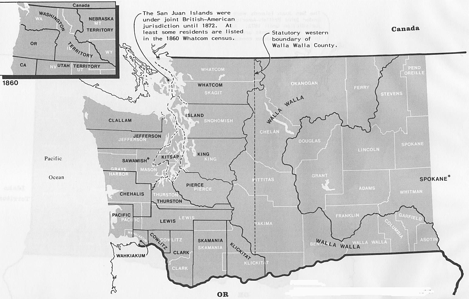
1860. June. Federal Census, Washington Territory. The population of Washington Territory was at 11,594 people. The map above shows in black, the 19 counties of Washington Territory at the time of the 1860 Federal Census. The current 39 counties of Washington are shown in white. * Notes: Washington Territory was created in 1853. When the state of Oregon was established in 1859, the eastern parts of old Oregon Territory were added to Washington Territory. In 1860, Old Spokane County encompassed an area from the Columbia River to the present-day Idaho panhandle, and into northwestern Montana. The first Spokane County was renamed Stevens in 1864. The current Spokane County was created in 1879. Sawamish was renamed Mason in 1864. Map Source: Page 361, Map Guide to the U.S. Federal Censuses, 1790-1920, by William Thorndale and William Dollarhide.
1863. Idaho Territory was created, reducing Washington Territory to its present size and shape.
1883. The Northern Pacific Railroad was completed to Tacoma, linking Washington to the east.
1889. Nov 11th. Washington became the 42nd state in the Union. Olympia was the state capital.
About Washington’s Censuses:
WA Territorial Censuses. Washington Territory, created from Oregon Territory in 1853, had territory-wide censuses conducted every few years until statehood in 1889. There is excellent coverage for virtually all Washington Territory counties, some borrowed from Oregon Territory from as early as 1847-1851; and WT counties from 1856-1889.
– To cover the earliest possible censuses for the area of present Washington, one needs to look at Oregon Territory first. For example, the 1850 federal census of Oregon Territory included Lewis County (west of the Cascade Mountains), and Clarke County (east of the mountains), covering all of the populated areas of what became Washington Territory.
– Between the time of the 1850 federal census and the formation of Washington Territory in 1853, the Oregon Territory legislature created six more counties in the area of present Washington. As a result, the area that became Washington Territory in 1853 began with eight counties inherited from Oregon Territory, all of which need to be reviewed for possible censuses. The eight counties and their Oregon creation dates and parent counties were as follows:
– Clarke County, 1844, as the original “Vancouver District” by the Provisional Oregon Government.The name Clarke came in 1849, the ‘e’ was dropped in the 1920s.
– Lewis County, 1845, an original county created by the Provisional Oregon Government.
– Pacific County, 1851, from Lewis.
– Jefferson County, 1852, from Lewis.
– Thurston County, 1852, from Lewis.
– King County, 1852, from Thurston.
– Pierce County, 1852, from Lewis.
– Island County, 1853, from Lewis.
At its first legislative session in 1854, Washington Territory recognized the eight Oregon-born counties; then created eight more on its own:
– Clallam County, from Jefferson.
– Cowlitz County, from Lewis.
– Chehalis County, from Thurston. (Chehalis was renamed Grays Harbor County in 1915).
– Sawamish County, from Thurston. (Sawamish was renamed Mason in 1864).
– Skamania County, from Clarke.
– Wahkiakum County, from Lewis.
– Walla Walla County, from Clarke.
– Whatcom County, from Island.
The above sixteen counties represent the “original” counties of Washington Territory. The federal organic act creating Washington Territory in 1853 dictated that a census be taken “previous to the first election.” This was a territorial census conducted in 1854 for the purpose of apportionment of the first elected territorial legislature. (Of the sixteen counties, only the 1854 Pierce County census name list appears to have survived).
– After the first territorial census of 1854, several more territorial censuses were authorized for the purpose of apportionment of the territorial legislature. Surviving census manuscripts exist for at least one county for the years 1856, 1857, 1858, 1859, 1861, 1871, 1879, 1881, 1883, 1885, 1887, and the last one in 1889, the same year in which Washington became a state. Those censuses taken in the 1880s are fairly complete for all of the counties in place during the territorial era.
WA State Censuses. After joining the Union as a state in 1889, Washington took at least two state-sponsored censuses, perhaps more – since censuses exist for a few counties dated 1891, 1892; and a few more dated 1894; and one county dated 1898.
WA Federal Censuses. As part of Oregon Territory, the first federal census for Washington areas was complete for all counties in 1850; Washington Territory in 1860, 1870, and 1880; and Washington State, 1900 through 1940. The 1890 was lost, like all states.
Further Reading:
Washington Censuses & Substitute Name Lists, 1850-2015 (Printed Book), Softbound, 83 pages, Item FR0303.
Washington Censuses & Substitute Name Lists, 1850-2015 (PDF eBook), 83 pages, Item FR0304.
Online Washington Censuses & Substitutes: A Genealogists’ Insta-Guide ™ (Laminated), 4 pages, 3-hole punched, Item FR0373.
Online Washington Censuses & Substitutes: A Genealogists’ Insta-Guide ™ 4 pages, Item FR0374.