The following article is by my friend Bill Dollarhide, taken from his book, Tennessee Censuses & Substitute Name Lists, 1769-2008
 Prologue: This historical timeline starts with the beginnings of the Carolinas, as the progenitors of the region known as Tennessee.
1623. Carolana. The first charter for an English colony in the area of the Carolinas was granted to Sir Robert Heath by King James I, but due to the political climate in England (an impending Civil War), the Carolana charter would never be used. The name Carolana came from “Carolus,” Latin for Charles.
1663. Carolina. Charles II granted eight noblemen a charter to Carolina, “sea to sea,” from Latitude 31° (present FL/GA line) to Latitude 35° (present GA/TN line). This was a repayment for their loyalty and support during the English Civil War. The eight became known as the Lords Proprietors. In 1665, the charter was extended north to the present NC/VA line to include the Albemarle Sound settlements.
1712. North Carolina and South Carolina. The territory of the Province of Carolina since 1665 ran from about Latitude 31° to the present NC/VA line (36°30’), including the area of present Georgia. In 1712, the Lords Proprietors divided Carolina into North Carolina and South Carolina (proprietary provinces) on nearly the same division line as today, but the line was not surveyed for several more years. Each province had its own colonial governor, under the authority of the eight Lords Proprietors. The area of North Carolina extended from the Atlantic Ocean to the Mississippi River, and included all of present Tennessee.
1707. England and Scotland merged to become the United Kingdom of Great Britain. The English Colonies now became the British Colonies.
1717. The arrival of the first Scots-Irish immigrants to the British Colonies was via Boston, New York City, Philadelphia, Alexandria, New Bern, and Charles Towne. The so-called Scots-Irish (or Ulster Scots) were former border clan people who had lived near the Scottish-English border for centuries. A good number of them had moved into areas of Northern Ireland in the early 1600s, and a mass migration to most of the British colonies of America began in about 1717. By 1775, the Scots-Irish outnumbered (by three times) the total of the other British groups in colonial America (Puritans, Cavaliers, or Quakers). The Scots-Irish were the earliest settlers of western Virginia and North Carolina (aka Kentucky and Tennessee); as well as Georgia, Alabama, Mississippi, and Texas.
1729-1777. In 1729, the Province of North Carolina became a separate Royal British Colony after seven of the eight Lords Proprietors sold their interest back to the Crown. A large portion of original proprietor land was retained by Lord John Carteret. In 1744, Carteret inherited the title of Earl of Granville. Soon after, the former proprietor began selling land in his privately held Granville District, the northern half of present North Carolina and Tennessee. The first few years of land sales were well documented, providing good evidence of the earliest inhabitants of central and western North Carolina into the 1760s. Later records were incomplete due to cross-claim disputes. The Granville District operation dissolved in 1777. Surviving records of the land sales in the Granville District, including the first land sales in present Tennessee, are located today at the NC State Archives in Raleigh.
1746. Pioneer’s Road. The first wagon road through the Blue Ridge Mountains of Virginia was constructed in 1746, allowing wagon traffic from Alexandria to Winchester, Virginia. The first travelers on the roadway were almost exclusively Scots-Irish immigrants, who had changed their travel plans to arrive in Alexandria instead of Philadelphia. The trace of the old Pioneer’s Road is now called US Hwy 50. At Winchester, the Great Valley Road / Shenandoah Valley of Western Virginia gave travelers a way to the southwestern end of Virginia – eventually the primary route used by the first settlers to migrate into East Tennessee.
1763. The Treaty of Paris ended the French and Indian War (in Europe and Canada: the Seven Years War). France ceded all of its North American claims east of the Mississippi to Britain. Soon after, King George III declared the “Proclamation Line of 1763,” as a way of rewarding the Indians who had helped Britain against the French. The proclamation line established an Indian Reserve that stretched from the Appalachian Mountain Range to the Mississippi River.
1768. Treaty of Fort Stanwix. A new “Line of Property” was drawn, separating British Territory from Indian Territory. From Fort Stanwix (present Rome, NY), the division line ran to Fort Pitt (now Pittsburgh) and down the Ohio River to the Tennessee River. The Fort Stanwix treaty line effectively ceded all of present West Virginia and Kentucky to the British Colony of Virginia.
1770-1775. East Tennessee. The first migrations of people into present East Tennessee began between 1770 and 1775 with the Watauga settlements, evolving into the North Carolina communities of Elizabethton and Jonesborough. Most came by way of the Great Valley Road of Virginia, leading to the Clinch River Valley and into present Tennessee.
1775-1783. The Transylvania Land Company. In 1775, the Cherokee Indians sold North Carolina Judge Richard Henderson huge quantities of land between the Ohio, Kentucky, and Cumberland rivers for the Transylvania Land Company. Under Henderson’s employ, Daniel Boone blazed and cleared the “Wilderness Trail” and established Fort Boonesborough. By 1783, some 60,000 settlers had used the Wilderness Trail to move into Kentucky. Plans for the Transylvania Company’s proposed colony in present Tennessee were never fulfilled – the company was not recognized by either Virginia or North Carolina and was dissolved in 1783.
1779. French Lick Settlements. The first Cumberland River settlements of present Middle Tennessee were in the French Lick area, beginning with Fort Nashborough, the forerunner of the city of Nashville. Both the Tennessee and Cumberland Rivers provided access to the Middle Tennessee settlements.
1784. State of Franklin. Feeling abandoned by their government in New Bern, North Carolina, settlers living in present Northeastern Tennessee declared their area an independent state and named it Franklin. Jonesborough was their capital. Franklin functioned as a state for four years with the consent of the local population. But in 1788, Franklin’s petition to Congress for official recognition was denied. The area was reclaimed by North Carolina where it remained until the Southwest Territory was formed in 1790.
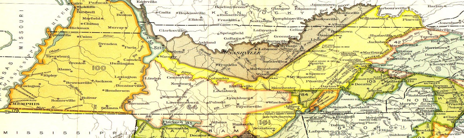
1785-1818. Early Indian Land Cessions in Tennessee. After the demise of the Transylvania Company, the earliest recognized Indian Land Cession in present Tennessee was between the U.S. Government and the Cherokees in 1785 (Cession No. 3 on the map), including the present towns of Nashville, Carthage, and Byrdstown, Tennessee; and Albany, Burkesville, and Monticello, Kentucky. An 1818 Treaty with the Chickasaw (Cession No. 100 on the map) included the western parts of Tennessee and Kentucky lying between the Tennessee and Mississippi Rivers. The Tennessee portion of Cession No. 100 is called West Tennessee. The Kentucky portion of Cession No. 100, is referred to as The Jackson Purchase. Cession No. 100 was purchased from the Chickasaw by the U.S. Federal Government, but title to the land went to Kentucky and Tennessee, both state land states with their own General Land Office for the purpose of surveying and selling land to the public.
1787. Nashville Road. To attract settlers into its western areas, North Carolina financed the construction of a wagon road from Knoxville west to the Cumberland settlements around Fort Nashborough. The road was first called Avery’s Trace after the scout and woodsman who was hired to blaze the trail. It soon became known as the Nashville Road. As a direct result of the new wagon road, the population of the Middle Tennessee region surged.
1790. May. Southwest Territory. North Carolina ceded the area of present Tennessee to the federal government. Soon after, the Territory South of the River Ohio (more commonly, the Southwest Territory) was created by Congress.
1790. Aug. Federal Census. The Northwest and Southwest Territories were specifically left out of the first census of 1790. But, Secretary of State Thomas Jefferson, perhaps as an afterthought, asked Governor William Blount if he wouldn’t mind taking a census in the Southwest Territory. Blount responded with a tally of the inhabitants (but no names) in each of the original seven counties, taken in July 1791. For that time period, tax lists and other names lists from the counties of Greene, Hawkins, Knox, and Washington cover the first areas of settlement in East Tennessee; while lists from the Middle Tennessee counties of Tennessee County (later replaced with Montgomery and Robertson), Davidson, and Sumner counties cover the rest of the population.
1791. July. Governor Blount’s tally of the residents of the Southwest Territory showed a population of 35,691 people.
1796. June 1. Tennessee became the 16th state in the Union, with Knoxville as the first state capital.
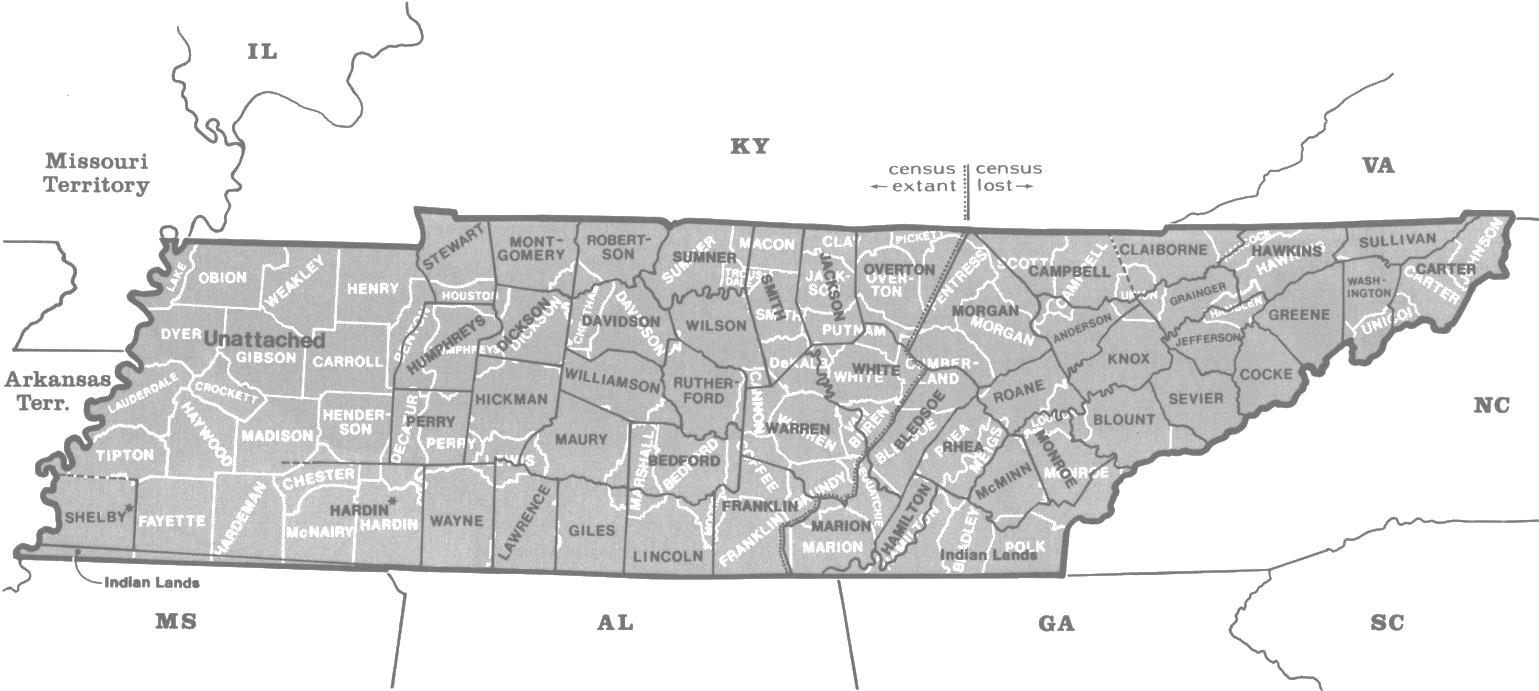
1820. Aug. Federal Census. The above map shows the current 95 counties of Tennessee in white. The 48 counties of Tennessee at the time of the 1820 Federal Census are shown in black. Notes: 1) The large Unattached area of West Tennessee on this map should be compared to the Indian Cessions map (1885 above) where the Chickasaw Cession of 1818 is shown (Cession No. 100). 2) In 1819, Hardin County was created to run to the Mississippi, but eleven days later Shelby was created, its northern boundary defined by an unsure legislature about where the line should lie. The state law vaguely stated that the northern line of Shelby should extend “…as far north as necessary to include a constitutional county.” 3) The 22 counties indicated as “census lost” on this map were all included in the 1st federal court district (Courthouse: Knoxville). The 26 counties indicated as “census extant” were all included in the 2nd federal court district (Courthouse: Nashville). In response to the 1830 law asking all original census manuscripts, 1790-1820, to be transmitted to Washington, DC, the Clerk of the Court for the 1st District (Knoxville) could not comply, i.e., the census manuscripts were lost in Tennessee, not Washington, DC, as it has been incorrectly reported by some). Map Source: Page 317, Map Guide to the U.S. Federal Censuses, 1790-1920.
Further Reading:
Tennessee Censuses & Substitute Name Lists, 1769-2008 (Printed Book), softbound, 81 pages, Item FR0293.
Tennessee Censuses & Substitute Name Lists, 1769-2008 (PDF eBook), 81 pages, Item FR0294.
Online Tennessee Censuses & Substitutes: A Genealogists’ Insta-Guide TM (laminated), 4 pages, 3-hole punched, Item FR0363.
Online Tennessee Censuses & Substitutes: A Genealogists’ Insta-Guide TM (PDF eBook), 4 pages, Item FR0364.