The following article is by my friend Bill Dollarhide, taken from his book Ohio Censuses & Substitute Name Lists, 1787-2013.
 Prologue: The timeline begins with Ohio’s first European visitors, its jurisdictions in French, British, and American claims; with the names, places, and events important to the growth of Ohio.
1614-1615. Ohio Country. Samuel de Champlain, governor of New France and the founder of Québec, was the first of the French explorers to visit the Ohio country via Lake Erie. He is believed to have entered the Maumee River in 1614 or 1615.
1668. Great Lakes region. French Jesuit missionaries Jacques Marquette and Claude Dablon established the first mission at Sault Sainte Marie.
1670. Illinois Country / Great Lakes region. René-Robert Cavelier (Sieur La Salle) explored and claimed the Illinois Country for France. That was the first name for the entire Great Lakes region, including present Ohio.
1717. French Louisiana. The Illinois Country was officially added to the French Louisiana jurisdiction within New France. At that time la Louisiane Française extended from the Wabash River, down the Ohio and Mississippi Rivers to include several ports on the Gulf of Mexico. Any trading posts or forts north of the Highlands (Terra Haute) were considered part of French Québec.
1721. Fort Philippe, later called Fort Miami, was built by the French on the St. Mary’s River, near present Fort Wayne, IN where the St. Mary’s, St. Joseph’s and Maumee Rivers meet.
1754-1763. French and Indian War. The Ohio Company of Virginia asserted its British claim to the Ohio Country and began sending fur trading parties to the area. The British map of Virginia in 1754 was based on the claim of Sir Walter Raleigh (1584), who had claimed and named Virginia as everything between present Florida and Chesapeake Bay, “sea to sea,” but Raleigh’s northern line from the Chesapeake extended on a 45° angle to the North Pole. thus Virginia included the entire Great Lakes region. The French map of the 1754 Illinois Country was based on the explorations of Samuel de Champlain (1614) and René-Robert Cavelier (1670). The British encroachment into the French Illinois Country and the French encroachment into British Virginia led to a war between Britain and France. In America, the war was called the French and Indian War, but the conflict expanded into a global war with virtually every country of Europe involved. In Europe, the war was called the Seven Years War. The first French Fort in the Illinois Country/Virginia area was at the Forks of the Ohio, Fort Duquesne (now Pittsburgh) which became the focus of British military forays into the western wilderness of colonial America for the first time. As a result of those forays, two wagon roads emerged (Braddock’s Road and Forbes’ Road) that after the war provided overland migration routes to the Ohio River.
1763. Treaty of Paris. This was the end of the French and Indian War / Seven Years War. At the 1763 Treaty, the big loser was France, who was forced to surrender all their remaining claims in North America. Spain acquired the former French areas west of the Mississippi, renamed Spanish Louisiana. Great Britain gained all of Québec, and also gained control of the rest of areas east of the Mississippi River, including Florida (which they immediately divided into West Florida and East Florida. They named their entire area British North America. The British continued the most important activity in the acquired areas: fur trapping and trading. The Hudson’s Bay Company and the North West Fur Company, both British owned companies, were entrenched in the Great Lakes region, and the British Army was there for their protection.

1763. British North America / Proclamation Line. Soon after the Treaty of Paris, King George III issued the Proclamation Line of 1763, as a way of rewarding the Indians who had helped Britain against the French. The proclamation established an Indian Reserve that stretched from the Appalachian Mountain Range to the Mississippi River – preventing the British colonists from migrating into their undeveloped western regions. The Proclamation was to become one of the “Intolerable Acts” that led to an American rebellion.
1768. Treaty of Fort Stanwix. An adjustment to the Proclamation Line of 1763 took place in New York. The British government, led by Sir William Johnson, met with representatives of the Six Nations (the Iroquois) at Fort Stanwix (now Rome, NY). A new “Line of Property” was drawn, separating British Territory from Indian Territory. From Fort Stanwix, the division line ran to Fort Pitt (now Pittsburgh) on about the same line as the 1763 Proclamation Line; but at the Forks of the Ohio, the line followed the Ohio River to the Tennessee River, then into the present Kentucky and Tennessee regions. The Fort Stanwix treaty line effectively ceded present West Virginia and Kentucky to Virginia, and a sizable area of western North Carolina to the Tennessee River was opened for white settlement for the first time.
1774. Québec Act. In response to increased American colonial rebellions, the British sought to solidify loyalty from their former French communities in British Canada. The British Parliament passed the Québec Act, which restored the name Province of Québec, allowed the French Canadians to retain French laws and customs, and permitted the Catholic Church to maintain all of its rights. The early French claims to present-day Ohio, Michigan, Indiana, Illinois and Wisconsin, were by the act included in the Province of Québec, under British rule.
1776-1783. Revolutionary War in the Great Lakes Area. British-held interests in the Great Lakes region suffered major defeats, losing the former French communities of Vincennes and Kaskaskia. Both victories were led by American General George Rogers Clark, who was later called the Conqueror of the Old Northwest. But the British maintained other communities without a fight, such as Fort Detroit, Prairie du Chien, and Fort Miami (now Fort Wayne). The left-over British presence in the Great Lakes region was related to the fur trade, a lucrative source of revenue they were reluctant to leave.
1783. The Treaty of Paris recognized the United States of America as an independent nation and defined its borders from the Atlantic Ocean to the Mississippi River. Although the settlements in the Great Lakes region (formerly part of the Province of Québec) were to be included within the United States, British military forces continued to maintain control of a string of trading posts and forts in the Great Lakes area for several years after the Revolution.
1784. Ohio Country. Connecticut, Virginia and Massachusetts relinquished their claim to lands in the Ohio Country. Title transferred to the “public domain” of the United States Government. Connecticut retained ownership of the Western Reserve on Lake Erie, then sold the tract to the Connecticut Land Company in 1795. The bounds of the Western Reserve can be viewed on the 1800 map below.
1787. Jul 13. Northwest Territory. The Ordinance of 1787 established the Territory Northwest of the River Ohio, and defined the procedure for a territory to obtain statehood. Present states carved out of the original area of the Northwest Territory included Ohio, Indiana, Illinois, Michigan, Wisconsin, and that part of Minnesota east of the Mississippi River.
1788. Flatboats. The initial family transportation on the Ohio River (usually beginning at Pittsburgh, later Wheeling) was by a flatboat designed for a one-way trip. The large, steerable rafts were constructed of lumber and nails that could be disassembled by migrating families when they arrived at their new home sites along the Ohio River and tributaries. Flatboats remained the primary method of entering the Northwest Territory until the first inland wagon road (Zane’s Trace) was built in 1796.
1788. First Ohio Settlements. Marietta was present Ohio’s first permanent settlement. It was founded in 1788 by General Rufus Putnam and named in honor of Marie Antoinette. Putnam’s Ohio Company of Associates purchased a large tract of land above the Ohio River and sold parcels to the first settlers of Ohio. The Ohio Company purchase was followed soon after by the Symmes Purchase, located “Between the Miami Rivers,” with a land office near present Cincinnati, Ohio. Most of the first settlers arriving at Marietta or Cincinnati came by Ohio River flatboats via Brownsville, Pittsburgh, or Wheeling.
1790. The Northwest Territory Population was specifically left out of the 1790 Federal Census. Since the purpose of the census was to apportion the U.S. House of Representatives, Congress decided that a count of people (with no representation in Congress) in the territories was not necessary. Estimates of the 1790 white population was about 4,200 people, which included those in Fort Detroit and Fort Miami, two enclaves still under control of the British Army. There were about 2,000 left-over French-Canadian fur-trappers and traders, mostly around Vincennes and Kaskaskia. The Ohio region had an estimated 1,000 settlers in the Ohio Company settlements near Marietta, and another 1,200 souls in the Symmes Settlements near Cincinnati. Except for these settlements, the entire Northwest Territory was still mostly under control of the Indians. In 1786 they had joined together to form a Western Confederation of American Indians to defend their territory from the white invaders.
1791. Northwest Indian War. Territorial Governor Arthur St. Clair, a former Revolutionary War general, was the leader of the local militia force. In 1791, he suffered a terrible defeat against the Western Confederation of American Indians, with over 1,000 militia deaths. Soon after this battle, the confederacy received the official support of the British government of Upper Canada, who hoped to continue their fur-trading businesses with the Indians of the Ohio Country.
1792. Legion of the United States. President George Washington had long believed that the United States did not need a large Regular Army during peacetime, and that local militia forces could handle any military needs. General St. Clair’s disastrous defeat in the “Battle of a Thousand Slain” changed his mind. In 1792, Washington reactivated Major General Anthony Wayne, his favorite Revolutionary War general, to counter the Indian attacks in the Northwest Territory. General Wayne was put in charge of an all new Legion of the United States, the first post-Revolutionary War regular army force.
1794. Battle of Fallen Timbers. Led by General “Mad” Anthony Wayne, the Legion of the United States mounted a ferocious assault against the Indian forces concentrated on the Maumee River near present Toledo, Ohio. The American forces won a decisive victory which led to the end of the Northwest Indian War.
1795. The Treaty of Greenville was the official end to the Northwest Indian War. A “Greenville Line” across present Ohio and Indiana defined the extent of areas opened to settlement by whites. The Greenville Line is easily seen on the 1800 map below, where the northwest area of “Indian Lands” is indicated above the Greenville Line.
1796. Jay Treaty. Thirteen years after the Treaty of Paris in which the boundaries of the United States had been defined to include the entire Great Lakes region, Great Britain finally relinquished control of a series of military forts from Lake Champlain to the Mississippi River, including the Northwest Territory military bases at Fort Detroit and Fort Mackinac. The defeat of the Confederacy of Indians supported by the British Government and the subsequent Treaty of Greenville in the Northwest Territory were the events that allowed the Jay Treaty to take place. The British-owned fur-trading companies were allowed to continue their operations in the Great Lakes region, and their employees residing in the U.S. were given the option of becoming U.S. citizens.
1796. Zane’s Trace. Col. Ebenezer Zane, founder of Wheeling, Virginia (now West Virginia), operated a ferry across the Ohio River. In 1796, Zane made a deal with the U.S. Government to construct a wagon road, beginning at his ferry landing across from Wheeling, and heading west into the public land areas of what was to become the state of Ohio. Zane said he would build the road from Wheeling to Limestone (now Maysville, KY), in exchange for land grants where the new road intersected the Muskingum, Hocking , and Scioto rivers. Zane’s Trace was the first wagon road into the Ohio Country. See the earlier Blog article, Getting Stumped on Zane’s Trace for more details on this wagon road.
1800. July. Indiana Territory was established from the Northwest Territory with William Henry Harrison as the first Governor and Vincennes the capital. The area included all of present Indiana, Illinois, Wisconsin, and the western half of Michigan. The Northwest Territory was reduced to the present-day area of Ohio and the eastern half of Michigan. See the inset on the 1800 OH/Northwest Territory map below.
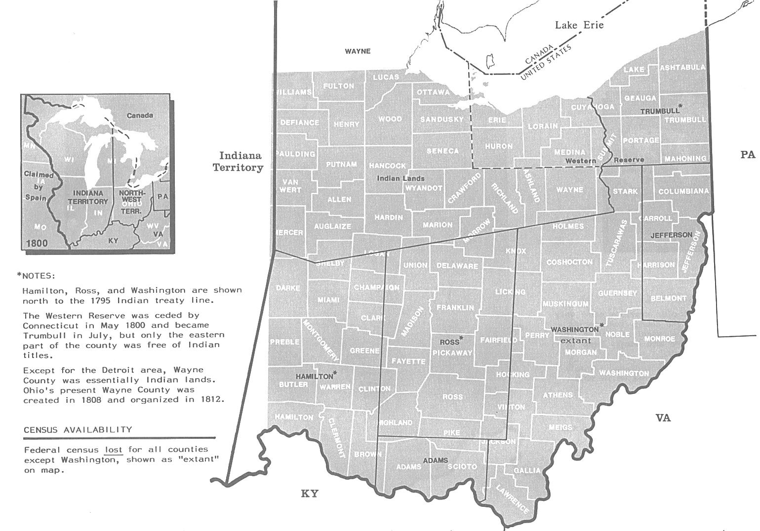
1800. Aug. Map of Ohio as part of the Northwest Territory. Prior to the 1800 federal census, Congress had decided that a census in a territory might be useful for determining whether the population was sufficient for the territory to petition for statehood. Beginning in 1800, all U.S. territories were included in the federal censuses. The above map shows in black the five counties of the Ohio area at the time of the 1800 Federal Census. The current 88 counties of Ohio are shown in white. The population of the Northwest Territory in August 1800 was 42,159 people. The original census schedules for the 1800 Northwest Territory census were lost for all counties. However, the 1800 Washington County census name lists were copied into the New Ohio Company records. Those manuscripts have survived and are located today at the Campus Museum, Marietta College, Marietta, Ohio. Map Source: Page 268, Map Guide to the U.S. Federal Censuses, 1790-1920..
1803. Mar 1. Ohio was admitted to the Union as the 17th state, with boundaries nearly the same as today. Chillicothe was the first state capital. The portion of Michigan included in the Northwest Territory 1800-1803 became part of Indiana Territory. Upon Ohio’s statehood, the name Northwest Territory was dropped.
1805. Michigan Territory was created, taken from the Indiana Territory. The original area was between Lake Michigan and Lake Huron, as today, but included only the eastern tip of the Upper Peninsula, the rest was under control of Indiana Territory. The territorial capital was at Detroit.
1810. Ohio. The state capital was moved from Chillicothe to Zanesville.
1812-1813. Ohio in the War of 1812. Fort Meigs was constructed to protect Ohio from an invasion of British troops during the War of 1812. The fort was the largest walled fortification in North America. In 1813, Fort Meigs successfully defended the Maumee River gateway to Ohio and Indiana from two major invasions of the British Army and their allied Indians.
1812-1815. Steamboats. First introduced in 1812, steamboats would soon become the main mode of transportation on the Ohio and Mississippi Rivers. The classic flat-bottomed steamboat design began in 1815. Before that the boats had too much draft for the Ohio River low water seasons.
1814. Treaty of Ghent. The War of 1812 ended. The British had successfully defended their territory in present Canada, but retreated from captured areas in the Great Lakes region. The end of the war allowed for the American settlement of the Old Northwest to resume in earnest.
1816. Ohio. The state capital was moved from Zanesville to Columbus.
1825. Erie Canal opened. This New York route from the Hudson River to Lake Erie provided direct access to the Ohio Country. It was now possible for a sailing ship to dock at New York Harbor, where passengers could connect to a steamboat going up the Hudson River to Albany and the start of the Erie Canal. Western New York and the State of Ohio were impacted the most, with many settlements attributed to the early Erie Canal travelers. For example, Ohio’s 1820 population of 581,434 people increased to 937,903 in 1830, an increase heavily attributed to the first five years of Erie Canal traffic, 1825-1830. The opening of the Erie Canal gave rise to a new shipbuilding industry near Buffalo. Soon, a fleet of steamboats began transporting Americans, Germans, Swedes, Norwegians, and other European immigrants to points all over the Great Lakes region.
1835. Toledo War. Michigan Territory’s drive for statehood created heated arguments in Congress over the Michigan-Ohio boundary. Michigan was not admitted to the Union because Ohio would not surrender their claim to the Toledo strip. As an adjoining state, Ohio asserted its veto power over the first attempt for statehood for Michigan Territory.
1837. Jan 26. Michigan was admitted to the Union as the 26th state, after the Toledo Strip was finally surrendered in exchange for the remainder of the Upper Peninsula. Ohio gained the Toledo strip from Michigan, and Michigan gained the Upper Peninsula, extended to its present border with Wisconsin. At first, it seemed that Ohio had won the Toledo War, because Ohio was really interesting in using the Toledo Strip as the start of a new canal. But later, Michigan claimed victory, due to the huge increase in natural resources gained from Upper Peninsula.
1845. The Miami and Erie Canal was opened for business by the state of Ohio. Running from Toledo to Cincinnati, it was the longest canal in America and an enterprise that probably would not have happened without the help of a major land donation by Michigan. For the first few years of operation, the M & E Canal was a financial success. In the 1850s, railroads began operating in Ohio, and the preferred method of transportation shifted from wagon roads and water canals to railroads.
About Ohio’s Censuses & Substitutes
There has never been a state-sponsored census taken in Ohio, at least not one using the name “census.” An “enumeration” was authorized in the State Constitution of 1802, which provided for a listing of white males over the age of 21 to be taken every four years. They became known as Quadrennial Enumerations. In addition, there were a series of tax lists from each of the Ohio counties that became known as Duplicate Tax Lists. Together, these name lists have become the primary census substitutes for all of Ohio:
Ohio Quadrennial Enumerations. The first of these enumerations was taken in 1803, and continued every four years until they officially ended in 1911. Tax assessors from each county were in charge of the Quadrennial Enumerations, and they were often taken simultaneously with lists of property owners subject to taxes. But the Quadrennial Enumeration lists were separate from tax assessment lists – they were compiled specifically for determining the number of males of voting age and reapportioning the state legislature every four years. Of the more than 1,800 county-wide Quadrennial Enumerations taken between 1803 and 1911, less than 100 county name lists have survived.
Ohio Duplicate Tax Lists. During the first half of the 19th century, numerous tax lists were taken at the county level in Ohio. The original lists were gathered and maintained by county tax assessors, with a duplicate copy sent to the state auditor’s office. Some of the original county tax lists have survived, but most of the surviving name lists today are the state auditor’s duplicates. It is the Duplicate Tax Lists that are more common census substitutes with microfilm copies available for virtually all counties of Ohio.
Ohio Federal Censuses. The earliest census taken in the Northwest Territory was for 1800, and the first federal census taken in the state of Ohio was for 1810. Both censuses were lost for most areas. The exception was for Washington County, where Rufus Putnam’s Ohio Company of Associates kept good records beginning in 1788, and saved copies of the earliest censuses. Putnam’s papers are located today at the Campus Museum of Marietta College, Marietta, Ohio. The federal censuses, 1820 through 1940 are complete for all counties of Ohio, with the exception of the 1890, lost in a fire in Washington, DC in 1921 (like all states).
Further Reading:
Ohio Censuses & Substitute Name Lists, 1787-2013 (Printed Book), Softbound, 85 pages, Item FR0279.
Ohio Censuses & Substitute Name Lists, 1787-2013 (PDF eBook), 85 pages, Item FR0280.
Online Ohio Censuses & Substitutes: A Genealogists’ Insta-Guide™, Laminated, 3-hole punched, 4 pages, Item FR0349.
Online Ohio Censuses & Substitutes: A Genealogists’ Insta-Guide™ (PDF version) 4 pages, Item FR0350.