The following article is by my friend Bill Dollarhide, taken from his book, North Carolina Censuses & Substitute Name Lists, 1660-2011 .
 Prologue: This historical timeline begins with the first English discoveries along the Atlantic Coast of North American and the “Lost Colony” of Roanoke; followed by the era of the English Civil War, which was the root origin behind the founding of the Province of Carolina. The subsequent events, people, and places important to the growth of North Carolina have to be viewed along with the historical events taking place in England:
1498. Italian sea captain Giovanni Caboto was commissioned by the English King Henry VII to explore America. He landed in 1497 on the island of Newfoundland. There is recently discovered evidence that on his second trip in 1498, he visited the coasts of present New Jersey, Delaware, Maryland, Virginia, North Carolina, South Carolina, and Georgia. He made the initial claims to the English North America region in the name of the English king. In honor of the event, the king changed his name to John Cabot.
1558. Elizabeth I became Queen of England. The early explorations of English North America took place during her 45-year reign, the Elizabethan Era, or “Golden Age.” When Elizabeth I was crowned, England was nearly bankrupt, but during her reign, the English Empire expanded and thrived, and English culture flourished in Literature, Theater, Music, and Architecture.
1584. Virginia. Sir Walter Raleigh claimed and named Virginia for the “Virgin Queen,” Elizabeth I, an area from present Chesapeake Bay to Florida, and everything “sea to sea” below a northwestern line to the North Pole.
1584-1590. Roanoke Colony. In 1584, Queen Elizabeth I granted to Sir Walter Raleigh a charter for the colonization of the entire area of English North America, i.e., Virginia. In 1585, the first group of settlers recruited by Raleigh were led by Sir Richard Grenville, and established the first English colony at the north end of Roanoke Island (present Dare County, North Carolina). The first group left Roanoke Island after a few months, returning to England with Sir Francis Drake. When a second group brought by Grenville in 1586 found the colony abandoned, the bulk of the second group returned to England as well. The final group, led by Governor John White, arrived in 1587. Soon after, he returned to England to plead for more supplies. White had left 90 men, 17 women, and 11 children, including his grand-daughter, Virginia Dare, the first English birth in America. It took White over three years to return to Roanoke due to several incidents with pirates, the Anglo-Spanish War, and the blockade of the Spanish Armada. When he did return to Roanoke Island in August 1590, there was no trace of the colonists. There was no sign of a struggle or battle at the site or surrounding areas. To this day, no one is completely sure what happened to “The Lost Colony.”
1603. England. James I became King of England, the first monarch to rule both England and Scotland. (He was James VI of Scotland since 1566). During his reign the first permanent English colonies were established in Virginia and New England. James I was also an advocate for the transportation of thousands of clan people living along the Scottish-English border to Ulster Province / Northern Ireland.
1606. Virginia Companies. Two joint stock companies were founded in 1606, both with royal charters issued by King James I for the purpose of establishing colonies in English North America, aka Virginia. The Virginia Company of London was given a land grant between Latitude 34° (Cape Fear) and Latitude 41° (Long Island Sound). The Virginia Company of Plymouth was founded with a similar land grant between Latitude 38° (Potomac River) and Latitude 45° (St. John River), which included a shared area with the London Company between Latitude 38° and Latitude 41°.
1607. April 26. Jamestown, Virginia. Three ships of the Virginia Company of London under the command of Capt. Christopher Newport sought shelter in Chesapeake Bay. The forced landing led to the founding of Jamestown on the James River. It was the first permanent English settlement in America, consisting of 104 men and boys. The Jamestown colony was led by Capt. John Smith and his cousin, Bartholomew Gosnold. A year later, about 100 new settlers arrived, finding only 38 survivors from the first group. In 1610, recently appointed governor of Virginia, Thomas West (Lord De La Warr) arrived at Jamestown to find only 60 settlers alive.
1625. England. Charles I became King of England, Scotland, and Ireland. Soon after taking office, Charles began to note a large number of non-conformists among his subjects. Along with his Archbishop, William Laud, the King began a campaign to purge his church of the largest group of non-conformists, the so-called Puritans, a militant Calvinist religious sect attempting to purify the Church of England.
1629. Carolana/Cape Fear Area. The first Royal Charter for a colony in the area south of the Jamestown settlement was granted to Sir Robert Heath by King Charles I. The “Cape Fear Area” described in the charter was between Latitude 31° and Latitude 35°, “sea to sea.” Due to the political events leading to the English Civil War, the charter would never be used, and was later ruled invalid. The proposed name Carolana came from “Carolus,” Latin for Charles. The name Carolina did not become official until 1663.
1629-1640. “The Eleven Years of Tyranny.” Since taking the throne in 1625, King Charles I’s campaign to purge non-conformists from the Church of England had disenfranchised a large group of people, in spite of a Parliament generally opposed to the King’s campaign. In 1629, Charles I disbanded Parliament and ruled England alone for the next eleven years, ending over 400 years of liberties since the Magna Carta. The Puritans referred to this era as “the eleven years of tyranny.” It was during these eleven years that some 21,000 Puritan immigrants established the Massachusetts Bay Colony of North America.
1641. Virginia. Sir William Berkeley was appointed governor by Charles I. He served from 1642 to 1652 and again from 1660 to 1677. His older brother Lord John Berkeley of Stratton, was the first Proprietor of the East New Jersey colony, and both brothers would become Lords Proprietors of the Province of Carolina in 1663. William Berkeley was to transform the Virginia colony by emulating the culture of southwest England’s plantation system.
1642. English Civil War. When Parliament was restored in 1640, it quickly became dominated by the same Puritans who King Charles I had removed from the Church of England. Beginning in 1642, Royalist supporters were forced to fight the armies of the Puritan Parliament in the English Civil War. The English Colonies took sides: the Virginia colony favored the Royalist/Cavalier side, while the New England colonies were in support of the Parliamentarian/Puritan side. Actual battles in the colonies were concentrated in Maryland. The Province of Maryland’s population was nearly evenly divided between Puritans and Catholics, and Maryland tried to remain neutral during the English Civil War; but in fact, Maryland’s Puritan colonial governor invited any persecuted Puritans from Virginia to move to Maryland with an offer of free land grants. In response, Annapolis was established by Puritans from Virginia. But, Maryland soon saw the full force of Virginia-based Royalist privateers, who invaded, pillaged, and burned every Catholic church building in the province.
1645-1651. England. After his defeat and capture in 1645, Charles I refused to accept his captors’ demands for a constitutional monarchy, and briefly escaped captivity in 1647. While recaptured, his teenage son, Prince Charles, was able to marshal Scottish forces for the king. However, by 1648, Oliver Cromwell had consolidated the English opposition. King Charles I was tried, convicted, and beheaded for high treason in January 1649. The Civil War continued until 1651, when Oliver Cromwell, a Puritan, became Lord Protectorate, ruling the Commonwealth of England for the next seven years.
1653. Albemarle Settlements. The first settlements on the Chowan and Roanoke Rivers near Albemarle Sound were established by pioneers from tidewater Virginia. The Albemarle Settlements were the first English colonists in present North Carolina.
1658-1660. England. After Oliver Cromwell died in 1658, his son, Richard, inherited the leadership role of the Commonwealth of England, but was too weak politically to remain in power. In 1660, a new Parliament offered a restored English throne to the exiled Scottish King, son of Charles I, who accepted to become King Charles II.
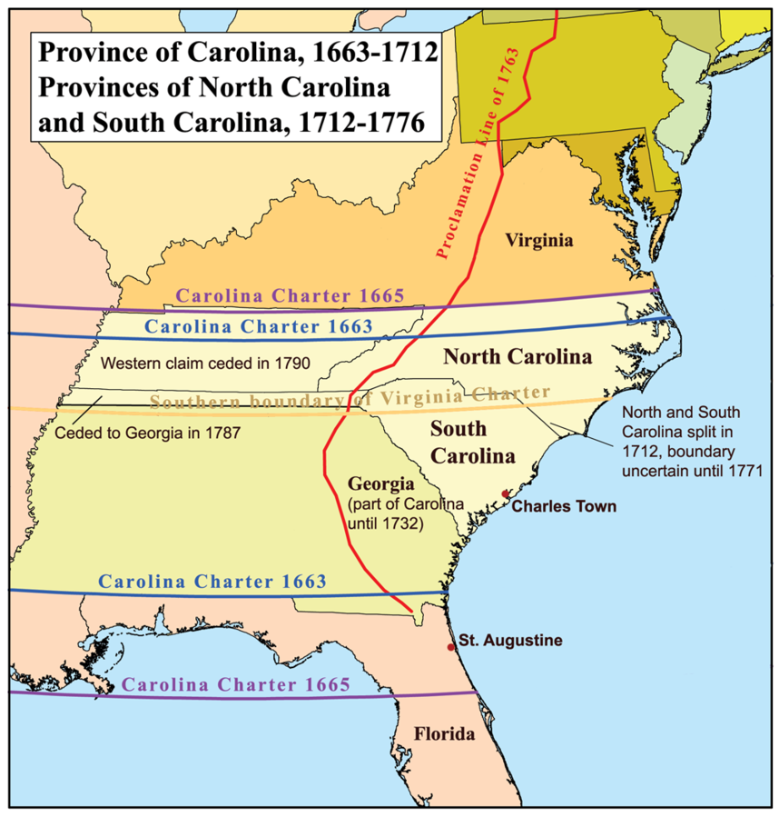
1663-1665. Carolina Charter. In 1663, King Charles II granted eight noblemen a Royal Charter to form the Province of Carolina, replacing the 1629 grant. The grant area extending from Latitude 31° (present FL/GA line) to Latitude 35° (just below Albemarle Sound). In 1665, the Carolina charter area was extended north to Latitude 36°30’ (present NC/VA line) to include the existing Albemarle Settlements; and south to Latitude 29° (just below present Daytona Beach, FL). The Carolina proprietorship was essentially a repayment for the loyalty of certain Royalists during the English Civil War, and their support of the Restoration of the Crown in 1660. The eight noblemen became known as the Lords Proprietors, and included George Monck, 1st Duke of Albemarle (1608-1670); Edward Hyde, 1st Earl of Clarendon (1609-1674); John Berkeley, 1st Baron Berkeley of Stratton (1602-1678); William Craven, 1st Earl of Craven (1608-1697); Sir George Carteret (c1610-1680); Sir William Berkeley (1605-1677); Sir John Colleton, 1st Baronet (1608-1666); and Anthony Ashley-Cooper, 1st Earl of Shaftsbury (1621-1683). The eight Lords Proprietors ran the government of the province from London, meeting regularly as an executive committee. A Fundamental Constitution of Carolina was drawn, featuring an appointed colonial governor, and a legislative body consisting of an appointed/elected Executive Council and an elected only Provincial Assembly. Province of Carolina Map Source: Creative Commons Attribution-Share Alike.
1669-1670. Carolina. In late 1669, three shiploads of colonists sailed from London, headed for Carolina. Recruited and financed by the Lords Proprietors, most of the colonists were indentured servants, willing to work as laborers for five years to pay for their passage and receive a grant of land. At Barbados, the ships were struck by a hurricane. The Albemarle was destroyed and the Port Royal and Carolina were badly damaged. In March 1670, the Carolina arrived at Bull Harbor and Sewee Bay (now South Carolina). In April, Charles Towne was founded as the capital of the Province of Carolina.
1682. Carolina. The first four counties of the Province of Carolina were created, named after Lords Proprietors Berkeley, Colleton, Craven, and Granville.
1705. Bath was the first town in present North Carolina.
1707. England and Scotland merged into the United Kingdom of Great Britain. The English Colonies now became the British Colonies.
1708-1712. Carolina’s Provincial Assembly met in Edenton, NC.
1712. Separation of North Carolina and South Carolina. The territory of the Province of Carolina since 1665 ran from Latitude 29° to the present NC/VA line (36°30’), including the area of present Georgia. In 1712, the Lords Proprietors divided Carolina into North Carolina and South Carolina as two separate proprietary provinces. The division line was nearly the same as today, but the line was not surveyed for several more years. Each province had its own colonial governor, under the authority of the eight Lords Proprietors, but the elected Council and Assembly continued to represent the area of both Carolinas. The capital of Charles Towne continued for the South Carolina/Georgia area, while the nominal capital of the North Carolina area was wherever the Provincial Assembly agreed to meet.
1715-1716. The Executive Council called for the Carolina Assembly of 1715-1716 to “…meet at the home of Capt. Richard Sanderson in Little River, instead of the Church in Chowan which was the place of ye last meeting.” – Encyclopedia of North Carolina, UNC Press.
1717. “We’re no Eerish bot Skoatch.” The arrival of the so-called Scots-Irish immigrants to the British Colonies was via Boston, New York City, Philadelphia, Alexandria, Norfolk, New Bern, and Charles Towne. The Scots-Irish (or Ulster Scots) were former border clan people who had lived near the Scottish-English border for centuries. A good number of them had moved into areas of Northern Ireland in the early 1600s, and a mass migration to most of the British colonies of America began in 1717. Up to the time of the Revolutionary War, the Scots-Irish outnumbered all other British colonists (by about four to one) with the largest numbers settling in the Piedmont region of the Old South, i.e., Virginia, North Carolina, South Carolina, and Georgia. After the Revolutionary War, later generations of the Scots-Irish were the dominate group to migrate into areas of Tennessee, Kentucky, and present West Virginia.
1721. The Province of South Carolina became a separate Royal British Colony in 1721 with a Royal Governor appointed by the King, and its own legislative body. Charles Towne was the capital.
1729. The Province of North Carolina became a separate Royal British Colony in 1729, after seven of the eight Lords Proprietors sold their interest back to the Crown. A one-eighth portion of the original proprietor land was retained by Lord John Carteret, great-grandson of Sir George Carteret, who refused to sell his share back to the Crown.
1733. The Province of Georgia was separated from South Carolina. Georgia’s first boundaries were described in its Royal Charter as “…between the Savannah and Altamaha Rivers from the Atlantic coast to the headwaters of these streams and thence to the South Seas.” The location of the headwaters of the Savannah River was misunderstood by South Carolina, who continued to claim a strip of land between North Carolina and Georgia from the Atlantic to the Mississippi River until South Carolina finally ceding the strip to Georgia in 1788 (even though the strip had been in North Carolina all along).
1742. Carteret’s Proprietorship. After some 13 years of petitions asking for a ruling, King George II finally recognized the area of Lord Carteret’s one-eighth of Carolina as a proprietorship separate from the Royal Province of North Carolina. The proclamation gave Lord John Carteret exclusive proprietary ownership of the area, which shortly thereafter would become known as the Granville District.
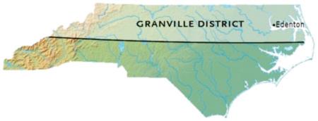
1746-1777. Granville District. John Carteret inherited the title of Earl of Granville in 1744. By 1746, he began selling land in his privately held Granville District, the northernmost 60-mile wide strip of land representing the northern half of present North Carolina. The first official survey of the Granville District described the area as lying between Latitude 35°34’ and 36°30’. At the first Granville District Land Office established in Edenton, NC, the first few years of land sales were well documented, providing good evidence of the earliest inhabitants of north-central and northwestern North Carolina into the 1760s. Later records were incomplete due to cross-claim disputes. After the death of John Carteret in 1763, most of the Granville holdings were tied up in British Chancery Court litigation for a decade, and when finally settled, the Carteret heirs were unable to reactivate the land sales due to the impending American Revolutionary War. The Granville District operation was officially dissolved in 1777, with the unsold Granville lands confiscated by the Provisional State of North Carolina – for the first time, the area of the Granville District was merged into the area of present North Carolina. After the Revolutionary War, the British Crown compensated the Carteret heirs for their loss. Map source: Univ. of North Carolina School of Education
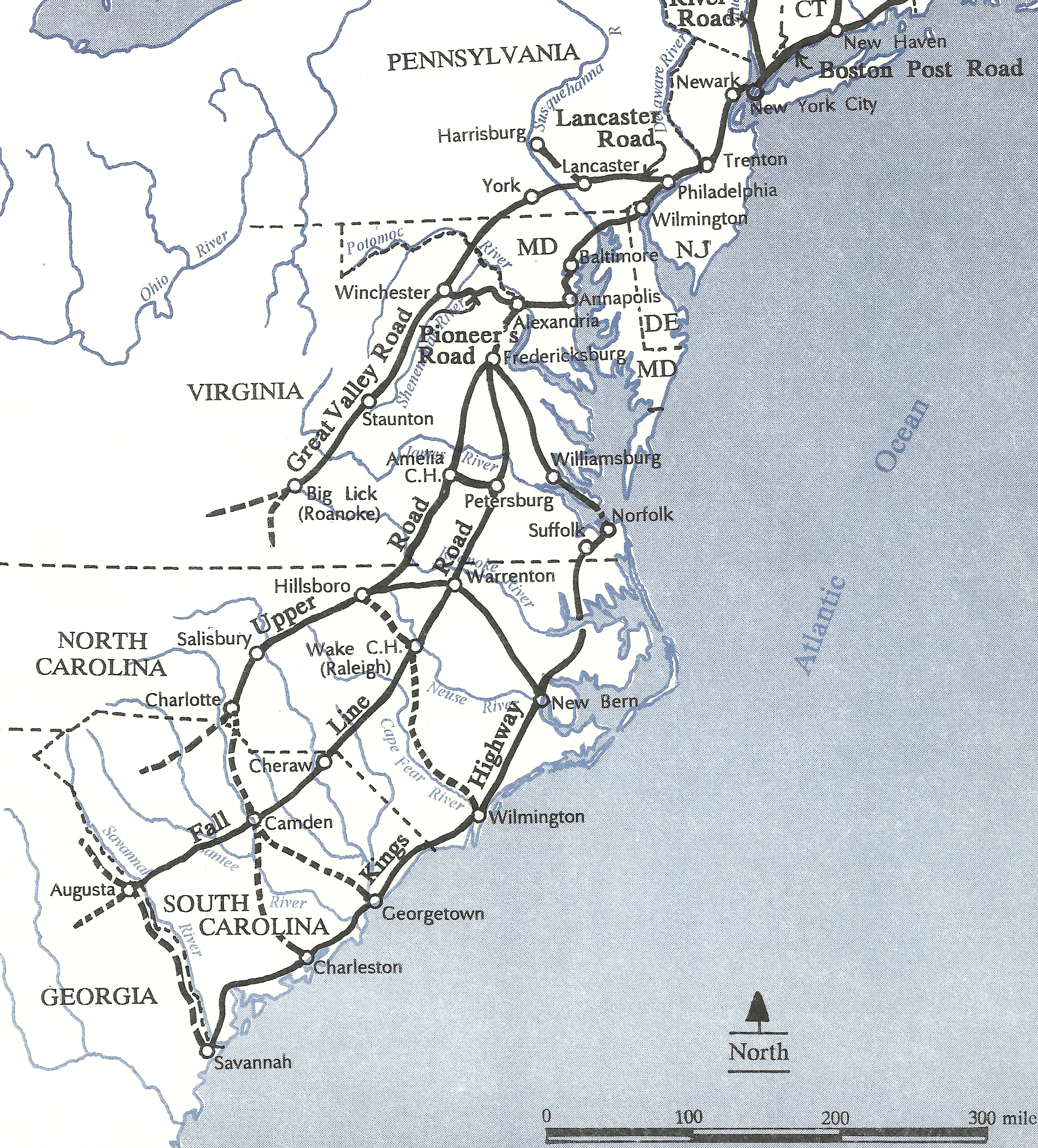
1746-1777. Colonial Wagon Roads Leading to North Carolina Before 1746, many immigrants to North Carolina came by way of the coastal seaports, such as Edenton, New Bern, or Wilmington; or via the Kings Highway, the earliest coastal wagon road. The opening of lands for sale in the Granville District in 1746 saw a strong increase in the use of the few inland wagon roads leading to North Carolina. The main migratory routes via Virginia into North Carolina were the Fall Line Road or the Upper Road. Both routes were heavily traveled by Scots-Irish immigrants. On the above map, all the roads to 1750 suitable for full horse-drawn wagons are shown as bold black lines. The bold dashed lines indicate paths suitable mostly for single-file pack teams. The Great Valley Road was often called The Irish Road by locals, because they saw mainly Scots-Irish immigrants traveling on it. By 1756, an extension to the Great Valley Road began at Big Lick (now Roanoke), entering North Carolina and joining the Upper Road between Hillsboro and Salisbury, NC. British immigration to the colonies essentially ended with the Revolutionary War. Map source: Map Guide to American Migration Routes, 1735-1815.
1754. Arthur Dobbs was named the Royal Governor of the Province of North Carolina by King George II. Dobbs served until his death in 1765. A native Scotsman, as early as 1745, Dobbs had purchased over 400,000 acres of land in North Carolina and was an advocate for the immigration to North Carolina by thousands of his Scottish kin living in Northern Ireland. His term in office matched the time of the French and Indian War in America, and as the Governor/Militia Leader, Dobbs spent nearly his entire time in office recruiting colonial soldiers to serve in military units formed from North Carolina.
1763. Proclamation Line. At the Treaty of Paris ending the French and Indian War, Great Britain gained control of all lands previously held by France east of the Mississippi River, which became the dividing line between British North America and New Spain. Soon after, King George III issued the Proclamation Line of 1763, as a way of rewarding the Indians who had helped Britain against the French. The proclamation established an Indian Reserve that stretched from the Appalachian Mountain Range to the Mississippi River – preventing the British colonists from migrating into their undeveloped western regions. The Proclamation was to become one of the “Intolerable Acts” that led to an American rebellion.
1765-1771. William Tryon was named the Royal Governor of the Province of North Carolina in 1765 by King George III. Tryon served until 1771 when he became the Royal Governor of the Province of New York. He was an adamant and loyal supporter of the British Crown and aggressively put down a rebellion of Regulators and later Patriots in North Carolina. Soon after Tryon took office in North Carolina, opposition to the Stamp Act imposed on the British Colonies created a strong common bond among the thirteen colonies, and North Carolina patriots were immediately ready to join in a general rebellion against the King. Gov. Tryon stopped any meetings of the North Carolina Assembly specifically to prevent any voting in opposition to the Stamp Act.
1766. New Bern was named the permanent capital of the Province of North Carolina. The Provincial Assembly voted to build what became Tryon Palace, colonial governor William Tryon’s mansion. The first amount allocated was £5,000; but Tryon came back later with a demand for another £5,000 – the second request had to have a new tax levied. (£10,000 in 1770 is about $1.9 million today).
1768. Treaty of Fort Stanwix. An adjustment to the Proclamation Line of 1763 took place in New York. The British government, led by Sir William Johnson, met with representatives of the Six Nations (the Iroquois) at Fort Stanwix (now Rome, NY). A new “Line of Property” was drawn, separating British Territory from Indian Territory. The new line extended the earlier proclamation line much further to the west. From Fort Stanwix, the division line ran to Fort Pitt (now Pittsburgh) and down the Ohio River to the Tennessee River, then into the present Kentucky and Tennessee regions. The Fort Stanwix treaty line effectively ceded present West Virginia and Kentucky to Virginia, and a sizable area of western North Carolina to the Tennessee River was opened for white settlement for the first time.
1768. The Regulators were organized in the North Carolina back country. Mostly farmers, they were formed in protest of excessive taxes. Though they were the earliest rebels against the Royal government in North Carolina, they more resembled a vigilante mob rather than a Sons of Liberty organization. The Regulators’ first target was Governor William Tryon, who had imposed a new tax on all North Carolinians solely for the purpose of building an elaborate home for himself.
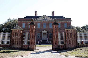
1770-1959. Tryon Palace, New Bern, NC. Gov. William Tryon insisted on building an elaborate Governors Mansion as his home in New Bern, NC, the provincial capital. The building was first occupied in 1770. The taxpayers of North Carolina had been forced to pay an added tax just to pay for the building, which became known derisively as “Tryon’s Palace.” Tryon only lived in the building for one year, and the building was captured by American rebel forces in 1775 to become the seat of government for the new Provisional State of North Carolina. But, the state determined that New Bern was not a defensible location and decided to hold their assembly sessions in various other locations for the remainder of the Revolutionary War period. A fire in 1798 destroyed most of the original Tryon Palace. After the original architectural plans were discovered, a replica of the original building was erected on the grounds and opened to the public in 1959. Photo source: Wikipedia.
1771. Gov. Tryon had seven Regulators executed after an uprising at Alamance.
1776-1781. North Carolina in the American Revolution. In 1776, North Carolina was the first British Colony to vote for independence. The state’s first American Revolution battle was fought at Moores Creek Bridge (1776). Other significant battles in North Carolina were the Battles of Kings Mountain (1780), Guilford Court House (1781), and Eutaw Springs (1781), all battles that secured the southern front for the Americans, and led the way to their final victory at Yorktown, Virginia (1781)
1783. Treaty of Paris. The United States of America was recognized as an independent nation. Signers of the treaty included Great Britain, Spain, and France.
1784. State of Franklin. Feeling cut off from their government in New Bern, North Carolina, settlers living in present Northeastern Tennessee declared their area an independent state and named it Franklin. Jonesborough was their capital. Franklin functioned as a state for four years with the consent of the local population. But in 1788, Franklin’s petition to Congress for official recognition was denied. The area was reclaimed by North Carolina where it remained until the Southwest Territory was formed in 1790.
1784-1787. NC State Census. In 1784, an act of the Provisional North Carolina General Assembly asked each of the county courts for a list of inhabitants, which was completed for all counties between 1785 and 1787. That enumeration made North Carolina one of 38 state census states. But, North Carolina has not taken a state-sponsored census since. Land records, tax lists, and other name lists provide substitutes for the entire state.
1789. Nov 21. Upon ratification of the U.S. Constitution, North Carolina became the 12th state in the Union, with the state capital at New Bern.
1790. May. North Carolina ceded to the U.S. Government the area that became the Territory Southwest of the River Ohio. The Southwest Territory became the state of Tennessee in 1796.
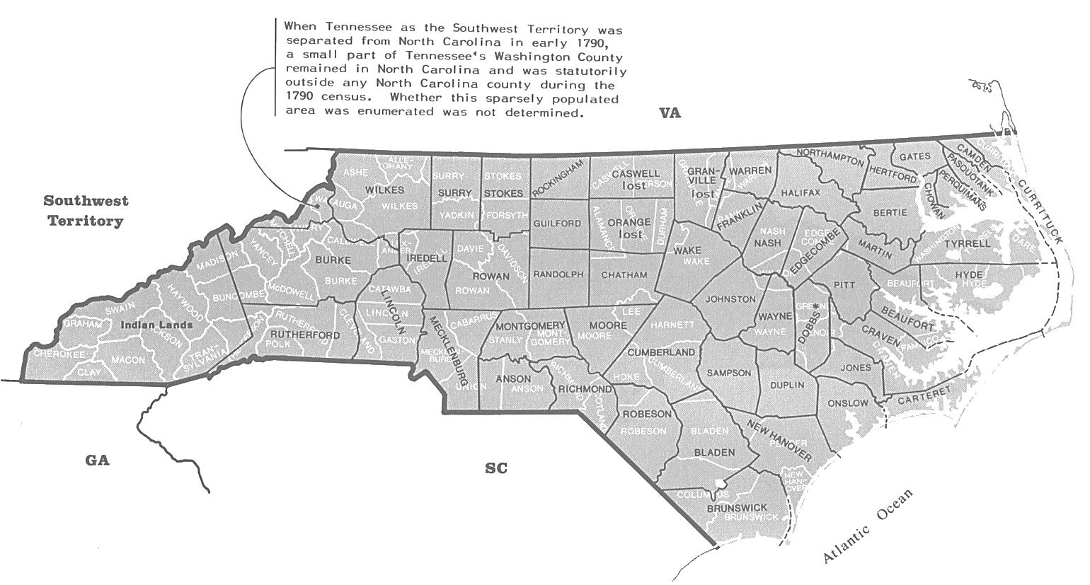
1790. Aug. Federal Census of North Carolina. The map above shows in black the 53 counties of North Carolina at the time of the 1790 Federal Census. The current 100 counties of North Carolina are shown in white. The 1790 federal census is extant for all counties except Caswell, Granville, and Orange, shown as “lost” on the map. Those three counties were reconstructed from tax lists in the Census Bureau’s 1790 Heads of Families publication. NOTE: The area of the Granville District, 1746-1777, can be visualized by following the boundary line between Tyrrell and Hyde counties. Extend that line to the western end of North Carolina. The area of the Granville District contained all or parts of 31 of the 53 counties in place in 1790 (lines in black). Today, 51 of North Carolina’s 100 counties were once part of the old Granville District (lines in white). Map Source: Map Guide to the U.S. Federal Censuses, 1790-1920, page 228.
1794. North Carolina. The capital of North Carolina was moved from New Bern to Raleigh.
Further Reading:
North Carolina Censuses & Substitute Name Lists, 1660-2011 (Printed Book), Softbound, 81 pages, Item FR0275.
North Carolina Censuses & Substitute Name Lists, 1660-2011 (PDF eBook), 81 pages, Item FR0276.
Online North Carolina Censuses & Substitutes: A Genealogists’ Insta-Guide™, Laminated, 4 pages, 3-hole punched, Item FR0345.
Online North Carolina Censuses & Substitutes: A Genealogists’ Insta-Guide™ (PDF version), 4-pages, Item FR0346.
The Granville District of North Carolina, 1748-1763: Abstracts of Land Grants, 5 vols., compiled by Margaret M. Hofmann, orig. publ. 1986, Roanoke News; single vols. reprinted by various publishers. This valuable publication provides abstracts of the land records naming land buyers, agents/sellers, disputes/court cases, and claims for nearly all land grants issued by the Land Office of the Granville District up to the year of Lord Granville’s death in 1763. The Family History Library catalog has the 5-vol. set, but with no description of the contents. Check the WorldCat website for other possible copy locations; and also check for this title at Amazon.com or Books.Google.com for detailed descriptions and availability of used copies for sale.