The following article is by my good friend, Bill Dollarhide, taken from his book, Kentucky Name Lists: Published and Online Censuses & Substitutes, 1773-2000. 
Prologue: The highlighted events of this historical timeline for Kentucky are focused on the first visitors to the region, the colonial period when Kentucky was part of old Virginia, and the subsequent jurisdictional changes that evolved. The goal is to give genealogists a sense of the jurisdictions in place at the time an ancestor lived there:
1541. Spanish conquistador Hernando DeSoto visited present Kentucky. Accounts of his expedition described the Indians native to the western region of Kentucky between the Tennessee and Mississippi Rivers. Veterans of the 1532-1535 battles with the Inca Indians of South America, DeSoto and his men were the first Europeans to travel inland within America. Starting in 1539 from Havana, they landed on the west coast of present Florida, passing through the central areas of Georgia, the Carolinas, Alabama, Tennessee, Kentucky, Mississippi, and Arkansas. Looking for gold and a route to China, his party began with some 620 men, 500 beef cattle, 250 horses and 200 pigs. DeSoto had great success routing the Inca warriors with his charging horses, but his horses did not scare the natives of North America. Nearly half of his men and horses were killed in several disastrous skirmishes with the Creek Indians of present Georgia. After three years exploring the area from present Georgia to Arkansas, DeSoto died from fever and was buried in the Mississippi River at a point south of present Memphis. About 300 men of the DeSoto party managed to survive and eventually made their way to Mexico City.
1739. Captain Charles de Longueuil was a commander of a French-Canadian military expedition against the Indians along the Ohio River. During the expedition, he discovered the region of Big Bone Lick, now Boone County, Kentucky.
1750. Dr. Thomas Walker, a physician from Virginia, explored the Kentucky region via the Cumberland River. His party of five men were the first Englishmen to see the area. They were also the first to erect a cabin in the region.
1763. Treaty of Paris ended the French and Indian War (in Europe and Canada: the Seven Years War). France ceded land, including Kentucky, to Britain. Soon after, King George III declared the “Proclamation Line of 1763,” as a way of rewarding the Indians who had helped Britain against the French. The proclamation established an Indian Reserve that stretched from the Appalachian Mountain Range to the Mississippi River. A record of Kentuckians who fought in militia units of Virginia during the French and Indian War can be found at the Kentucky Secretary of State office. See my earlier Blog article, About Kentucky’s Land Records, for details.
1768. Treaty of Fort Stanwix. An adjustment to the Proclamation Line of 1763 was to have a dramatic impact on the area of Kentucky. The British government, led by Sir William Johnson, met with representatives of the Six Nations (the Iroquois) at Fort Stanwix (now Rome, NY). A new “Line of Property” was drawn, separating British Colonial Territory from Six Nations Territory. The new line extended the earlier proclamation line of the Alleghenies much further to the west. Beginning at Fort Stanwix, the division line ran to Fort Pitt (now Pittsburgh) and down the Ohio River to the Tennessee River, then into the present Tennessee region. The Fort Stanwix treaty line effectively ceded most of present West Virginia and Kentucky to the British Colony of Virginia.
1769-1772. The Colony of Virginia saw the Treaty of Fort Stanwix as an opportunity to open up settlement to its western lands. Beginning in 1769, land surveys were conducted in the Kanawha, Kentucky, and Cumberland River valleys In 1772, Fincastle County, Virginia was created. The area extended from the present western line of Virginia with West Virginia to the Mississippi River. The area included all of the present area of Kentucky. Access to Fincastle county was via the Ohio River, then to one of the tributaries into present West Virginia or Kentucky.
1774. Lord Dunmore’s War. This was a war between the Virginia militia and the Shawnee and Mingo Indians. Due to the attacks against British colonists moving into the lands south of the Ohio River, the Governor of Virginia, John Murray, 4th Earl of Dunmore, asked the Virginia House of Burgesses to declare a state of war with the hostile Indian tribes. Dunmore said that Virginians needed to defend their legal right based on the 1768 Treaty of Fort Stanwix. Militia was drawn from all of Virginia, including the Kentucky region of Fincastle County. The war ended after Dunmore’s victory at the Battle of Point Pleasant (mouth of the Kanawha River on the Ohio River) in October 1774. In the resulting treaty, the Indians lost the right to hunt in the area south of the Ohio River. Thus, Lord Dunmore’s War opened the way for an all-out effort to bring settlers into the western areas of Virginia.
1774. Harrodstown (later Harrodsburg) was established as the first settlement in the Kentucky region. Named after James Harrod, who led a group of surveyors into the region, Harrodstown was immediately attacked by Indians and abandoned, but was resettled the following year. The city today is the county seat of Mercer County, Kentucky.
1775. Richard Henderson, a North Carolina judge heading up the Transylvania Company, met with three Cherokee Chiefs to purchase all the land lying between the Ohio, Kentucky, and Cumberland Rivers—about 20 million acres and about half of the present area of Kentucky. It become known as The Henderson Purchase. Henderson was intent on establishing the Transylvania Colony, with hopes of gaining recognition as a proprietary British colony. However, the Transylvania Company was invalidated by the Virginia Assembly in 1776. Most of the ownership of land in the Kentucky region was reverted back to Virginia until the new state of Kentucky acquired title to any unsold land in 1792.
1775. Wilderness Trail. In 1775, a party of 36 men and two women led by pioneer Daniel Boone blazed the Wilderness Trail to establish Fort Boonesborough in present-day Madison County. Boone was hired by Richard Henderson to found the first settlement of the Transylvania Colony. After the initial trail-head at present Kingsport, Tennessee the trail connected to Shelby’s Fort (later Sapling Grove, then Bristol, TN/VA), which became the starting point of the Wilderness Trail. The trail crossed the Cumberland Mountains via the Cumberland Gap. It is estimated that between 1775 and 1783, over 40,000 people migrated into Kentucky using the Wilderness Trail. From 1775 to 1796, the path was passable only by single-file pack teams. Daniel Boone’s greatest contribution to America was the settlement of an area west of the Alleghenies. Partly as a result of the many settlements established in the Kentucky region before the Treaty of Paris of 1783, the entire region west of the Appalachian Mountain Range to the Mississippi River was ceded by the British to the new United States of America.
1775. Felix Walker, one of Daniel Boone’s road cutters on the Wilderness Trail in 1775 had this to say about the experience, “…on leaving that river [the Rockcastle], we had to encounter and cut our way through a country of about twenty miles, entirely covered with dead brush, which we found a difficult and laborious task. At the end of which we arrived at the commencement of a cane country, traveled about thirty miles through thick cane and reed, and as the cane ceased, we began to discover the pleasing and rapturous appearance of the plains of Kentucky. A new sky and strange earth seemed to be presented to our view. So rich a soil we had never seen before – covered with clover in full bloom, the woods were abounding with wild game – turkeys so numerous that it might be said they appeared but one flock, universally scattered in the woods….” From Felix Walker’s Narrative, (Filson Club First Publication Series, Number 16, Louisville, 1901), pp163-64.).
1776. December 31st. The county name Fincastle was dropped, and the area was divided into three new counties by the Commonwealth of Virginia: Kentucky County, Washington County, and Montgomery County. The boundaries of Kentucky County in 1776 matched the modern boundaries of the state of Kentucky except for the extreme western region still under control of the Chickasaw Indians.
1780. June 30th. The name Kentucky was dropped and the area was carved into Fayette, Jefferson, and Lincoln counties, Virginia. Most of the settlers in those three counties, however, still referred to their home as “Kentucky.”
1784. The first of 10 conventions to discuss the separation of the Kentucky region from Virginia was held at Danville, Kentucky. Three main factors contributed to their desire to separate from Virginia: 1) Traveling to the state capital in Richmond was long and dangerous. 2) Any use of the local militia against the Indians required authorization from the Governor of Virginia. And 3), Virginia refused to recognize the importance of trade along the Mississippi and Ohio Rivers to Kentucky’s economy.
1789. Perhaps a bit of folklore rather than history, Baptist minister Elijah Craig of Kentucky is said to have made the first bourbon whiskey, distilled from corn and aged in charred oak casks. Today, 95 percent of the world’s bourbon is distilled and aged in Kentucky. The current population of Kentucky, about 4.4 million people, is exceeded by the 4.9 million barrels of bourbon whiskey being aged in Kentucky rack houses.
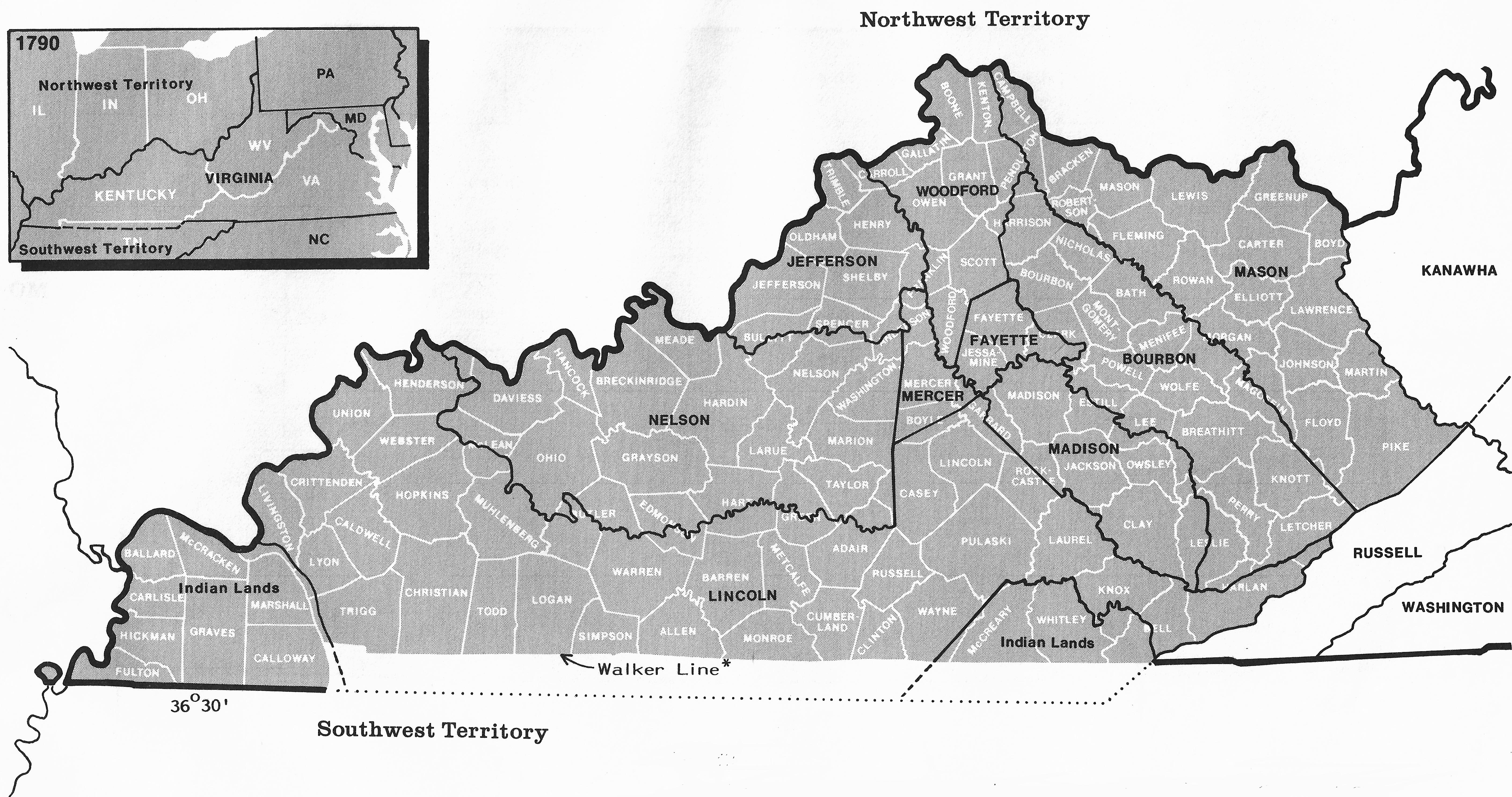
1790. August 2nd. The 1790 Map above shows the area of Virginia that became Kentucky in 1792. The 1790 Federal Census showed a population of 73,677 people living in the Kentucky region. African-American slaves comprised 16 percent of Kentucky’s population; and slave labor was an integral part of the region, particularly in the central area with its rich farmlands. Although still part of Virginia in 1790, the Kentucky region had its own U.S. Circuit Court, the jurisdiction for all federal censuses, 1790-1870. Kentucky’s 1790 circuit court district boundaries matched the present state boundaries. The 1790 census was taken in the name of “Kentucky,” even though that name did not become official again until statehood two years later. Kentucky’s 1790 census name lists were lost. In 1830, a federal law asked for the return of all original census manuscripts, 1790-1820 to Washington, DC, from each of the U.S. Circuit Court Clerks in the U.S., but apparently, the Kentucky Circuit Court Clerk could not comply. (Map Source: Map Guide to the U.S. Federal Censuses, 1790-1920).
1792. June 1. Kentucky became the 15th state admitted to the Union. The population of Kentucky in 1792 was about 90,000 people.
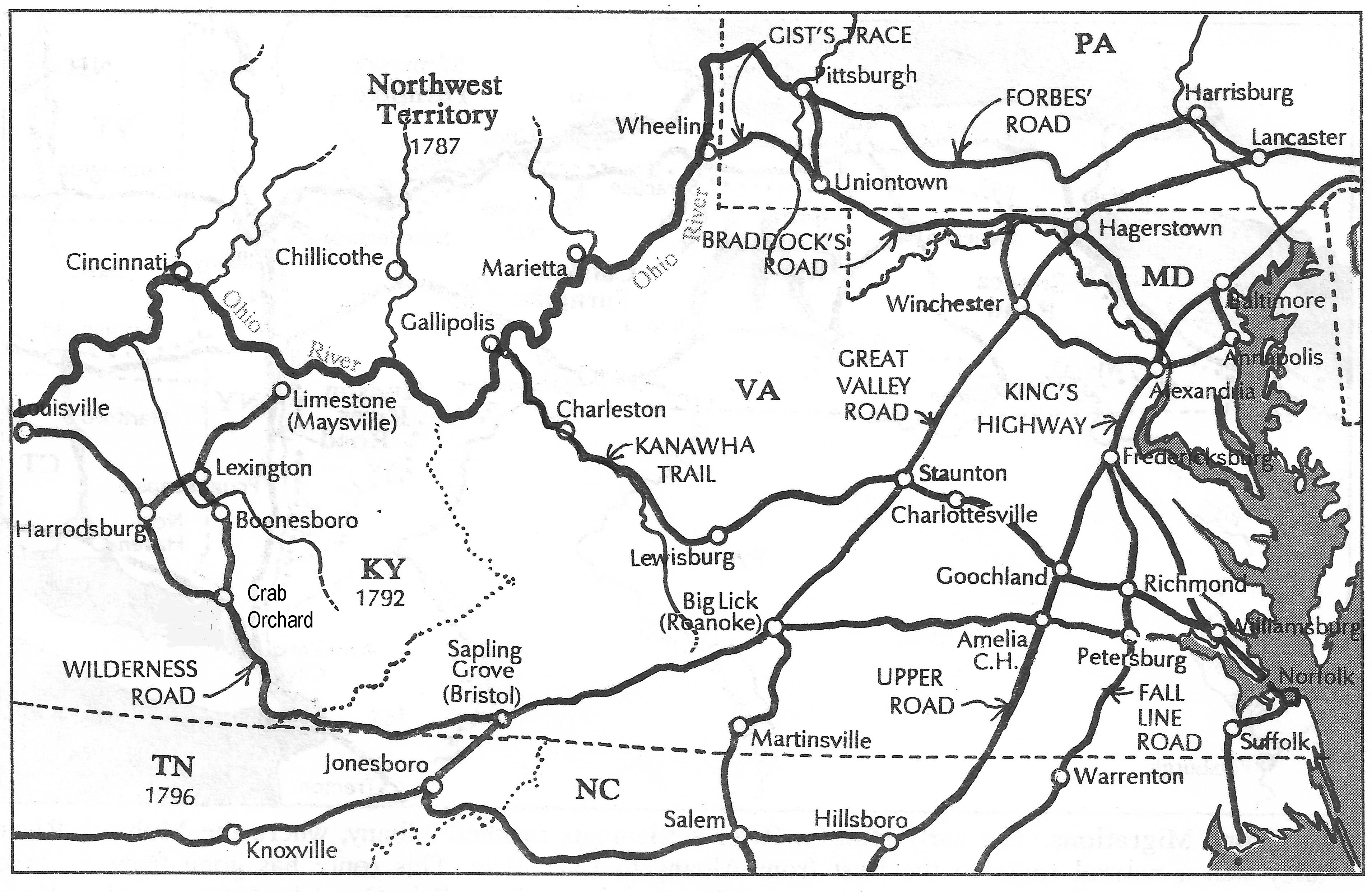
1796. Wilderness Road. Soon after statehood the state of Kentucky began planning for the widening and grading of the Wilderness Trail to allow horse-drawn wagons to negotiate the roadway. The first wagons appeared on the road in 1796, and the Wilderness Road immediately became the primary access to the interior of Kentucky. The improved route now had a fork at Crab Orchard. One could angle right to head for Boonesboro on the original Wilderness Trail. From there, the road to Lexington continued to Limestone at the Ohio River. Or, one could angle left at Crab Orchard (on Logan’s Trace) and head to Harrodsburg; and then on to Louisville at the Ohio River. By 1810, over 300,000 people had come to Kentucky by way of the Wilderness Road. (Map Source: Map Guide to American Migration Routes, 1735-1815).
1800. August 4th . The second Federal Census showed a population of 220,955 people living in Kentucky, three times the 1790 total. Like the 1790, the 1800 census name lists were lost.
1801. An estimated 20,000 people attended the great church camp meeting at Cane Ridge (Bourbon County, Kentucky), the single largest event of the Second Great Awakening. What ensued was a period of emotional religious revivals that took place all across the country. The leaders of the revivals – the Methodists and Baptists – grew rapidly. The Christian Church, Church of Christ, and the Disciples of Christ were founded as a direct result of the revivals.
1810. August 6th . The third Federal Census showed a population of 406,511 people living in Kentucky, nearly double the number in 1800. The 1810 KY census was the first for which the original name lists have survived.
1811-1812. Western Kentucky was heavily damaged by the New Madrid earthquakes, the most intense recorded earthquakes in the contiguous United States. They caused the Mississippi River to change course and created the “Kentucky Bend,” an enclave of Fulton County, Kentucky, surrounded on three sides by Missouri, and an interrupted extension of the Kentucky/Tennessee line at Latitude 36°30’.
1818. The Jackson Purchase. Under President Andrew Jackson, the U.S. government purchased areas of Kentucky and Tennessee from the Chickasaw Indians in the Treaty of Tuscaloosa. The portion situated in Kentucky was thereafter called “The Jackson Purchase.” This was the last Indian Cession in the state of Kentucky. Refer to my earlier Blog article, About Kentucky’s Land Records.
1861. April 12th. Civil War. Kentucky never seceded from the Union and was officially neutral at the beginning of the war. After a failed attempt by Confederate General Leonidas Polk to take the state of Kentucky for the Confederacy, the legislature petitioned the Union for assistance, and thereafter became solidly under Union control. The amount of support for the North or South was reflected in the number of troops supplied to either side – Kentucky supplied 86,000 troops to the north and 40,000 troops to the south. Ironically, Kentucky was the birthplace of both the Union president, Abraham Lincoln, and the Confederate president, Jefferson Davis.
1875. The first Kentucky Derby was held at Churchill Downs in Louisville, Kentucky. The race still occurs annually on the first Saturday in May and is the most attended horse race in North America. The Kentucky Derby later became part of the Triple Crown with the Preakness and Belmont Stakes.
1878. The Hatfield-McCoy feud involved two warring families of West Virginia and Kentucky back-country. The feud began over a pig and escalated into murder, claiming the lives of more than a dozen members of the two families. It becomes headline news around the country, and compelled the two states’ governors to employ state militias to restore order. The families agreed to stop fighting in 1891.
1934. Harland Sanders created a recipe for fried chicken for his Sanders Court & Café in Corbin, Kentucky. The restaurant was so successful that in 1936 Governor Ruby Laffoon granted Sanders the title of honorary “Kentucky Colonel.” Sanders then founded Kentucky Fried Chicken in 1952.
1998. At the invitation of the Kentucky Genealogical Society, William Dollarhide presented lectures at a genealogical seminar held in Frankfort, Kentucky. During his brief stay, he was taken by KGS members to the State Burial Grounds of the Frankfort Cemetery, where a grave marker for Col. Thomas Dollarhide was photographed, along with one for Daniel Boone, buried a few feet away. Originally from the Clinch River Valley of Southwest Virginia, Thomas Dollarhide had moved into Kentucky in the early 1790s. After 1800, Thomas lived near Somerset, Kentucky, where he became involved in community affairs, and where he commanded a regiment of Kentucky Militia in 1815. He was an elected state senator from Pulaski County, and died in office in 1820. He was originally buried in the family burial grounds near Somerset. In 1845, the Kentucky General Assembly authorized a reburial and special gravestone for Col. Thomas Dollarhide at the new State Burial Grounds tract within Frankfort Cemetery. The Governor of Kentucky granted the title of “Kentucky Colonel” to William Dollarhide, who returned home a couple of days later, but the real Kentucky Colonel never left the state.
Further Reading:
Kentucky Name Lists: Published and Online Censuses & Substitutes, 1773-2000. (Printed Book), softbound, 91 pages, Item FR0243.
Kentucky Name Lists: Published and Online Censuses & Substitutes, 1723-2000. (PDF eBook), 91 pages, Item FR0244.
Online Kentucky Name Lists: A Genealogists’ Insta-Guide™, laminated, 3-hole punched, Item FR0311.
About Kentucky’s Land Records, a GenealogyBlog article by William Dollarhide.