The following article was written by my good friend, William Dollarhide, and was taken from his book, Minnesota Censuses & Substitute Name Lists, 1830-2002.
The area of present Minnesota east of the Mississippi River was included in the formation of the United States per the Treaty of Paris of 1783. The western area of Minnesota was part of la Louisiane Française, 1717-1762; part of Spanish Louisiana, 1762-1802; part of (Napoleon’s) Louisiana, 1802-1803; and part of the Louisiana Purchase of 1803, when the rest of Minnesota became American territory. This historical timeline of Minnesota identifies the main jurisdictions and how they evolved. The goal here is to give genealogists a sense of the jurisdictions in place at the time an ancestor lived in Minnesota. Understanding the jurisdiction where the records may be located today is half the battle in genealogical research.
1612-1615. French explorers Etienne Brule and Samuel de Champlain were the first Europeans to see the Great Lakes. Brule explored Lake Huron in 1612. He was followed by Champlain in 1615.
1682. French Louisiana. René-Robert Cavelier (Sieur de LaSalle) erected a cross near the confluence of the Mississippi River and the Gulf of Mexico, after floating down river from the Illinois Country. He claimed the entire Mississippi Basin for Louis XIV of France, for whom Louisiana was named. All of the rivers and streams flowing into the Mississippi were part of the Mississippi Basin and included in the Louisiana claim.
1717. French Louisiana. The Illinois Country was officially added to the French Louisiana jurisdiction within New France. At that time la Louisiane Française extended from the Wabash River, down the Ohio and Mississippi Rivers to include several ports on the Gulf of Mexico. Any trading posts or forts north of the Highlands (Terra Haute) were administered as part of French Québec.
1763. Treaty of Paris. This was the end of the French and Indian war. (In Europe it was called the “Seven Years War.”) At the 1763 Treaty, the French surrendered all their claims in North America. Spain acquired the former French areas west of the Mississippi, renamed Spanish Louisiana. Great Britain gained all of Québec, which they immediately renamed the Province of Canada. Britain also gained control of the rest of North America east of the Mississippi River. They named their entire area British North America.
1774. Québec Act. In response to increased American colonial rebellions, the British sought to solidify loyalty from their French communities in British Canada. The British Parliament passed the Québec Act, which restored the name Province of Québec, allowed the French Canadians to retain French laws and customs, and permitted the Catholic Church to maintain all of its rights. Taken from the original clams of the thirteen colonies, the entire region of the Old Northwest was added to Québec, now under British rule.
1783. The Treaty of Paris recognized the United States of America as an independent nation and defined its borders from the Atlantic Ocean to the Mississippi River. Although the settlements in the Great Lakes region were to be included within the United States, British military forces continued to maintain control over parts of the Great Lakes area for several years after the Revolution. Notably, Fort Detroit remained in British control until 1796. And, Prairie du Chien, on the Mississippi River at the mouth of the Wisconsin River, was a strategic post that did not become American until after the War of 1812. The Isle Royale in Lake Superior was a mustering point for the British and their allied Indians, and also remained in British control until after the War of 1812.
1784. Ohio Country. Connecticut, Virginia and Massachusetts relinquished their claim to lands in the Ohio Country. Title transferred to the “public domain” of the United States Government. Connecticut retained ownership of the “Western Reserve” on Lake Erie, then sold the tract to the Connecticut Land Company in 1795.
1787. Jul 13. Northwest Territory. The Ordinance of 1787 established the Territory Northwest of the River Ohio, and defined the procedure for any territory to obtain statehood. Present states carved out of the original area of the Northwest Territory include Ohio, Indiana, Illinois, Michigan, Wisconsin, and that part of Minnesota east of the Mississippi River.
1800-1803. Louisiana. In 1800, Napoleon gained title to Louisiana again after trading Spain a duchy in Italy. However, Napoleon’s troops in the Caribbean were under siege and unable to provide any help in establishing a French government in Louisiana. Several months later, when American emissaries showed up trying to buy New Orleans, Napoleon offered the entire tract to them. In 1803, President Thomas Jefferson urged Congress to vote in favor, and the U.S. purchased the huge tract from France, doubling the size of the United States.
1804. Louisiana District. The Louisiana Purchase was described legally as “the drainage of the Mississippi and Missouri Rivers.” In 1804, Orleans Territory and Louisiana District were created. Louisiana District included that portion of present-day Minnesota west of the Mississippi River.
1814. Treaty of Ghent. The War of 1812 ended, freeing up American settlement of the Old Northwest.
1818. Anglo American Convention. At this treaty with Britain, the northern U.S. boundary was set at the 49th parallel, from the Lake of the Woods (now Minnesota) to the Continental Divide. The land cession from Britain to the U.S. included the Red River drainage of present western Minnesota and eastern North Dakota. Left out of the 1818 treaty line was the U.S.-British boundary line east of the Lake of the Woods to Lake Superior (now called the Northwest Angle), a line that was not finally settled until the Webster-Ashburton Treaty of 1842.
– Also in 1818, the northern portions of both Illinois Territory and Indiana Territory were added to Michigan Territory, which now stretched across the Great Lakes region from Lake Erie to the Mississippi River, including the part of present Minnesota east of the Mississippi.
1819-1824. Fort Snelling. The first American presence in the Minnesota area was at Fort St. Anthony, founded by the U.S. Army in 1819 at the confluence of the Minnesota and Mississippi Rivers (between present St. Paul and Minneapolis). The first steamboat to navigate the Mississippi into present Minnesota arrived at Fort St. Anthony in May 1823. The fort was renamed Fort Snelling in 1824, to honor its first commander and architect.
1832. Henry Schoolcraft discovered the source of the Mississippi River in present central Minnesota, a lake he named Itasca.
1836. Wisconsin Territory was created in 1836, taken from Michigan Territory. Its area included the lands of present Wisconsin, and extended west to the Missouri River, including all of present Minnesota.
1838. Iowa Territory was created, reducing the western area of Wisconsin Territory to end at the Mississippi River. Fort Snelling, on the west side of the Mississippi River, was now in Clayton County, Iowa Territory.
1840. Federal Census. Population within the areas of present Minnesota included a few residents of St. Croix County, Wisconsin Territory, and Clayton County, Iowa Territory. A few fur traders located in Lake Pepin Precinct (near present Wabasha) were named in the census. But, the 96 inhabitants of Fort Snelling, also in Clayton County, Iowa Territory, were counted but not named.
1844. Iron ore was discovered in the Mesabi Range, the first of several more iron ranges that would become known as the Iron Range of Minnesota, the largest iron ore mining district in the U.S.
1848. Wisconsin became a state with the same boundaries as today. After statehood, the residents of the area between the Mississippi and St. Croix rivers (present-day eastern Minnesota) were left without a territorial government or legal system. About 4,500 people were living in the area of the present Minnesota counties of Benton, Ramsey, and Washington. They immediately began petitioning Congress to become a territory.
1849. Mar 3. Minnesota Territory was created by Congress, with St. Paul as the territorial capital. The original area included the area of present Minnesota, extending west to the Missouri River, including that portion of present North and South Dakota east of the Missouri River.
1856. St. Paul – The Tourist Trap. After the completion of the Rock Island Railroad in 1854, Mississippi steamboats were making regular trips with “pleasure parties” between Rock Island, Illinois and St. Paul, Minnesota. St. Paul had become somewhat of a summer resort destination for southerners. Grand hotels were built, and in 1856, the local newspaper noted that 56,000 tourists had visited St. Paul by steamboat.
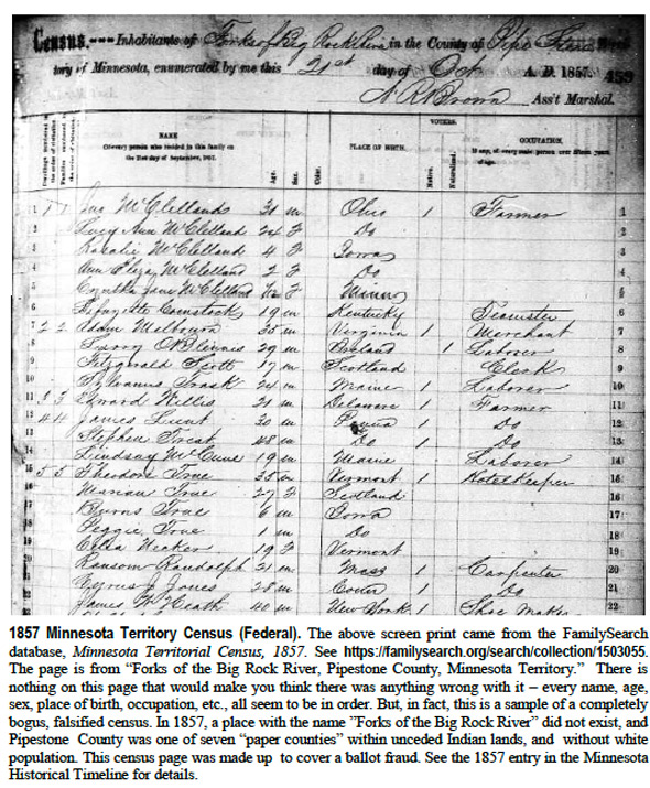
1857. Minnesota Territory Census. Congress was expecting a petition for statehood from Minnesota Territory, who claimed a population sufficient to meet minimum requirements (over 60,000). Congress was skeptical about the numbers, due to known balloting frauds in Minnesota Territory, where thousands of fictitious voters had elected several members into the territorial legislature. In a rare move, the federal government mandated a territorial census to be taken, financed by the federal government, but using local census takers. The 1857 Minnesota Territory census was a huge success for the territory, and with the figures of over 150,000 people counted in 1857, Minnesota’s petition for statehood sailed through Congress the following year. In the early 1930s, historian Robert J. Forrest was examining the original 1857 census pages and made a remarkable discovery: the census pages included thousands of names of persons living in seven counties in southwest Minnesota – seven counties that had no population in 1857. Further research revealed that seven paper counties (Cottonwood, Jackson, Martin, Murray, Nobles, Pipestone, and Rock) had no population, but Democrats had fabricated census schedules complete with names, ages, occupations, etc. Having previously stuffed ballot boxes with made-up names of voters, the census schedules were fraudulently created to cover their ballot fraud. For the history of this bogus census, see Robert J. Forrest’s article, “Mythical Cities of Southwestern Minnesota,” in Minnesota History, Vol. 14 (1933), pp243-52. In spite of some interesting anomalies, the 1857 Minnesota Territory Census is complete, microfilmed, digitized, and indexed online at FamilySearch.org, both real and bogus names included.
1858. May 11. Minnesota became the 32nd state admitted to the Union, with boundaries the same as today. St. Paul was the state capital.
1860. Federal Census. Minnesota’s first statewide federal census revealed a population of 172,023 people. The areas formerly part of Minnesota Territory west of the Red River were enumerated in the 1860 federal census as Unorganized Dakota.
Further Reading:
- Minnesota Censuses & Substitute Name Lists, 1830-2002, 81 pages, softbound, Item FR0255.
- Minnesota Censuses & Substitute Name Lists, 1830-2002 (PDF Version), 81 pages, Item FR0256.
- Minnesota Censuses & Substitutes, a Genealogists’ Insta-GuideTM, 4-page, laminated, Item FR0325.
- Minnesota Censuses & Substitutes, a Genealogists’ Insta-GuideTM, (PDF version), 4 pp, Item FR0326.