The following is excerpted from Bill Dollarhide’s new Hawaii Name Lists 1700s-2011 book.
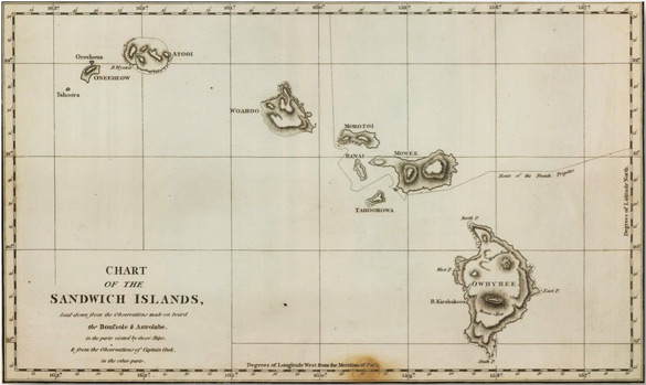
Chart of the Sandwich Islands, by Jean-Francois de Galaup de La Pèrouse (1741-1788). The original chart was prepared by Pèrouse while visiting Hawaii in 1785. The above chart was published in 1799 by G.G. & J. Robinson, London. Full title: “Chart of the Sandwich Islands, laid down from the observations made aboard the Boussole & Astrolabe, in the parts visited by those ships, & from the Observations of Captain Cook, in the other parts.” From a copy of the original map at the David Rumsey Historical Map Collection. See www.davidrumsey.com.
History: from Five Centuries of Sailing Ships: From the Santa Maria to the Glomar Explorer, by Robert G. Albion, published by McGraw-Hill, New York, 1979:
“ . . .Boussole & Astrolabe. Jean François de Galaup de La Pèrouse was a full-time professional naval officer. He had had brilliant if lonesome duty during the American Revolution with a strong squadron up in Hudson’s Bay, where he captured the two principal Hudson’s Bay Company’s posts. After the war La Pèrouse, as one of the most promising of the regular officers, was appointed to follow up Cook’s explorations. For this scientific mission he was given two substantial frigates, the Boussole and Astrolabe.
“. . . The expedition sailed from Brest on August 1, 1785. Touching at Chile, they proceeded to Easter Island and then to Hawaii. Running from Alaska, they followed the American coast down as far as Monterey and, at the turn of the year, reached Macao and Manila. To preserve his story for posterity, La Pèrouse sent his journals (and the above Chart of the Sandwich Islands) overland to Paris. His next stop was Samoa, an unfortunate one. The captain of the Astrolabe, was attacked by a Samoan mob, and he and 11 others were killed and 20 were seriously wounded. At the turn of the year, La Pèrouse visited Tonga and called at Botany Bay in Australia. On March 11, 1788, the Boussole and Astrolabe sailed, and that was the last that was heard of them.”
It was years later that the fate of both ships was learned. In 1827, the commander of a British ship found clues to the fate of the Boussole and Astrolabe frigates on the island of Vanikoro, Santa Cruz Islands (now part of the Solomon Islands, South Pacific Ocean). The two ships had driven ashore in a fierce storm. One of them hit a reef and became a total loss; the other drove over a reef and considerable material was salvaged. The survivors built a smaller vessel from the wreckage and sailed away, leaving only a few survivors on Vanikoro. Copyright-free text from the Five Centuries of Sailing Ships book is available online. See
http://www.gyford.com/archive/2009/04/28/www.geocities.com/TheTropics/Shores/1258/copy.html.
To learn more about Bill Dollarhide’s new Hawaii Name Lists, 1700s – 2011 volume, click on the following links:
Hawaii Name Lists, 1700s – 2011, With A Selection Of National Name Lists, 1600s – Present