The following Historical Timeline for Arizona, 1100 – 1912 is excepted from Bill’s new book, Arizona Name Lists 1684 – 2003, with a selection of National Name Lists, 1600s – Present:

For genealogical research in Arizona, the following timeline of events should help any genealogist understand the area with an historical and genealogical point of view:
1100 AD. The Hopi village of Oraibi was founded. It may be the oldest continuously inhabited settlement within the United States. The Hopi Reservation is in Arizona’s Navajo County, completely surrounded by the Navajo Reservation.
1536. Spanish explorer Cabeza de Vaca entered the area of present New Mexico via Texas. He was credited with first telling the story of the Seven Cities of Cibola (or Seven Cities of Gold). The local natives perpetuated the rumor, by continually telling the Spaniards that the cities of gold were just a little further away. This ploy worked for nearly 60 years, keeping the Spanish soldiers from staying very long in one place.
1539. Franciscan friar Marcos de Niza and his black slave Esteban de Dorantes explored Nuevo Mexico looking for the Seven Cities of Cibola. They reached the Zuni village of Hawikuh (near the present Arizona border with New Mexico), where Esteban was killed.
1540. Francisco Vasquez de Coronado of Spain came searching for the Seven Cities of Cibola. Coronado
never found the cities of gold, but he did find the Gulf of California, the Colorado River, the Grand Canyon, parts of present southern Utah and Colorado, and a piece of southwest Kansas. He claimed the entire region as part of New Spain.
1590. The first attempt to colonize Nuevo Mexico was made by Spaniard Gaspar Castaño de Sosa. He led a party of 170 Spaniards and a large number of livestock into the Rio Grande Valley. Castaño was the first to give a name to the Rio Grande. However, his colony was short lived, due to problems with the local Indians.
1598. Juan de Oñate founded the first permanent Spanish colony at San Juan de los Caballeros (near present-day Española, New Mexico). San Juan became the first capital of the Province of Nuevo Mexico.
1600. San Gabriel was founded at the confluence of the Rio Grande and Chama Rivers. San Gabriel became the second capital of Nuevo Mexico.
1609. Governor Pedro de Peralta founded Santa Fe as the new capital of the Spanish Province of Nuevo Mexico.
1680. The Pueblo Indians revolted and drove the Spanish out of northern New Mexico, who fled to El Paso del Norte.
1692. Diego de Vargas conquered New Mexico (again) for Spain. The same year, Jesuit priest Eusebio Francisco Kino founded the Guevavi mission near present Nogales, Arizona.
1700. Founding of the San Xavier del Bac mission (White Dove of the Desert), near present Tucson, Arizona.
1743. French trappers reached Santa Fe and began trade with the Spanish.
1752. After many revolts from the Pima and Papago tribes, a permanent Spanish settlement was established at Tubac Pueblo, about 45 miles south of present Tucson, Arizona.
1776. A Spanish presidio (fort) was built at Tucson. That same year, a pack mule route from Santa Fe to Los Angeles was explored, which later became known as the Old Spanish Trail.
1800. The Spanish population of Nuevo Mexico was at about 20,000.
1804. Hearing of an intrusion of Americans into their territory, Spanish troops were dispatched from Santa Fe to intercept the Lewis and Clark Expedition, but failed to find them.
1807. U.S. Army officer Zebulon Pike led the first American expedition into Nuevo Mexico. The published report of his expedition was the first written English description of the Spanish culture in North America.
1821. Mexico gained independence from Spain and exerted military control over Nuevo Mexico. That same year, trappers and traders from the United States come into the area via a new route which became known as the Santa Fe Trail.
1829. The first commercial caravan along The Old Spanish Trail from Santa Fe to Los Angeles was led by Mexican trader Antonio Armijo. He was best known for naming an artesian spring in the desert. He called the place Las Vegas. The only portion of the Old Spanish Trail within present Arizona is the 30-mile stretch from present St. George, Utah to Mesquite, Nevada. Today, that part of Interstate 15 follows the Virgin River through a spectacular canyon that lies entirely within Arizona.
1836. The new Republic of Texas claimed all land to the Rio Grande, including the eastern half of present New Mexico, and a portion of southern Colorado.
1841. Texas soldiers invaded New Mexico but they were held at bay by Mexican troops under the command of Governor Manuel Armijo.
1845. Texas was annexed to the United States. The U.S. honored the Texas claim to the Rio Grande Valley, but Mexico warned that a war could result from such an action.
1846 (April). The Mexican-American War began. U.S. Forces quickly took control of the Rio Grande Valley. The captured area from the Texas line at the Nueces River to the Rio Grande was annexed to the United States, based on the acquired Texas claim. Also in 1846, a provisional New Mexico government was set up by General Stephen Watts Kearny. This provisional “New Mexico Territory” operated until replaced by the official New Mexico territorial government created in 1850.
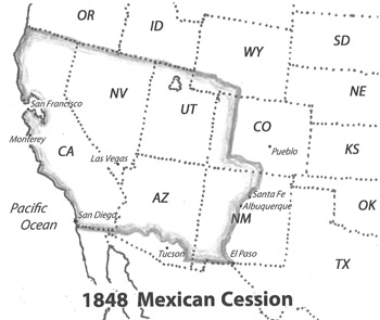
1848 Mexican Cession. As part of the Treaty of Guadalupe Hidalgo ending the war with Mexico, the United States gained ownership to the remainder of New Mexico west of the Rio Grande, including the present areas of Arizona (north of the Gila River), Colorado (west of the continental divide), a portion of southwestern Wyoming; and all of California, Nevada, and Utah. In compensation, the U.S. paid Mexico a sum of 18 million dollars for an area which was over half of the Republic of Mexico, and was comparable in size to the Louisiana Purchase.
1850 (June 1) Federal Census. The provisional Territory of New Mexico included the original seven counties of Bernalillo, Rio Arriba, Santa Ana, Santa Fe, San Miguel, Taos, and Valencia counties. Taos County included an area with all or part of 13 modern Colorado counties. The area of present Arizona north of the Gila River was also part of New Mexico Territory, but no population was enumerated there.
1850 (September 9). California was admitted into the Union as the 31st state; and on the same day, Congress established both Utah Territory and New Mexico Territory.
1852. Doña Ana County was established, stretching across the southern portion of New Mexico Territory, well into the area that later became Arizona.
1853 Gadsden Purchase. Seeking access for a southern railroad route, the U.S. paid Mexico a sum of 10 million dollars to purchase a 45,000 square mile tract of land south of the Gila River. The purchase was negotiated by James Gadsden (of Georgia), minister to Mexico, who, along with Jefferson Davis (of Mississippi), had earlier proposed a plan to build a transcontinental railroad that would link the southern states to the Pacific. In 1853, these two prominent southern leaders saw the Gadsden Purchase as the first step to a southern-confederate dominance of the region. The area of the Gadsden Purchase was added to New Mexico Territory, which immediately expanded Doña Ana County to include the entire area.
1859. New Mexico Territory created Arizona County from Doña Ana, the Gadsden Purchase area of present Arizona south of the Gila River.
1860 Federal Census. New Mexico Territory’s population of 93,516 people was enumerated in areas of present southern Colorado, and all of present Arizona and New Mexico. Arizona’s enumeration was in Arizona County, New Mexico Territory, including the few settlements just north of the Gila River; plus Fort Mojave on the Colorado River, technically in New Mexico’s Valencia County, but enumerated in Arizona County.
1861. The U.S. Congress created Colorado Territory. In doing so, New Mexico Territory lost the northern-most parts of Taos and Mora counties to the new Colorado Territory.
1861. After the Confederate victory at the Battle of Mesilla, the Territory of Arizona was self-declared on August 1, 1861, and recognized by the Confederate Congress several weeks later. The Territory of Arizona, with the capital at Mesilla, was defined as that area of pre-war New Mexico Territory south of the 34th parallel. Of the few surviving contemporary maps of the area, one refers to the only Confederate territory as “the horizontal Territory of Arizona.” Less than a year later, Union troops occupied the area again, and in effect, the Confederate Territory of Arizona ceased to exist.
1862 (February). Confederate troops from Texas invaded and occupied New Mexico Territory, mostly the settlements along the Rio Grande Valley, but also as far west as Tucson. In April, the battle of Velvarde and Glorieta Pass was fought to a stalemate, but soon after, the Confederate armies were forced to retreat from New Mexico. Confederates troops did not leave Tucson until 1863.
1862. Arizona County, New Mexico Territory, was abolished, the area returned to its parent, Doña Ana County.
1863. Just months after the ephemeral Confederate Territory of Arizona was overrun by Union Troops, the U.S. Congress decided to assert Union influence in the area by creating Arizona Territory, with Prescott as the capital. No civil government was established in the new territory for over a year, and as a Civil War offspring, Arizona Territory was first governed as a military district. The northern boundary of Arizona Territory extended west to the California line, and thus, the first Arizona Territory included all of present Las Vegas / Clark County, Nevada. When Congress divided New Mexico Territory on the same meridian as Colorado’s western line, the resulting map created the “four corners” of Colorado, Utah, Arizona, and New Mexico, still the only point in the U.S. where four states join at their corners.
1864. An Arizona Territorial census was conducted, mandated by the organic act under which the territory was formed, and enumerated within three judicial districts (before the first counties were created). The 1864 census was enumerated by the U.S. military government.
1865-1871 Pah-Ute County. Created from Mohave in 1865, Pah-Ute was the first county created after the four original counties of Pima, Yuma, Yavapai, and Mohave were created by Arizona Territory in 1864. The original area of Pah-Ute spanned both sides of the Colorado River, east to the present Mohave line (which in 1870 extended north to the Utah border), and west to the original 1863 border with California. Until 1869, Pah-Ute covered most of present-day Clark County, Nevada, and included Mormon Fort, now the city of Las Vegas. No county records for Pah-Ute County exist, but at least one census was taken under the name Pah-Ute. (See the 1866 AZ territorial census). When the Nevada-Arizona boundary was adjusted in 1869 to the Colorado River, a remnant of old Pah-Ute east of the river was left as part of Arizona Territory. In preparing for the 1870 federal census, geography was not a strong suit among the census enumerators. The ranchers living in the Pah-Ute remnant area were ignored by the Arizona Territory census takers. Instead, they were enumerated within Nevada’s Lincoln County and Utah’s Rio Virgin County. Rio Virgin County was erroneously established by Utah Territory entirely within Nevada and not abolished until 1872. Pah-Ute county was officially abolished in 1871, the remnant area returned to its parent, Mohave County.
1867. The Arizona territorial capital was moved from Prescott to Tucson.
1869. John Wesley Powell and party explored the Grand Canyon by river boat.
1870 Federal Census. Arizona Territory’s population was at 9,658. Refer to the AZ 1870 map on page AZ-10 (in the Arizona Name Lists book).
• 1870 NOTE: The 1870 Mortality Schedule for Tombstone, Arizona Territory listed the name, age, nativity, and cause of death of all persons who died between June 1, 1869 and May 31, 1870. Most of the deaths were caused by gunshots or knife wounds, with a couple of hangings, and one rattlesnake bite. At the end of the schedules, the census enumerator wrote a few words of explanation, saying “. . . many of our young men settle their differences of opinion in the middle of the street.”
1880. In March, the Southern Pacific railroad reached Tucson, Arizona Territory, completing the route from Los Angeles. The Southern Pacific had purchased a railroad running from the Atlantic Coast to Texas, and was now starting the connection from Arizona Territory to Texas. In 1881, The Southern Pacific crossed Arizona and New Mexico territories, and with the completion of the leg to Sierra Blanca, Texas, the SP became the second transcontinental railroad. It was no coincidence that the same “big four” California investors of the first transcontinental railroad of 1869, were also the owners of the second. Stanford, Crocker, Huntington, and Hopkins bought the Southern Pacific in 1868, merged it into the Central Pacific in 1870, and completed the connection from San Francisco to Los Angeles in 1876. By 1877, the SP was well on its way to Arizona.
1880 Federal Census. Arizona Territory’s population was at 40,440. After microfilming, the National Archives gave away the original 1880 census schedules for Arizona Territory, which was bound into one large volume. That bound volume is now located at the DAR Library in Washington, DC.
• 1881 NOTE: On October 26, 1881, Wyatt Earp, Doc Holliday, and three more Earp brothers were involved in a gunfight at Tombstone’s OK Corral. According to the last ten movies depicting the event, the Earps were the good guys.
1886. After leaving his hideout in Arizona, the great Apache Chief Geronimo surrendered to soldiers on September 4, marking the end of the Indian wars in the West.
1889. The Arizona territorial capital was moved from Tucson to Phoenix.
1900 Federal Census. The population of Arizona Territory rose to 122,931.
1912. (Feb. 14th, Valentines Day), Arizona became the 48th state, with Phoenix as the state capital.
From: Arizona Name Lists 1684 – 2003, with a selection of National Name Lists, 1600s – Present
One time I was returning from a genealogy seminar in Texas, and found myself trying to find a bridge across the Colorado River somewhere near Bullhead City, Arizona. I recall the temperature that day was 124 degrees. One day last week, Bullhead City was the hottest place in the U.S. at 128 degrees, beating out Death Valley by 2 degrees. One advantage to living in Bullhead City is that across the river in Laughlin, Nevada are several large casinos (with 10,000+ slot machines) and all are well air-conditioned. -bill$hide