The following article was written by my friend, William Dollarhide:
 Dollarhide’s Rule No. 24: A cousin, once removed, may not return.
Genealogists attempting to identify the places their ancestors lived using the federal censuses must first face the reality of changing county boundaries. That is because all censuses taken since 1790 are tabulated and organized by the counties within each state or territory. As areas increased in population, the states created new counties to handle the needs of the local populace.
Initially created in Virginia in 1634 and in Massachusetts in 1643, the U.S. county has not received its historical due, such as being one of the pioneers’ most vital tools in the westward movement. The county has been both a historical success and a survivor, supplying for most Americans in the eighteenth and nineteenth centuries their most accessible government. Even today, when the great majority of Americans live in incorporated urban areas, the county refuses to disappear, though some county/city consolidation has taken place, such as Marion County/Indianapolis, Indiana; Duval County/Jacksonville, Florida; Ormsby County/Carson City, Nevada; and Davidson County/Nashville, Tennessee. But the county, a leftover from the horse and buggy days, continues to function across nearly the whole nation, just as it did for the first federal census of 1790.
By federal precedence, a county area in a census is the basic unit of jurisdiction in all states except Alaska and Louisiana, where the Census Bureau has identified “county-equivalents.” Alaska is the only state which has never had counties. The Alaska boroughs (i.e., “municipalities”) are used as county-equivalents, even though there are large areas of Alaska that are not in any borough. So, on its own, the Census Bureau created an “Unorganized Borough” in Alaska as a county-equivalent. In Louisiana, a parish is the same as a county in other states, and the Census Bureau refers to a Louisiana Parish is a “county-equivalent.”
In the New England states, a town may have more importance than a county as a genealogical resource center. For example, vital records usually originate at a county courthouse in most states, but in the New England states, they originate in a town hall. Even so, the Census Bureau still uses a county as the basic unit of jurisdiction within the states of Connecticut, Maine, Massachusetts, New Hampshire, Rhode Island, and Vermont; as in all other states. Although Rhode Island and Connecticut both abolished county government years ago – the county boundaries in both states were retained as judicial divisions and for the purpose of geographical studies based on a county area (such as a census).
Genealogists learn early the importance of the county as a jurisdiction, because it is usually the main location that needs to be known before one can find a name of a resident anywhere in the U.S. Therefore, finding the right county is a big step in genealogical research, not only because of the census records relating to that county, but the many other records that are specific to a certain county or locality.
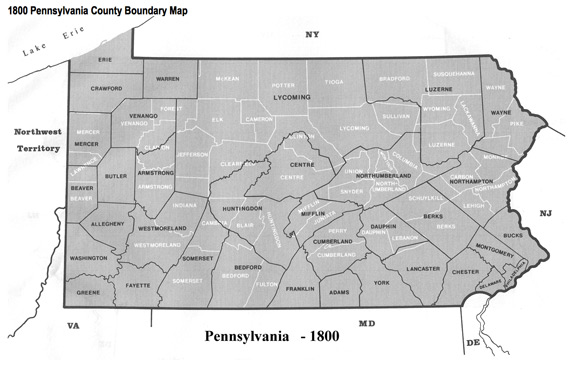
County Boundary Changes in Pennsylvania
Since the basic census enumeration unit in all censuses was a county, understanding the genealogy of counties is part of locating the place where an ancestor lived. For example, if a genealogist knows that an ancestor lived in Allegheny County, Pennsylvania in 1790, the county courthouse there is a resource for old deeds, births, marriages, tax lists, and other court records, and a place where an ancestor’s name may be mentioned.

In 1800, due to the formation of counties taken from Allegheny, there were parts or all of nine counties covering the same area: parts of Armstrong, Venango, and Warren counties, and all of Allegheny, Beaver, Butler, Mercer, Crawford, and Erie counties. In most cases, when a genealogist finds an ancestor living in Allegheny County in 1790, but living in Butler County in 1800, the family did not move – the county boundaries moved.
County Boundary Changes in Oregon
The Link River is a very short (1.5 miles long) river that starts at the southern end of the Upper Klamath Lake and empties into Lake Ewauna, located in South-central Oregon about 20 miles north of the California border. The first whites to visit this area was in 1846, when Jesse and Lindsay Applegate and others blazed a new southern wagon road to Oregon leaving the old Oregon Trail at Fort Hall (now Idaho), into Nevada, California, and then north to the Klamath Basin, where the Link River was located. The Applegate Trail then continued west across the Cascade Mountains to the Rogue River Valley of Southern Oregon.
In the 1860s, a man named George Nurse followed the Applegate Trail and saw the Klamath Basin as a great place to start a store and hotel. He obtained a claim of 160 acres on the Link River, and built a house, a store, and a hotel there. In 1867, George Nurse founded the town of Linkville, located on the falls of the Link River. At first, the new town encompassed just his house, hotel, and store. To erect the buildings, he had rafted lumber from a sawmill at Fort Klamath near the top of Upper Klamath Lake down to the new town of Linkville, a distance of some 42 miles. Due to its location on the Applegate Trail, the town of Linkville began to grow, and several sawmills began operating there. By the late 1880s, Linkville had become an important railroad center in Southern Oregon. In 1892, the name of the town was changed to Klamath Falls. The spot on the ground where that hotel/store was located went through five county boundary changes from 1850 to 1890.
In 1850, Linn County covered three-fourths of the area of present Oregon, extending from the Columbia River to the border with California. A marriage in 1850 at the spot of George Nurse’s hotel, would have been recorded by the performing minister in Albany, the county seat of Linn County. But in 1860, due to the formation of new counties in Oregon, all marriages performed in the same spot, now in Wasco County, would be recorded in The Dalles, over 300 miles north of there. After the founding of the town of Linkville, a marriage performed there in 1870 was recorded in Jacksonville, the county seat of Jackson County (but later the county seat was moved to Medford). In 1880, any marriage performed in Linkville was recorded in Lakeview, the county seat of Lake County; and in 1890, for the first time, a marriage performed in Linkville was recorded in the same town, since Linkville became the county seat of Klamath County — but then in 1892, the name Linkville was changed to Klamath Falls. The boundaries of Klamath County have not changed since 1890.
The Nurse house/store/hotel never moved. As the settlement of Oregon took place, new counties were created, and earlier county boundaries were changed, placing the spot of Linkville-Klamath Falls in five different counties from 1850 through 1890.
Why Worry About County Boundary Changes?
When a new county is created in any state, the original county records are not moved from a parent county to a progeny county. In rare cases, copies of certain land records may be moved to a new county, if the area of the new county was based on the range/township system and the land records were easily defined as being part of the new county area. But the original county records are retained in the county courthouse of origin. Therefore, all county records, such as births, deaths, marriages, probates, burials, etc., for a family that lived in Linkville, Oregon were spread across the state, and are still stored today in five different county courthouses.
The worry is to understand how the counties changed so we can learn where the records are located today for a particular time period. These examples are not unique to Pennsylvania or Oregon – they can be repeated in virtually every state.
Dollarhide’s Rule No. 32: Your ancestor will be featured in the county history because he was the first prisoner in the new jail.
Counties in the U.S. Censuses, 1790-2010
There have been thousands of new counties created since 1790. The table below shows that the number of counties in the United States increased from 292 in 1790 to 3,143 by 2010. Since 1790 there have been 138 counties reported in the censuses that have since been renamed, abolished, or absorbed into other counties.
Census Year – U.S. Population – No. of States – No. of Counties – Territories/Possessions included in Census
1790 – 3,929,214 – 14 – 292 – Southwest Territory (tally only)
1800 – 5,308,483 – 16 – 419 – Northwest Territory, IN Terr. & MI Terr.
1810 – 7,239,881 – 17 – 574 – IL, IN, MI, MS, LA Terr. & Orleans Territory
1820 – 9,638,453 – 22 – 759 – AR., MI, & MO Terr.
1830 – 12,860,702 – 24 – 988 – AR, FL, & MI Terr.
1840 – 17,063,353 – 26 – 1,279 – IA., FL, & WI Terr.
1850 – 23,191,876 – 30 – 1,623 – MN., NM, OR, & UT Terr.
1860 – 31,443,321 – 33 – 2,080 – KS, NM, NE, UT, WA, Indian Terr. & “Unorganized Dakota”
1870 – 38,558,371 – 37 – 2,295 – AZ., CO, ID, NM, MT, UT, WA, WY, Dakota Terr., & Indian Terr.
1880 – 50,189,209 – 38 – 2,570 – AK, AZ, ID, NM, MT, UT, WA, WY, Dakota Terr., & Indian Terr.
1890 – 62,979,766 – 44 – 2,813 – AK, AZ, NM, OK, UT, & Indian Terr.
1900 – 76,212,168 – 45 – 2,862 – AK, AZ, HI, NM, OK, & Indian Terr.
1910 – 92,228,496 – 46 – 2,962 – AK, AZ, NM, HI, & Puerto Rico
1920 – 106,021,537 – 48 – 3,076 – [ AK, HI, Guam, Midway,
1930 – 123,202,624 – 48 – 3,110 – [ Canal Zone, Puerto Rico,
1940 – 132,164,569 – 48 – 3,108 – [ American Samoa, Virgin
1950 – 151,325,798 – 48 – 3,111 – [ Islands, & Wake Island
1960 – 179,323,175 – 50 – 3,133 – [ Guam, Midway, Canal Zone,
1970 – 203,211,926 – 50 – 3,142 – [ Puerto Rico, American
1980 – 226,545,805 – 50 – 3,137 – [ Samoa, Virgin Islands, &
1990 – 248,709,873 – 50 – 3,141 – [ Wake Island
2000 – 274,952,000 – 50 – 3,139 – [ Guam, Midway, Puerto Rico, American Samoa,
2010 – 308,400,408 – 50 – 3,143 – [ Virgin Islands, & Wake Island
*Note: The sample maps from Pennsylvania were taken from a book by William Thorndale and William Dollarhide, Map Guide to the U.S. Federal Census, 1790-1920 (Genealogical Publishing Co., Inc., 1987). This book has 393 maps showing each applicable census year and all county boundary changes, 1790-1920. Each map shows both the old boundaries (in black) and the modern boundaries (in white) for each state and census year, so a comparison can be made.
The Map Guide may be purchased at the Family Roots Publishing Co. website. Click here for more details about the book.
@Randy. I think your link is very useful. But of course, it may leave some data behind in comparison to these kind of articles.